Callisto Voyager Image Control Network (RAND)
This page has been created as part of a project to put planetary control networks on the web. This control network for Jupiter’s moon, Callisto, originated from Merton Davies and Tim Colvin at the RAND Corporation and was provided to the USGS in 2000. The control network solution was originally performed with software developed at RAND, and documented by Colvin (1992). It was subsequently converted into files that could be used with (successively) the RAND/USGS Planetary Geodesy (RUPG) Software, and the USGS ISIS2 software (using the application, described by Edmundson et al. 2012). In 2020, the RAND control network was converted to the ISIS3 ‘.net’ format. The USGS version of this network is a bundle adjustment of the RAND network using the ISIS3 ‘jigsaw’ program. Each RAND-format control network is essentially a set of photogrammetric solution (input and output) files. The input files consist of, aside from a priori information, measurements of common points (control points, sometimes called tie points) on images of a planetary body. The output files include the body coordinates of the control points in latitude, longitude, and radius, and revised orientation information (camera pointing) for the images. The ISIS3 format (binary) contains all network data in a single file. The primary use of such information is for the creation of image mosaics of the planetary body. However, these solutions can also provide fundamental data on the size and shape of the body, its rotation period, and the direction of its polar axis in space. The control point coordinates also usually serve as a coordinate reference frame that defines the fundamental coordinate reference system for the body in question. Formatting of this control network data for Jupiter’s moon, Callisto, has been updated for compatibility with the USGS ISIS2 and ISIS3 cartography software. This network was generated using images from the Voyager I and II missions (Davies et al., 1979). This release is comprised of data from original RAND control network solutions, the ISIS2 qmatch-formatted control network, RAND and USGS solutions to control network in ISIS3 format, and the Voyager I and II images used in the control network (processed to ISIS2 and ISIS3 formats).
Image Description:
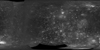
This image is a USGS controlled photomosaic of Callisto, compiled from Voyager 1 and 2 images. We believe this 1992 image was created either form the RAND control network provided here, or from an updated version of the same network.
- Mimetype
- application/zip
- Filename
- Callisto_data.zip
- Author
- Brent Archinal
- Originator
- USGS Astrogeology Science Center
- Added to Astropedia
- 31 December 2015
- Modified
- 7 July 2021
General
- Purpose
Created as part of a project to put planetary geodesy control networks on the web. The Callisto Voyager control network data here was originally provided by Merton Davies and Tim Colvin of the RAND Corporation. Funds were provided for a conversion and archiving effort by the NASA Planetary Geology and Geophysics Program and the NASA Cartography Program.
- Geospatial Data Presentation Form
- Control Network
Keywords
- System
- Jupiter
- Target
- Callisto
- Theme
- Control Network
- Mission
- Voyager
Contact and Distribution
- Access Instructions
Contained in the ZIP file are the necessary data to open the RAND solution of the Callisto control network in ISIS3 programs, in the ISIS2 qmatch format (.mat) and in its original RAND solution format. The ZIP file also contains all necessary ISIS2 and ISIS3-formatted images necessary re-create the control network. Scripts are provided to re-generate these images from PDS (.imq) format into the ISIS2 (.cub) format, if necessary.
Callisto_data.zip Contents:
ISIS3 Control Network:
Callisto_control_RAND.net – RAND solution measurements in ISIS3 format. Converted to ISIS3 by the routine mat2cnet.
Callisto_control_images.zip – All Voyager I & II images in the Callisto control network, formatted as ISIS3 (.cub) files. These are required to open the control network in ISIS3. ISIS2 (.cub) files are also included.
Control Network in previous formats:
Voyager data only (RAND):
zche.dat – RAND solution residual output file.
caxy0.dat – RAND solution image measurements (mm and pixels) input file.
caxy0.mat – RAND solution image measurements (mm and pixels) in ISIS2 qmatch match point format.
caxy0_adj.mat – Same as caxy0.mat, slightly reformatted to be read by the ISIS3 routine mat2cnet. In this version the line and sample columns have been transposed, and no data are altered.
zinp.dat – RAND solution “poles, points, and positions” a priori input file.
zmea.dat – RAND solution image measurements (mm) input file.
zout.dat – RAND solution “poles, points, and positions” output file.
zout_adj.dat – RAND solution “poles, points, and positions” output file adjusted to be read by the ISIS3 routine mat2cnet. In this version, the exponential notation is expressed with E+/E- rather than D+/D-. Unused ‘junk’ spaces and hidden characters have also been removed; no data were altered.
zpar.dat – RAND solution program operation control input file.
Voyager and Galileo data combined (USGS):
wche.dat – residual output file.
winp.dat – “poles, points, and positions” a priori input file.
wmea.dat – image measurements (mm) input file.
wout.dat – “poles, points, and positions” output file.
wout_adj.dat – “poles, points, and positions” output file adjusted to be read by the ISIS3 routine mat2cnet. In this version, the exponential notation is expressed with E+/E- rather than D+/D-. Unused ‘junk’ spaces and hidden characters have also been removed; no data were altered.
Documentation and Information:
Callisto_image_list.txt – Text file listing all Voyager I & II images in the Callisto control network. These images are archived at pds.nasa.gov in PDS (.imq) format. Scripts to process these into ISIS2 (.cub) or ISIS3 (.cub) formats are included here.
caxy0_ISIS2_lev0_script – ISIS2 image processing script that converts PDS-formatted (.imq) images to the ISIS2 (.cub) format. Use of the ISIS3 routine mat2cnet to convert ISIS2 control networks (.mat) into the ISIS3 format (.net) requires input from all component images in both ISIS2 and ISIS3 formats.
caxy0_ISIS3_lev0_script – ISIS3 image processing script that converts PDS-formatted (.imq) images to the ISIS3 (.cub) format. Use of the ISIS3 routine mat2cnet to convert ISIS2 control networks (.mat) into the ISIS3 format (.net) requires input from all component images in both ISIS2 and ISIS3 formats.
ISIS-PG-FMT101_ISIS3_net – Description of format of file Callisto_control_RAND.net (in PDF format).
ISIS-PG-FMT101_XXxy0_dat – Description of format of file caxy0.dat (in PDF format).
ISIS-PG-FMT101_XXxy0_mat – Description of format of file caxy0.mat (in PDF format).
ISIS-PG-FMT501_zpar_dat – Description of format of file zpar.dat (in PDF format).
ISIS-PG-FMT502_zout_dat – Description of format of file zout.dat (in PDF format).
ISIS-PG-FMT503_zmea_dat – Description of format of file zmea.dat (in PDF format).
ISIS-PG-FMT511_zche_dat – Description of format of file zche.dat (in PDF format).
Data Status and Quality
- Completeness Report
This is a global control network of Callisto, and incorporates most of the usable images from the Voyager I and II missions.
- Process Description
RAND solution files from the 1980’s are provided as *.dat files. The conversion to ISIS2 match point format (.mat) was performed in 2003 without making corrections or adjustments to the network.
Lineage
- Source Originator
- RAND
- Source Title
- Control Networks for the Galilean Satellites: November 1979
- Source Online Linkage
- http://www.rand.org/content/dam/rand/pubs/reports/2006/R2532.pdf
- Type of Source Media
- Online
Geospatial Information
- Direct Spatial Reference Method
- Point
- Quad Name
- Horizontal Coordinate System Units
- Degrees


