This digital terrain model (DTM) was produced as part of an effort to characterize topography within candidate landing ellipses for the Mars InSight mission and to aid entry, descent, and landing…
Product Information: This mosaic represents SELenological and Engineering Explorer (SELENE) Kaguya Multiband Imager (MI) derived submicroscopic metallic iron (SMFe; Taylor et al., 2010). The mosaic…
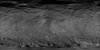
Product Information: The Dawn Framing Camera (FC) captured images of Ceres with a resolution of about 140 meters per pixel (m) in 2015 (Preusker et al., 2016). German Aerospace Center (DLR)…
Product Information: DAWN orbited Vesta during HAMO in 21 cycles between December 2011 and end of April 2012. Dawn orbited Vesta during HAMO in 6 cycles between end of September end early November…
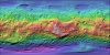
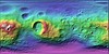
Product Information: This is a colorized shaded-relief of the original stereo-derived High Altitude Mapping Orbit (HAMO) digital terrain model (DTM). DAWN orbited Vesta during HAMO in 21 cycles…
Product Information: DAWN orbited Vesta during HAMO in 21 cycles between December 2011 and end of April 2012 and in 6 cycles between end of September end early November 2011. The FC took about 2,500…
Product Information: This is a shaded-relief of a original polar digital elevation model (DEM) from the Lunar Orbiter Laser Altimeter (LOLA; Smith et al., 2010), an instrument on the National…
Product Information: This Lunar Orbiter (LO) mosaic of the Moon was constructed using photographs acquired by LO III, IV and V. Work towards constructing the global mosaic spanned over seven years.…
Product Information: This is a colorized shaded-relief of the original High Resolution Stereo Camera (HRSC) Digital Elevation Model (DEM) with a resolution of 100 meters per pixel (m). HRSC images…
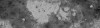
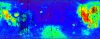
Product Information: Clementine derived iron abundance (as weight percent iron oxide [FeO]) data. This FeO map is derived from Clementine Ultraviolet/Visible camera (UVVIS) data as described by…