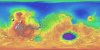
Mars MGS MOLA Global Color Shaded Relief 463m v1
application/isis 3 GBProduct Information:
This map is based on data from the Mars Orbiter Laser Altimeter (MOLA) (Smith, et al., 2001), an instrument on NASA’s Mars Global Surveyor (MGS) spacecraft (Albee, et al.,…