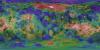
Product Information: This product represents a near-global lunar topography from stereo image data acquired by the Wide-angle Camera (WAC) of the Lunar Reconnaissance Orbiter Camera (LROC) system…
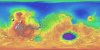
Product Information: This mosaic was created from the Magellan Full resolution Basic Image Data Records (F-BIDRs), the highest resolution radar images of the Venus surface (~75 meters per pixel…
This is a shaded relief of the original DEM described next. This data product, now at version 2, is a blend of digital elevation model (DEM) data derived from the Mars Orbiter Laser Altimeter (MOLA),…
Product Information: This map is based on data from the Mars Orbiter Laser Altimeter (MOLA) (Smith, et al., 2001), an instrument on NASA’s Mars Global Surveyor (MGS) spacecraft (Albee, et al.,…
This archive contains topography and photometric data generated by the Gaskell Stereophotoclinometry (SPC) software suite. It focuses on six regions on the Moon. These include wrinkle ridges at Dorsa…
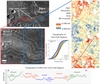
This product represents adirectional topographic slopes over 20 meter horizontal baselines within part of a candidate landing site for the Mars2020 mission. The slope map was derived from a CTX-based…
This digital terrain model (DTM) was produced as part of an effort to characterize topography within candidate landing ellipses for the Mars2020 mission and to aid entry, descent, and landing…