During the Clementine Mission both oblique and vertical multispectral images were collected. The oblique and vertical images from a single spectral band collected during the same orbit form a stereo…
The utility (read: need) of topographic data in formulating and testing hypotheses for the formation of geologic features is undisputed. In the absence of laser altimeters, however, image-based…
We describe a series of programs and scripts under development for the USGS digital cartography and image processing software system ISIS that will make it possible for users to create digital…
Topographic mapping of icy satellites is a critical tool for evaluation of geologic problems ranging from the origin of ionian mountains to the thickness of floating ice shells. With the lack of…
On such a volcanically active world as Io, topography is especially important for understanding lava emplacement, mountain formation, internal dynamics, and volcanic history. Previously we have…
High-precision topographic information from all available data is crucial to many landing site geological and engineering applications. At the same time, precise navigation and localization of the…
We describe our initial experiences producing controlled digital elevation models (DEMs) of Mars with horizontal resolutions of ≤10 m and vertical precisions of ≤2 m. Such models are of intense…
More than ever before the planet Mars is subject to exploration and mapping activities. Since 1992 the Technical University of Berlin was involved in the software development for photogrammetric and…
Cassini observations show that Saturn’s moon Titan is slightly oblate. A fourth-order spherical harmonic expansion yields north polar, south polar, and mean equatorial radii of 2574.32 T 0.05…
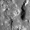
Product Information: The discovery of hollows on Mercury remains one of the most surprising scientific findings by MESSENGER. Hollows are sharp-edged, irregular, rimless pits that are often…