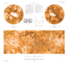
Assorted Lunar Images and Data from 1965 to 1992 Presented here are safed versions of variety of data selected from a collection of data commonly referred to as the Lunar Consortium Data. This…
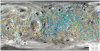
In a large majority of lunar and planetary surface images, impact craters are the most abundant geological features. Therefore, it is not surprising that crater detection algorithms (CDAs) are one of…
Product Information: This is a shaded-relief of the original Digital Elevation Model (DEM) produced from images from the High Resolution Stereo Camera (HRSC) aboard the European Space Agency's (ESA)…
These files are part of the Global Topographic Data Record (GTDR) series of Digital Map Products (DMP) produced by the Cassini RADAR Science Team. They contain a variety of different models for the…
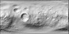
This product represents a CTX digital elevation model (DEM/DTM) mosaic at 20 m/pixel from stereo pairs covering Jezero crater. This mosaic includes the original Mars 2020 Jezero CTX TRN DEM but…
Product Information: This uncontrolled Digital Elevation Model (DEM) was created to investigate the terrain of the Tvashtar Paterae volcanic region on Io, using stereo imagery from the Galileo…
Product Information: In this Global Slope Data Record (GSDR) the surface meter-scale slopes are derived by fitting altimeter echoes from the fan-beam altimetry antenna as a function of time to…
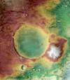
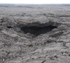
Abstract Diurnal and annual temperature variations in some Atypical Pit Craters (APCs) on Mars may be affected by the presence of interior cave entrances (Cushing et al., 2007; Cushing et al.,…
Product Information: This map is based on data from the Lunar Orbiter Laser Altimeter (LOLA; Smith et al., 2010), an instrument on the National Aeronautics and Space Agency (NASA) Lunar…