Products

94 Results Collapse
Mars 2020 Terrain Relative Navigation HiRISE DTM Mosaic thumbnail

Mars 2020 Terrain Relative Navigation HiRISE DTM Mosaic

image/tiff 1 kBJul 24 2020

The Mars 2020 rover will explore Jezero crater, Mars to investigate an ancient delta for evidence of past microbial life and to better understand the geologic history of the region. The landing…

Mars 2020 Terrain Relative Navigation CTX DTM Mosaic thumbnail

Mars 2020 Terrain Relative Navigation CTX DTM Mosaic

image/tiff 1 kBJul 24 2020

The Mars 2020 rover will explore Jezero crater, Mars to investigate an ancient delta for evidence of past microbial life and to better understand the geologic history of the region. The landing…

Moon Apollo 17 LROC NAC Landing Site Orthomosaic 50cm v1 thumbnail

Moon Apollo 17 LROC NAC Landing Site Orthomosaic 50cm v1

application/zip 6 MBMay 01 2018

Product Information: This is an (ortho-) mosaic map of the Apollo 17 landing site (L15K 20.2/30.7East COMT). The map includes nomenclature, elevation contours, the astronauts' major geology stops,…

Mars MSL Gale Merged Orthophoto Mosaic 25cm v3 thumbnail

Mars MSL Gale Merged Orthophoto Mosaic 25cm v3

image/tiff 4 MBOct 20 2016

Product Information: This basemap was initially created as an assessment tool for the entry, descent, and landing (EDL) analysis conducted by the Mars Science Laboratory (MSL) engineering team to…

Mars MSL Gale Merged DEM 1m v3 thumbnail

Mars MSL Gale Merged DEM 1m v3

image/tiff 170 kBOct 20 2016

Product Information: This digital elevation model (DEM) was initially created as an assessment tool for the entry, descent, and landing (EDL) analysis conducted by the Mars Science Laborarory (MSL)…

Context Camera (CTX) Image Mosaics for Mars Human Exploration Zones 5m thumbnail

Context Camera (CTX) Image Mosaics for Mars Human Exploration Zones 5m

image/tiff 2 MBJul 01 2016

We have created 39 regional semi-controlled CTX mosaics at 5m/pixel for the 2015 proposed Mars Human Exploration zones. They are individually available for download in GeoTiff format from the "Online…

Moon LRO LOLA Color Shaded Relief 388m v4  thumbnail

Moon LRO LOLA Color Shaded Relief 388m v4

application/isis 3 GBAug 01 2011

Product Information: This is a colorized shaded-relief of a original polar digital elevation model (DEM) from the Lunar Orbiter Laser Altimeter (LOLA; Smith et al., 2010), an instrument on the…

Gusev Crater MER Landing Site Ellipse THEMIS IR Mosaic thumbnail

Gusev Crater MER Landing Site Ellipse THEMIS IR Mosaic

application/isis 23 MB

In 2003-2005, the USGS worked under the guidance of NASA's Mars Critical Data Products Initiative to conduct research on how controlled large area or global 2001 Mars Odyssey THEMIS IR image mosaics…

Moon Apollo 17 LROC NAC Orthomosaic 50cm v1 thumbnail

Moon Apollo 17 LROC NAC Orthomosaic 50cm v1

image/tiff 1 kBMay 01 2018

Product Information: This is an orthomosaic of the Apollo 17 landing site created from images provided by the Lunar Reconnaissance Orbiter (LRO) Camera (LROC) Narrow Angle Camera (NAC). The images…

Meridiani Plnum MER Landing Site Ellipse THEMIS IR Mosaic thumbnail

Meridiani Plnum MER Landing Site Ellipse THEMIS IR Mosaic

application/isis 21 MB

In 2003-2005, the USGS worked under the guidance of NASA's Mars Critical Data Products Initiative to conduct research on how controlled large area or global 2001 Mars Odyssey THEMIS IR image mosaics…

Project Pages

4 Results Collapse
GIS Tools thumbnail

GIS Tools

http://astrogeology.usgs.gov/facilities/mrctr/gis-tools

Tools for ArcMap 10.x …

Interactive GIS Map of the Moon thumbnail

Interactive GIS Map of the Moon

http://astrogeology.usgs.gov/facilities/mrctr/moon-online-map

Layers available for download from:USGS AstrogeologyData Portal: Astropediahistorical FTP downloads

Laboratory Infrared Spectroscopy of Mars Analog Materials thumbnail

Laboratory Infrared Spectroscopy of Mars Analog Materials

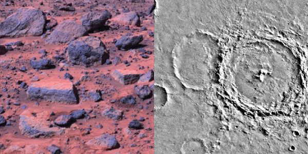
http://astrogeology.usgs.gov/geology/mars-pathfinder-infrared-spectroscopy

Former USGS scientist, Jeff Johnson, performed key research on the detection of dust on the Martian surface. This work explored the laboratory thermal infrared and visible/near-infrared spectroscopy…

Mars Science Laboratory - Landing Site Selection thumbnail

Mars Science Laboratory - Landing Site Selection

http://astrogeology.usgs.gov/maps/mars-science-laboratory-landing-site-selection

Image Information and Instructions The ISIS cube file can be loaded into JMars as a custom map. You can download JMars at the following site: http://jmars.asu.eduFor instructions on how to load a…

Documents

11 Results Collapse
ISPRS 1998 Mars Pathfinder: Photogrammetric Processing of Lander Images and Cartographic Analysis of the Landing Site from Orbit thumbnail

ISPRS 1998 Mars Pathfinder: Photogrammetric Processing of Lander Images and Cartographic Analysis of the Landing Site from Orbit

application/pdf 66 kB

Following the successful landing of the Mars Pathfinder, DLR has carried out a comprehensive study of the Pathfinder landing site in terms of geology, mineralogy, and surface photometric properties.…

ISPRS 1998 USGS Experiences Mapping the Mars Pathfinder Landing Site thumbnail

ISPRS 1998 USGS Experiences Mapping the Mars Pathfinder Landing Site

application/pdf 99 kB

The Imager for Mars Pathfinder (IMP) obtained 5 full panoramic sets of images, varying in color and stereo coverage and degree of data compression, from the highly compressed First Look to the…

ISPRS 1998 Precision Cartographic mapping of the Pathfinder landing site thumbnail

ISPRS 1998 Precision Cartographic mapping of the Pathfinder landing site

application/pdf 86 kB

Viking Orbiter images were reprocessed using new techniques to produce a precision controlled, photomosaic map of the Mars Pathfinder landing site prior to landing. The difference between the…

ISPRS 1999 USGS Mapping of the Mars Pathfinder Landing Site: Progress and Plans thumbnail

ISPRS 1999 USGS Mapping of the Mars Pathfinder Landing Site: Progress and Plans

application/pdf 112 kB

This abstract describes progress in cartographic processing of data from the Imager for Mars Pathfinder (IMP) by the U. S. Geological Survey in the past year, and plans for advanced cartographic…

ISPRS 1999 Stereogrammetric Mapping on Mars: Promise, Progress, and Problems thumbnail

ISPRS 1999 Stereogrammetric Mapping on Mars: Promise, Progress, and Problems

application/pdf 46 kB

To assist in landing site selection, we are compiling a suite of stereo images of potential landing sites for the 1998 and 2001 Mars landers. From these, we are using automated stereogrammetry…

ISPRS 1999 SSI / RAC: Imagers for Mars Polar Lander thumbnail

ISPRS 1999 SSI / RAC: Imagers for Mars Polar Lander

application/pdf 27 kB

The Mars Volatiles and Climate Surveyor (MVACS) instrument payload on the Mars Polar Lander includes two imagers designed and constructed at the Lunar and Planetary Laboratory at the University of…

ISPRS 1999 An Image Map of the Mars Pathfinder Landing Site thumbnail

ISPRS 1999 An Image Map of the Mars Pathfinder Landing Site

application/pdf 13 kB

On 4 July 1997, the Pathfinder spacecraft landed on Mars near the mouth of the outflow channel Ares Vallis, located in the southern part of Chryse Planitia. Between July 4 and September 27, 1997, the…

ISPRS 1999 FIDO / APEX / Athena-Based Plans for Cartographic Products and Rover Localization Analyses thumbnail

ISPRS 1999 FIDO / APEX / Athena-Based Plans for Cartographic Products and Rover Localization Analyses

application/pdf 18 kB

In this abstract we preview the acquisition of stereo image data and resultant cartographic products and rover localization studies associated with the Athena Precursor Experiment (APEX) on the 2001…

ISPRS 1999 Constraints, Approach, and Status of Mars Surveyor '01 Landing Site Selection thumbnail

ISPRS 1999 Constraints, Approach, and Status of Mars Surveyor '01 Landing Site Selection

application/pdf 13 kB

There are many similarities between the Mars Surveyor '01 (MS '01) landing site selection process and that of Mars Pathfinder. The selection process includes two parallel activities in which…

ISPRS 2001 High Precision Landing Site Mapping and Rover Localization by Integrated Bundle Adjustment of Ground-Based Image Data thumbnail

ISPRS 2001 High Precision Landing Site Mapping and Rover Localization by Integrated Bundle Adjustment of Ground-Based Image Data

application/pdf 10 kB

High precision topographic information from all available data is critical to many landing site geological and engineering applications. Meanwhile, precise navigation and localization of the rover is…