Regional Topography and Photometric Cube Data for Lunar Locations
- Originators
- Weirich, J.R., Palmer, E.E., Gaskell, R., Domingue, D.L.
- Publisher
- USGS Astrogeology Science Center
- Publication Date
- 2023-05-15
- Abstract
-
This archive contains topography and photometric data generated by the Gaskell Stereophotoclinometry (SPC) software suite. It focuses on six regions on the Moon. These include wrinkle ridges at Dorsa Aldrovandi, two locations of the lunar swirl within Mare Ingenii, Karpinskiy crater, a swirl within Mare Moscoviense, Reiner Gamma, and Tsiolkovskiy crater. We generated regional Digital Terrain Models (DTM), each about 50 to 100 square kilometers, using Lunar Reconnaissance Orbiter (LRO) Narrow Angle Camera (NAC) images from both the right and left cameras. Depending on the location, each vertex of the topography represents heights every 5 to 0.7 meters, with an uncertainty of about one to two vertices. The topography data is provided in both cubes readable by the USGS ISIS program, and as a geoTIFF which can be read by programs such as ArcGIS. We generated photometric data (in cube format) that is aligned to, and has the same horizontal spacing as, the topographic cube data. For each LROC image, four cubes were generated; I/F (reflectance), Local Phase Angle, Local Emission Angle, and Local Incidence Angle. Each cube pixel represents the value at each vertex of the DTM.
PDS4 DOI: 10.17189/jdpv-z697
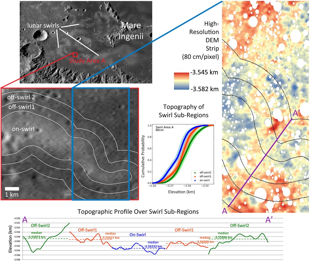
image credit: Domingue et. al., 2022
Nearest Feature Name	Center Lat/East Lon	Size (km)
Dorsa Aldrovandi	 25.84/29.07		10 by 10
Mare Ingenii (Loc 1)	-35.84/161.81		9  by 9
Mare Ingenii (Loc 2)	-33.59/163.35		9  by 9
Karpinskiy Crater	 73.77/167.61		5  by 20
Mare Moscoviense	 26.51/144.34		7  by 7
Reiner Gamma Swirl	 7.02/300.80		7  by 7
Tsiolkovskiy Crater	-19.42/128.57		10 by 10
Access instructions: currently this archive is available from an Amazon S3 bucket. To access that please find the listing for each file above (or from this index.html listing). Example Amazon aws command-line options for listing or downloading this archive. Listing the archive:aws s3 ls --no-sign-request --recursive s3://asc-pds-individual-investigations/lunar_lro_lroc_topography_domingue_2023/
aws s3 sync --no-sign-request s3://asc-pds-individual-investigations/lunar_lro_lroc_topography_domingue_2023/ /my/local/path/.
- Purpose
- Topographic correlations within lunar swirls.
Contact and Distribution
- Format
- Digital Elevation Model, Grey Scale, Image, Raster Data, Topographic Map
- Access Constraints
- None
- Access Scope
- PDS
- Use Constraints
- Please cite authors
- Supplemental Information
- https://www.lroc.asu.edu/
- Native Data Set Environment
- ESRI Arcinfo, ISIS v3
- Astrogeology Theme
- Geophysical, Image Processing, Photoclinometry, Topography
- Mission Names
- Lunar Reconnaissance Orbiter
- Instrument Names
- LROC
- Online Package Link
- https://astrogeology.usgs.gov/search/map/regional_topography_and_photometric_cube_data_for_lunar_locations
- External File Size
- Archive (16 GB)
- Online File Link
- https://asc-pds-individual-investigations.s3.us-west-2.amazonaws.com/lunar_lro_lroc_topography_domingue_2023/index.html
- Access Instructions
- See abstract for instructions.
- Contact Address
- 2255 N. Gemini Drive
- Contact City
- Flagstaff
- Contact State
- AZ
- Contact Postal Code
- 86001
- Contact Email
- [email protected]
Data Status and Quality
- Time Period of Content (start)
- 2022-09-06
- Currentness Reference
- Publication date
- Progress
- Complete
- Update Frequency
- None planned
- Logical Consistency
- Topography Data: We generated regional Digital Terrain Models (DTM) using LROC NAC images from both the right and left cameras. The topography data is provided in both cubes readable by the USGS ISIS program, and as a geoTiff which can be read by programs such as ArcGIS. Estimates of the topographic error of SPC DTMs come from testing for the OSIRIS-REx mission. Weirich et al (2022) used a synthetic, but realistic, digital asteroid with known heights to produce a simulated mission image suite. With only these images, and no access to the synthetic asteroid, we generated an SPC global DTM. This SPC DTM was then compared to the original synthetic DTM to characterize the actual errors. Weirich et al (2022) showed that a sufficient, but not ideal, image set produced DTMs that were typically accurate to one image pixel. The worst vertex in the test DTM was accurate to about three image pixels. We use the above values as an estimate for the DTM errors in this package. The image set of this package is comparable to the sufficient, but not ideal, image set of the OSIRIS-REx tests. Unlike the OSIRIS-REx testing, we did not build the DTMs at the image resolution. So instead of the typical vertex being accurate to one image pixel, it is accurate to one DTM vertex. Likewise, the worst DTM vertex is likely to be accurate to three DTM vertices. Photometric Data: We generated photometric data (in cube format) that is aligned to and has the same horizontal spacing as the topographic cube data. For each LROC image, four cubes were generated; I/F (reflectance), Local Phase Angle, Local Emission Angle, and Local Incidence Angle. Part of the SPC process is to align each image to the topography by adjusting the position and pointing of the spacecraft. The alignment is typically accurate to the size of 1 vertex or better, though rarely for some images in localized areas the misalignment may be as large as 3 or 4 vertices. All angles were determined by the Sun and spacecraft position relative to the height of each DTM vertex. All cubes of a particular location are in the same physical space. In other words, px, ln 100, 100 of the topography cube maps to px, ln 100, 100 in all the other cubes giving I/F, local phase, incidence, and emission angles for all images. Note that while some cubes have values for all pixels, only pixels that correspond to non-zero values in the reflectance cube (i.e. I/F or "ioverf") are valid. Unit Definition Data: Mare Ingenii has unit definition data we used in the analysis of the data (Domingue et al., 2022). This data has three forms, 1) a mosaic of low incidence angle images (i.e. albedo) with craters masked out, 2) a mapping of the Lunar swirls with craters masked out, and 3) a topography map with craters masked out. All unit definition data is given in geoTiff format. Note that product 2) for ings358416181 has mapping of on-swirl=1, off-swirl1=2, off-swirl2=3, no data=4. Off-swirl1 and off-swirl2 were chosen to have the same width to provide data at two distances from the swirl. Product 2) for ings335916335 has on-swirl=1, off-swirl=2, no data=3.
- Completeness Report
- Archive has been published in the PDS at the Imaging Node.
- Process Description
- See: Deborah Domingue, John Weirich, Frank Chuang, Amanda Sickafoose, and Eric Palmer (2022). Topographic correlations within lunar swirls in Mare Ingenii. Geophysical Research Letters, 49, doi:10.1029/2021GL095285 Formats Cubes: The cubes are not projected but are near north up. Orientation vectors are given in the PDS label under local_georeference_information. The cubes are given in "SPC space" so that resampling of the SPC data does not occur. The horizontal spacing between the pixels is the vertex spacing of the DTM (see individual locations below for values). Three cubes fully define the topography. These are topography, latitude, and longitude cubes. The topography cube is the elevation values in meters from the lunar datum of 1737.4 km, the latitude cube is the Latitude value of that vertex in degrees, and the longitude cube is the East Longitude value of that vertex in degrees. Some locations consist of multiple overlapping DTMs. These are noted in the "Location" section. GeoTiff: The geoTiffs are projected and have square pixels. As such, they represent resampled values from the topography generated by SPC. The SPC data was converted using the Generic Mapping Tool (GMT) program nearneighbor. The program parameters were a search radius of 0.001 degrees, 16 sectors, and a minimum of 8 sectors. If there were not enough valid vertices to meet these parameters, then a NoData value of -3.40282306073709653e+38 is written. A single geoTiff records the elevation in meters from the lunar datum of 1737.4 km, as well as the latitude and longitude of each vertex. If the region consists of multiple overlapping DTMs, they are all combined into one geoTiff.
Lineage
- Process Date
- 2022-09-06
- Source Title
- Lunar Reconnaissance Orbiter Cameras (LROC)
- Source Online Linkage
- https://www.lroc.asu.edu/
- Source PDS Archive
- Lunar Reconnaissance Orbiter
- PDS Status
- PDS 4 Archived
- Attribute Accuracy Report
- Best Effort
- Horizontal Positional Accuracy Report
- Best Effort
Geospatial Information
- Target
- Moon
- System
- Earth
- Feature Name
- Dorsa Aldrovandi, Mare Ingenii, Karpinskiy Crater, Mare Moscoviense, Reiner Gamma Swirl, Tsiolkovskiy Crater
- Direct Spatial Reference Method
- Raster
- Object Type
- Grid Cell
- Bit Type (8, 16, 32)
- 32
- Quad Name
- Radius A
- 1737400
- Radius C
- 1737400
- Control Net
- LOLA
- Pixel Resolution (meters/pixel)
- 5
- Scale (pixels/degree)
- 6064.67
- Vertical Coordinate System Units
- Meters
- Map Projection Name
- Equirectangular
- Latitude Type
- Planetocentric
- Longitude Direction
- Positive East
- Longitude Domain
- -180 to 180