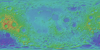
Moon Clementine UVVIS Warped Color Ratio Mosaic 200m
- Originators
- USGS Astrogeology Science Center
- Publisher
- USGS Astrogeology Science Center
- Publication Date
- 2008-08-15
- Abstract
- Product Information: This base represents the Clementine Ultraviolet/Visible (UVVIS) warped color-ratio mineral map. This was generated from the UVVIS mosaics using three spectral filters (415, 750, and 1000 nm) and which were previously warped (spatially adjusted) to the ULCN2005 control network. The mosaic is a composite in which the ratio of the 750/415nm bands is used for the red-channel brightness, 415/750nm for the blue channel, and the 750/1000nm ratio controls the green channel. Resolution of this mosaic is 200 meters per pixel (m). Color interpretations: The red channel represents areas that are low in titanium, or high in glass content, the green channel is sensitive to the amount of iron in the surface, and the blue channel reflects the surfaces with high titanium or bright slopes and albedos that are not compensated by using the image ratios. Lunar highlands appear red because they have accumulated glassy agglutinates produced during the bombardment of micrometeorites (maturation). Also red in the false-color image are pyroclastic deposits because of their naturally high-glass content. The yellow-green area in the mare is the combined effect of concentration of mafic minerals (green) and the glass in the soil produced by maturation (red). The blue unit in the mare is relatively higher in titanium compared to the mare unit to its immediate north. For more information on how the color ratio was derived, please see Lucy et al., 2000. Mission and Instrument Information: On January 25, 1994, the Deep Space Program Science Experiment (DSPSE), better known as Clementine, was launched from Vandenburg Air Force Base aboard a Titan IIG rocket, as a joint project between the and was jointly sponsored by the Ballistic Missile Defense Organization (BMDO) of the Dept of Defense and NASA. The objective of the mission was to test sensors and spacecraft components under extended exposure to the space environment and to make scientific observations of the Moon and a near-Earth asteroid (1620 Geographos). After two Earth fly-bys, lunar insertion was achieved on February 19th. Lunar mapping took place over approximately two months in two systematic mapping passes over the Moon. After the spectacular success of the Lunar mapping phase of the mission, Clementine suffered an on-board malfunction on May 7, 1994 that resulted in the activation of its altitude thrusters. This exhausted all the fuel for altitude control and left the spacecraft spinning at 80 revolutions per minute. The result of the malfunction prevented Clementine from performing the planned close fly-by of the near-Earth asteroid Geographos scheduled for August 1994. The main instrumentation on Clementine consisted of four cameras, one with a laser-ranging system. The cameras included an ultraviolet-visual (UVVIS) camera, a long-wavelength infrared (LWIR) camera, the laser-ranger (LIDAR) high-resolution (HIRES) camera, and a near-infrared (NIR) camera. The spacecraft also had two star tracker cameras (A-STAR, B- STAR), used mainly for attitude determination, but they also served as wide-field cameras for various scientific and operational purposes (PDS IMG, 2017). References: Lucey, P. G., Blewett, D. T., Taylor, G. J., & Hawke, B. R. (2000). Imaging of lunar surface maturity. Journal of Geophysical Research: Planets, 105(E8). https://doi.org/10.1029/1999JE001110 McEwen, A. S., & Robinson, M. S. (1997). Mapping of the Moon by Clementine. Advances in Space Research, 19(10), 1523-1533. https://doi.org/10.1016/S0273-1177(97)00365-7 Nozette, S., Rustan, P., Pleasance, L. P., Kordas, J. F., Lewis, I. T., Park, H. S., Priest, R. E., et al. (1994). The Clementine Mission to the Moon: Scientific Overview. Science, 266(5192), 1835-1839. https://www.doi.org/10.1126/science.266.5192.1835 Planetary Data Systems (PDS) Cartography and Imaging Sciences Node (IMG) (2017). Clementine Mission. https://pds-imaging.jpl.nasa.gov/portal/clementine_mission.html
- Purpose
- Color ratios serve to cancel out the dominant brightness variations in the image, generally caused by albedo variations and topographic shading. Color difference help to isolate the differences related to composition or mineralogy.
Contact and Distribution
- Format
- Global Mosaic, Mineral Map, Remote-sensing Data
- Access Constraints
- public domain
- Access Scope
- PDS
- Use Constraints
- Please cite authors
- Edition
- 2
- Edition Name
- Warped Color Ratio
- Supplemental Information
- http://www.lpi.usra.edu/meetings/lpsc2008/pdf/2337.pdf, https://pds.nasa.gov/ds-view/pds/viewProfile.jsp?dsid=CLEM1-L-H-5-DIM-MOSAIC-V1.0, https://agupubs.onlinelibrary.wiley.com/doi/10.1029/2003GL019406, https://pdsimage.wr.usgs.gov/archive/clem1-l-u-5-dim-uvvis-v1.0/cl_4001/document/volinfo.htm
- Native Data Set Environment
- ISIS v3
- Astrogeology Theme
- Mineral resources, Remote Sensing
- Mission Names
- Clementine
- Instrument Names
- UVVIS
- Online Package Link
- https://astrogeology.usgs.gov/search/map/moon_clementine_uvvis_warped_color_ratio_mosaic_200m
- External File Size
- 4.2 GB
- Online File Link
- https://planetarymaps.usgs.gov/mosaic/Lunar_Clementine_UVVIS_Warp_ClrRatio_Global_200m.tif
- Contact Address
- 2255 N. Gemini Drive
- Contact City
- Flagstaff
- Contact State
- AZ
- Contact Postal Code
- 86001
- Contact Email
- [email protected]
Data Status and Quality
- Time Period of Content (start)
- 1994-02-25
- Time Period of Content (stop)
- 1994-04-25
- Currentness Reference
- Ground condition
- Progress
- Complete
- Update Frequency
- None planned
- Logical Consistency
- This mosaic has been warped to the ULCN2005 control network.
- Completeness Report
- Gaps in the image are due to lack of coverage in one or more of the bands used in the color ratio.
- Process Description
- This was generated from the UVVIS warp mosaics using three spectral filters (415, 750, and 1000 nm). The mosaic is a composite in which the ratio of the 750/415nm bands is used for the red-channel brightness, 415/750nm for the blue channel, and the 750/1000nm ratio controls the green channel.
Lineage
- Process Date
- 2008-07-01
- Source Title
- Clementine warp mosaics
- Source Online Linkage
- {https://pds-imaging.jpl.nasa.gov/volumes/clementine.html,https://pds-imaging.jpl.nasa.gov/portal/clementine_mission.html}
- PDS Status
- PDS 3 Like
Geospatial Information
- Target
- Moon
- System
- Earth
- Minimum Latitude
- -90
- Maximum Latitude
- 90
- Minimum Longitude
- -180
- Maximum Longitude
- 180
- Direct Spatial Reference Method
- Raster
- Object Type
- Grid Cell
- Raster Row Count (lines)
- 27273
- Raster Column Count (samples)
- 54545
- Bit Type (8, 16, 32)
- 8
- Quad Name
- Radius A
- 1737400
- Radius C
- 1737400
- Bands
- 3
- Pixel Resolution (meters/pixel)
- 200.1341128
- Scale (pixels/degree)
- 151.5152
- Map Projection Name
- Simple Cylindrical
- Latitude Type
- Planetocentric
- Longitude Direction
- Positive East
- Longitude Domain
- -180 to 180