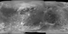
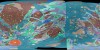
Jupiter Voyager and Galileo Global Mosaics

These Jupiter global mosaics utilized the best image quality and moderate resolution coverage supplied by Galileo SSI (Solid State Imaging instrument) and Voyager 1 and 2. The image processing was performed at USGS using the Integrated Software for Imagers and Spectrometers (ISIS) system. The image data was selected on the basis of overall image quality, reasonable input resolution, and availability of moderate viewing and sun angles for topography. The average input resolution was 1.0 kilometers/pixel. The resolution ranged from 60 km/pixel for gap fill up to 400 meters/pixel.
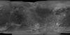
Callisto Galileo / Voyager Global Mercator Mosaic
Global MosaicThis global map of Callisto utilizes the best image quality and moderate resolution coverage supplied by Galileo SSI (Solid State Imaging instrument) and Voyager 1 and 2. The image processing was performed
Callisto Galileo/Voyager Global Mosaic 1km
Global Mosaic | Image | Raster Data | Remote-sensing DataThis global map of Callisto utilizes the best image quality and moderate resolution coverage supplied by Galileo SSI (Solid State Imaging instrument) and Voyager 1 and 2. This mosaic was prepared using
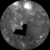
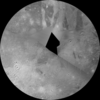
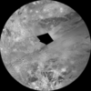
Callisto Galileo / Voyager North Polar Sterographic
Global MosaicThis global map of Callisto utilizes the best image quality and moderate resolution coverage supplied by Galileo SSI (Solid State Imaging instrument) and Voyager 1 and 2. The image processing was performed
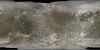
Callisto Galileo / Voyager Simple Cylindrical Global Map
Global MosaicThis global map of Callisto utilizes the best image quality and moderate resolution coverage supplied by Galileo SSI (Solid State Imaging instrument) and Voyager 1 and 2. The image processing was performed
Callisto Galileo / Voyager South Polar Stereographic
Global MosaicThis global map of Callisto utilizes the best image quality and moderate resolution coverage supplied by Galileo SSI (Solid State Imaging instrument) and Voyager 1 and 2. The image processing was performed
Callisto Voyager / Galileo Image Mosaic Globe
Global Mosaic | GlobeThe images used for the base of this globe were chosen from the best image quality and moderate resolution coverage supplied by Galileo SSI and Voyager 1 and 2 (Batson, 1987; Becker
Callisto Voyager / Galileo Image Mosaic Map
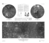
Global Mosaic 2002-01-02This sheet is one in a series of maps of the Galilean satellites of Jupiter at a nominal scale of 1:15,000,000. This series is based on data from the Galileo Orbiter Solid-State

Europa Voyager / Galileo Global Image Mosaic Map
Global Mosaic 2002-01-02This sheet is one in a series of maps of the Galilean satellites of Jupiter at a nominal scale of 1:15,000,000. This series is based on data from the Galileo Orbiter Solid-State
Europa Voyager - Galileo SSI Global Mosaic 500m
Global Mosaic | Raster Data | Remote-sensing Data 2010-01-01Product Information: This global map base of Europa utilizes the best image quality and moderate resolution coverage supplied by the Galileo SSI (Solid-State Imaging) instrument and Voyager 1 and 2. The image
Ganymede Controlled Color Photomosaic Map
Global Mosaic 2002-01-02This sheet is one in a series of maps of the Galilean satellites of Jupiter at a nominal scale of 1:15,000,000. This series is based on data from the Galileo Orbiter Solid-State
Ganymede Voyager / Galileo Global Mosaic Mercator
Global MosaicThis global map base of Ganymede utilizes the best image quality and moderate resolution coverage supplied by Galileo SSI (Solid State Imaging instrument) and Voyager 1 and 2. The image processing was
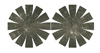
Ganymede Voyager Galileo Image Mosaic Globe
Global Mosaic | GlobeThe images used for the base of this globe were chosen from coverage supplied by the Galileo solid-state imaging (SSI) camera and Voyager 1 and 2 spacecraft. The monochrome and color data
Ganymede Voyager / Galileo North Polar Stereographic
Global MosaicThis global map base of Ganymede utilizes the best image quality and moderate resolution coverage supplied by Galileo SSI (Solid State Imaging instrument) and Voyager 1 and 2. The image processing was
Ganymede Voyager / Galileo Simple Cylindrical
Global MosaicThis global map base of Ganymede utilizes the best image quality and moderate resolution coverage supplied by Galileo SSI (Solid State Imaging instrument) and Voyager 1 and 2. The image processing was
Ganymede Voyager / Galileo South Polar Stereographic
Global MosaicThis global map base of Ganymede utilizes the best image quality and moderate resolution coverage supplied by Galileo SSI (Solid State Imaging instrument) and Voyager 1 and 2. The image processing was
Ganymede Voyager - Galileo SSI Color Global Mosaic 1.4km
Global Mosaic | Image | Raster Data | Remote-sensing DataProduct Information: This global mosaic of Ganymede utilizes the best image quality and moderate resolution coverage supplied by Galileo Solid-State Imaging (SSI) and Voyager 1 and 2. The image data was selected
Ganymede Voyager - Galileo SSI Global Mosaic 1km
Global Mosaic | Image | Raster Data | Remote-sensing DataProduct Information: This global mosaic of Ganymede utilizes the best image quality and moderate resolution coverage supplied by Galileo Solid-State Imaging (SSI) and Voyager 1 and 2. The image data was selected
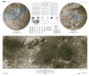
Global Geologic Map of Ganymede, SIM3237
Geologic Map | Global Mosaic 2014-02-11Ganymede is the largest satellite of Jupiter, and its icy surface has been formed through a variety of of impact cratering, tectonic, and possibly cryovolcanic processes. The history of Ganymede can be
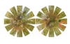
Io Galileo SSI Global Color Merge Mosaic 1km
Global Mosaic | Remote-sensing DataProduct Information: This global false color mosaic was constructed from low phase angle violet, green, and near-infrared (756 nanometer) images from orbits G2, E6, C9, and C21 of the Galileo spacecraft and
Io Galileo SSI Grayscale Global Mosaic 1km
Global Mosaic | Remote-sensing DataProduct Information: The best quality global monitoring images taken by the Galileo spacecraft's Solid-State Imaging (SSI) camera at spatial resolutions up to 1 kilometer per pixel (km) have been assembled here to
Io Galileo SSI / Voyager Color Merged Global Mosaic 1km
Global Mosaic | Remote-sensing DataTo present more information-rich views of Io, the global color derived from the Galileo color images was superimposed on the more detailed, higher resolution monochrome mosaics. The procedure adopted was to calculate

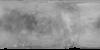
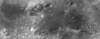
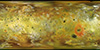
Io Voyager - Galileo Global Mosaic Rotation Animation
Global MosaicThis basemap of Jupiterâs moon Io was produced by combining the best images from both the Voyager 1 and Galileo Missions. Although the subjovian hemisphere of Io was poorly seen by Galileo,
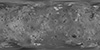
Io Voyager / Galileo Image Mosaic Globe
Global Mosaic | GlobeA global monochrome mosaic of the best resolution images from both Galileo and Voyager 1 was created that includes 51 Voyager 1 images with spatial resolutions sometimes exceeding the 1 km/pixel scale
Io Voyager - Galileo SSI False Color Global Mosaic 1km
Global Mosaic | Remote-sensing DataProduct Information: This new basemap of Jupiterâs moon Io was produced by combining the best images from both the Voyager 1 and Galileo Missions. Although the subjovian hemisphere of Io was poorly
Io Voyager - Galileo SSI Global Mosaic 1km
Global Mosaic | Remote-sensing DataProduct Information: Although the subjovian hemisphere of Io was poorly seen by Galileo, superbly detailed Voyager 1 images cover longitudes from 240ËW to 40ËW and the nearby southern latitudes. A global mosaic


