Io Voyager - Galileo SSI Global Mosaic 1km
- Primary Authors
- USGS Astrogeology Science Center
- Originators
- Planetary Data System
- Publisher
- USGS Astrogeology Science Center
- Abstract
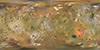
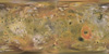
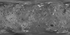
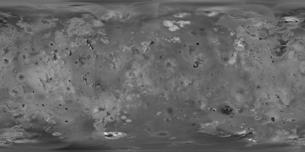
- Product Information: Although the subjovian hemisphere of Io was poorly seen by Galileo, superbly detailed Voyager 1 images cover longitudes from 240ËW to 40ËW and the nearby southern latitudes. A global mosaic of the best resolution images from both Galileo and Voyager 1 is shown here that includes 51 Voyager 1 images with spatial resolutions sometimes exceeding the 1 kilometer per pixel (km) scale of the final mosaic. While most of these images neatly overlie the Galileo coverage, the Voyager 1 images of regions west of 0Ë longitude appear displaced from the positions predicted from the control net derived from the solution of the combined Galileo and Voyager data set. We suspect that the discrepancy arises from regional topography west of the sub-Jupiter point, and have adjusted the positions of the Voyager 1 images (all acquired near the limb of Io) to match the best-fit geometry of Archinal et al. (2001). Solar illumination of these longitudes was from the east during the Voyager 1 flyby. Image resolutions range from 1.0 to 10 km along the equator, with the poorest coverage centered on longitude 50 W. Mission and Instrument Information: The Voyager I space craft launched September 5, 1977 and reached Jupiter on March 5th, 1979; Voyager 2 launched August 20, 1977 and made a similar encounter with Jupiter on July 9th, 1979. Galileo launched on October 18, 1989 from the Kennedy Space Center in Florida aboard the space shuttle Atlantis with the aim to study Jupiter and its moons. It arrived at Jupiter on December 7th, 1995 and ended when the spacecraft entered Jupiterâs atmosphere on September 21, 2003. Galileo made seven flybys of Io during its fourteen-year mission in the Jovian system. The Solid-State Imaging (SSI) experiment was designed to study Jupiter and itâs satellites using multi-spectral, high-resolution, charge-coupled device (CCD) camera. The camera was operated in eight filtered band passes from 350-1100nm, the eight -position filter wheel consisted of three broad-band filters: violet(404nm), green(559nm), and red(671nm). The borad-band filters allowed for the reconstruction of visible color photographs. The use of a CCD permitted the SSI to have an image geometry which was independent of brightness gradients, greater sensitivity to incident photons, and a wider spectral range than any camera previously flown on a planetary mission. References: Archinal, B. A., Davies, M. E., Colvin, T. R., Becker, T. L., Kirk, R. L., & Gitlin, A. R. (2001). An Improved Rand-USGS control network and size determination for IO. Paper presented at the 32nd Lunar and Planetary Science Conference, Lunar and Planetary Institute, Houston, TX. https://www.lpi.usra.edu/meetings/lpsc2001/pdf/1746.pdf Barth, B., Radebaugh, J., & Christiansen, E. H. (2009). Classification of Io's Paterae: Active vs Inactive. Paper presented at the 40th Lunar and Planetary Institute Science Conference, Lunar and Planetary Institute, Houston, TX. https://www.lpi.usra.edu/meetings/lpsc2009/pdf/2397.pdf Becker, T. L., & Geissler, P. E. (2005). Galileo Global Color Mosaics of Io. Paper presented at the 36th Lunar and Planetary Science Conference, Lunar and Planetary Institute, Houston, TX. http://www.lpi.usra.edu/meetings/lpsc2005/pdf/1862.pdf Belton, M. J. S., Klassen, K. P., Clary, M. C., Anderson, J. L., Anger, C. D., Carr, M. H., Chapman, C. R., et al. (1992). The Galileo Solid-State Imaging experiment. Space Science Reviews 60(1-4), 413-455. https://doi.org/10.1007/BF00216864 Geissler, P. E., McEwan, A. S., Keszthelyi, L., Lopes-Gautier, R., Granahan, J., & Simonelli, D. P. (1999). Global color variations on Io. Icarus, 140(2), 265â282. https://doi.org/10.1006/icar.1999.6128 Veeder, G. J., Davies, A. G., Matson, D. L., & Johnson, T. V. (2009). Io: Heat flow from dark volcanic fields. Icarus, 204(1), 239-253. https://doi.org/10.1016/j.icarus.2009.06.027 Williams, D. A., Keszthelyi, L. P., Crown, D. A., Yff, J. A., Jaeger, W. L., Schenk, P. M., Geissler, P. E., & Becker, T. L. (2011). Volcanism on Io: New insights from global geologic mapping. Icarus, 214(1), 91-112. https://doi.org/10.1016/j.icarus.2011.05.007
- Purpose
- The Io products update Voyager mission global maps with Galileo SSI data of superior resolution and geometric fidelity. The color mosaic improves on the previous product of Geissler (1999) using later, higher resolution images with better geometric control and a more consistent range of phase angles. These products have been used as a basis to map global geologic units, paterae, and volcanic fields and as a base map for formal planetary nomenclature. An animated globe produced from the merged mosaic is available from NASAâs Planetary Photojournal: http://photojournal.jpl.nasa.gov/catalog/PIA09257.
Contact and Distribution
- Format
- Global Mosaic, Remote-sensing Data
- Access Constraints
- public domain
- Access Scope
- PDS
- Use Constraints
- None
- Supplemental Information
- http://photojournal.jpl.nasa.gov/catalog/PIA09257
- Native Data Set Environment
- ISIS v3
- Astrogeology Theme
- Geographic Information System (GIS), Image Processing
- Mission Names
- Galileo, Voyager
- Instrument Names
- ISS, SSI
- Online Package Link
- https://astrogeology.usgs.gov/search/map/io_voyager_galileo_ssi_global_mosaic_1km
- External File Size
- 63 MB
- Online File Link
- https://planetarymaps.usgs.gov/mosaic/Io_GalileoSSI-Voyager_Global_Mosaic_1km.tif
- Contact Address
- 2255 N. Gemini Drive
- Contact City
- Flagstaff
- Contact State
- AZ
- Contact Postal Code
- 86001
- Contact Email
- [email protected]
- Currentness Reference
- Publication date
- Progress
- Complete
- Update Frequency
- None planned
- Logical Consistency
- All data were projected to a triaxial ellipsoid shape model using the best available Galileo control network (Archinal, B.A., Davies, M.E., Colvin, T.R., Becker, T.L., Kirk, R.L., Gitlin, A.R., 2001. An improved RAND-USGS control network and size determination for Io. Lunar Planet. Sci. XXXII. Abstract #1746). This network suffers from a lack of control points in the region of 320° to 20° (east) longitude. The Voyager 1 images of regions west of 0° longitude appeared displaced from the positions predicted from the control net derived from the solution of the combined Galileo and Voyager data set. We suspect that the discrepancy arises from regional topography west of the sub-Jupiter point, and have adjusted the positions of the Voyager 1 images (all acquired near the limb of Io) to match the best-fit geometry. Horizontal accuracy is nominally 1 pixel, translating to 1 kilometer in low latitude regions with good coverage.
- Completeness Report
- The color mosaic has no coverage within ~5° of the north and south poles. Smaller data gaps occur at both poles in both of the monochrome mosaics. The poles are filled in by interpolation in the merged mosaic. Each of the mosaics is made up of images with mixed resolution, with the poorest coverage on the Jupiter-facing hemisphere. Resolution of the color mosaic ranges from 1.3 to 21 km/pixel at the equator, while the monochrome and merged mosaics range from 1 to 10 km/pixel.
- Process Description
- PDS images were ingested into Integrated Software for Imagers and Spectrometers (ISIS, version 2) and were calibrated using the best end-of-mission calibration information, co-registered to subpixel precision, and map projected using the camera-pointing corrections of Archinal et al. (2001). A LunarâLambert limb-darkening correction was next performed, after having first determined that a coefficient of 0.7 was adequate for all three colors. Finally, the images were mosaicked together using a numerical procedure that reduces the mismatch at the seams (Soderblom, L.A., Edwards, K., Eliason, E.M., Sanchez, E.M., and Charette, M.P. 1978. Global color variations on the Martian surface. Icarus 34. doi:10.1016/0019-1035(78)90037-4). The merged mosaic was created by superimposing the color mosaic on the more detailed combined monochrome mosaic. The procedure adopted was to calculate color ratio images from the Galileo data and apply them to the monochrome mosaic, requiring that the color ratios of the composite images match the color ratios of the Galileo data. That is, the red brightness was computed as the product of the monochrome mosaic multiplied by the ratio of the Galileo 756 nm/GRN, and the blue brightness as the monochrome mosaic times the Galileo VIO/GRN ratio.
Lineage
- Process Date
- 2009-03-15
- Source Title
- Galileo and Voyager PDS Archives
- Source Online Linkage
- {https://pds-imaging.jpl.nasa.gov/volumes/galileo.html#gllSSIREDR,https://pds-imaging.jpl.nasa.gov/volumes/voyager.html#vgrISSEDR-J,http://pds-imaging.jpl.nasa.gov/portal/galileo_mission.html,https://pds-imaging.jpl.nasa.gov/portal/voyager_mission.html}
- PDS Status
- PDS 3 Like
- Attribute Accuracy Report
- Accurate to Control Net
- Horizontal Positional Accuracy Report
- Accurate to Control Net
Geospatial Information
- Target
- Io
- System
- Jupiter
- Minimum Latitude
- -90
- Maximum Latitude
- 90
- Minimum Longitude
- -180
- Maximum Longitude
- 180
- Direct Spatial Reference Method
- Raster
- Object Type
- Grid Cell
- Raster Row Count (lines)
- 5723
- Raster Column Count (samples)
- 11445
- Bit Type (8, 16, 32)
- 8
- Quad Name
- Radius A
- 1821460
- Radius C
- 1821460
- Bands
- 1
- Pixel Resolution (meters/pixel)
- 1000
- Scale (pixels/degree)
- 31.79
- Map Projection Name
- Simple Cylindrical
- Latitude Type
- Planetocentric
- Longitude Direction
- Positive West
- Longitude Domain
- -180 to 180