Product Information: This digital elevation model (DEM) was initially created as an assessment tool for the entry, descent, and landing (EDL) analysis conducted by the Mars Science Laborarory (MSL)…
We have created 39 regional semi-controlled CTX mosaics at 5m/pixel for the 2015 proposed Mars Human Exploration zones. They are individually available for download in GeoTiff format from the "Online…
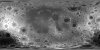
Product Information: The Lunar Orbiter Laser Altimeter (LOLA) and SELenological and Engineering Explorer (SELENE) Kaguya Teams have created this shaded relief of the improved lunar digital elevation…
Product Information: The Lunar Orbiter Laser Altimeter (LOLA) and SELenological and Engineering Explorer (SELENE) Kaguya Teams have created an improved lunar digital elevation model (DEM) covering…
Product Information: This digital elevation model (DEM) is based on data from the Lunar Orbiter Laser Altimeter (LOLA; Smith et al., 2010), an instrument on the National Aeronautics and Space Agency…
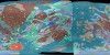
Ganymede is the largest satellite of Jupiter, and its icy surface has been formed through a variety of of impact cratering, tectonic, and possibly cryovolcanic processes. The history of…
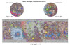
These maps are a series of geologic maps that cover the entire Moon at a scale of 1:5,000,000 originally created in the 1970's. Because of increasing emphasis on lunar studies from recent orbital…
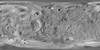
Product Information: This mosaic of Phobos was created by compiling updated versions of Viking high-resolution mosaics and selecting the best high-resolution images from other spacecraft to…
Product Information: This is a colorized shaded-relief of a original polar digital elevation model (DEM) from the Lunar Orbiter Laser Altimeter (LOLA; Smith et al., 2010), an instrument on the…
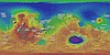
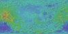
Product Information: This global image map of Mars has a resolution of 256 pixels/degree (scale approximately 232 meters per pixel (m) at the equator). The colorized mosaic was completed by NASA…