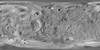
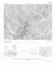
Products

366 Results Collapse
Phobos Viking Global Mosaic 5m v1 thumbnail

Phobos Viking Global Mosaic 5m v1

application/isis 99 MBJun 01 2012

Product Information: This mosaic of Phobos was created by compiling updated versions of Viking high-resolution mosaics and selecting the best high-resolution images from other spacecraft to…

Mars Viking Colorized Global Mosaic 232m v2 thumbnail

Mars Viking Colorized Global Mosaic 232m v2

application/isis 12 GBFeb 02 2009

Product Information: This global image map of Mars has a resolution of 256 pixels/degree (scale approximately 232 meters per pixel (m) at the equator). The colorized mosaic was completed by NASA…

Mars 15M Geologic Map GIS Renovation thumbnail

Mars 15M Geologic Map GIS Renovation

application/zip 15 MBMar 01 2006

A digital adaptation of the hard-copy Viking Orbiter-based geologic maps of Mars. The western equatorial region was originally mapped by David H. Scott and K. L. Tanaka (USGS I-1802-A, 1986, 1:15M…

Viking MDIM2.1 Grayscale Global Mosaic 232m thumbnail

Viking MDIM2.1 Grayscale Global Mosaic 232m

application/isis 4 GB

This global image map of Mars has a resolution of 256 pixels/degree (scale approximately 231 m/pixel at the equator). The black-and-white mosaic is processed to emphasize local topographic features.…

Mars Viking Lander 2 Rectified Photomosaics thumbnail

Mars Viking Lander 2 Rectified Photomosaics

application/pdf 9 MBNov 23 2023

Mars Viking Lander 1 Rectified Photomosaics thumbnail

Mars Viking Lander 1 Rectified Photomosaics

application/pdf 9 MBNov 21 2023

Project Pages

3 Results Collapse
Mars Global Digital Image Mosaic MDIM 2.1 thumbnail

Mars Global Digital Image Mosaic MDIM 2.1

http://astrogeology.usgs.gov/maps/mdim-2-1

This global image map of Mars has a resolution of 256 pixels/degree (scale approximately 231 m/pixel at the equator). The black-and-white mosaic is processed to emphasize local topographic…

Mars Control Networks thumbnail

Mars Control Networks

http://astrogeology.usgs.gov/maps/control-networks/mars

The U.S. Geological Survey has recently completed a final revised version of its 231 m/pixel global Viking image mosaic of Mars that has substantially improved geodetic accuracy compared to versions…

Mars Dunes

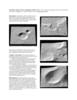
http://astrogeology.usgs.gov/geology/mars-dunes

Sand dunes are among the most widespread aeolian features present on Mars, serving as unique indicators of the interaction between the atmosphere and surface. On a planetary body, dunes accumulate…

Documents

8 Results Collapse
ISPRS 1998 Stereogrammetric Mapping of Mars thumbnail

ISPRS 1998 Stereogrammetric Mapping of Mars

application/pdf 65 kB

The Viking Orbiters acquired quality stereo coverage of a significant fraction of Mars in 1976-1980. Several groups have been using this stereo coverage to produce global and regional scale…

ISPRS 1998 Reanalysis of the Viking Control Point Network: Implications for global Shape and Coordinate Systems of Mars thumbnail

ISPRS 1998 Reanalysis of the Viking Control Point Network: Implications for global Shape and Coordinate Systems of Mars

application/pdf 64 kB

We recomputed the Viking Mars Control Point Network and derived Mars-fixed 3-dimensional coordinates of 3739 selected, globally distributed landmarks. The Mars Pathfinder coordinates and data from…

ISPRS 1999 Assessment of Published Viking Orbiter DEMs derived from Stereo Photogrammetry using MOLA Data thumbnail

ISPRS 1999 Assessment of Published Viking Orbiter DEMs derived from Stereo Photogrammetry using MOLA Data

application/pdf 2 MB

Described the exciting results which have been obtained from the initial set of mainly Northern hemispheric laser altimetry tracks from the MOLA instrument known as the SPO-1 phase. More recently has…

ISPRS 1999 A Database of Viking Orbiter Image Coverage of Mars for Cartographic and Scientific Use thumbnail

ISPRS 1999 A Database of Viking Orbiter Image Coverage of Mars for Cartographic and Scientific Use

application/pdf 2 MB

Viking Orbiters 1 and 2 collectively returned more than 46,000 images of Mars between 1976 and 1980. Numerous observation sequences with different objectives resulted in an extremely complex and…

ISPRS 1999 A New Viking-Based Precise Global Map of Mars thumbnail

ISPRS 1999 A New Viking-Based Precise Global Map of Mars

application/pdf 10 kB

We present a new global map of Mars based on images taken by the Viking Orbiters. Precise image position information and camera pointing data, needed to produce this map, were derived from a recent…

ISPRS 2001 Improved 3D Mars Control Net from a Combined Adjustment of Viking Images and Mars Orbiter Laser Altimeter Data thumbnail

ISPRS 2001 Improved 3D Mars Control Net from a Combined Adjustment of Viking Images and Mars Orbiter Laser Altimeter Data

application/pdf 44 kB

The current global spatial control net of Mars provides the geodetic basis for an orthoimage map composed of image data sets obtained from VIKING missions from 1976 to 1980. This map is not…

ISPRS 2003 Mapping Mars with Landmark Templates thumbnail

ISPRS 2003 Mapping Mars with Landmark Templates

application/pdf 557 kB

Viking Orbiter, MOC and MOLA data are being used to construct three dimensional landmark templates on Mars which can be aligned with a variety of data types for navigation on future missions and…

ISPRS 2004 Mars Digital Image Model (MDIM 2.1) Control Network thumbnail

ISPRS 2004 Mars Digital Image Model (MDIM 2.1) Control Network

application/pdf 382 kB

Positional control for MDIM 2.1 comes from a new geodetic/photogrammetric solution of the global Mars Mariner 9 and Viking image control network. The details of this network solution are described…