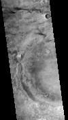

CTX Orthoimage of Candidate Mars 2020 Landing Site McLaughlin Center
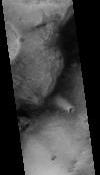
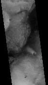
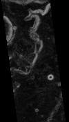
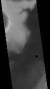
This product represents an orthorectified CTX image within part of a candidate landing site for the Mars2020 mission. The CTX image from which this product was derived is one member of a stereopair. Together, the images in the stereopair were used to construct a digital terrain model (DTM). The original images in the stereopair were then orthorectified using the DTM.
This orthorectified image was produced as part of an effort to characterize terrain within candidate landing ellipses for the Mars2020 mission and to aid entry, descent, and landing simulations for the mission. The parent DTM was constructed from a pair of CTX images using the stereo photogrammetry software SOCET SET® (BAE Systems).
The DTM from which this product was derived and the other orthorectified member of the corresponding stereopair are available under the "Related Products" section on the right of this page.
Preferred Citation: R.L. Fergason, T.M. Hare, R.L. Kirk, S. Piqueux, D.M. Galuzska, M.P. Golombek, R.E. Otero, and B.L. Redding, 2017, "Mars 2020 Landing Site Evaluation: Slope and Physical Property Assessment," 48th Lunar and Planetary Science Conference, held 20-24 March 2017, at The Woodlands, Texas. LPI Contribution No. 1964, id.2163.
Reference: R.L. Fergason, R.L. Kirk, G. Cushing, D.M. Galuszka, M.P. Golombek, T.M. Hare, E. Howington-Kraus, D.M. Kipp, B.L. Redding, 2016, "Analysis of Local Slopes at the InSight Landing Site on Mars," Space Sci. Rev., 1572-9672, doi:10.1007/s11214-016-0292-x.
- Publication Date
- 20 March 2017
- Author
- Robin L. Fergason
- Originator
- R.L. Fergason, T.M. Hare, R.L. Kirk, S. Piqueux, D.M. Galuzska, M.P. Golombek, R.E. Otero, B.L. Redding
- Group
- Added to Astropedia
- 27 October 2017
- Modified
- 8 May 2019
General
- Purpose
This orthorectified image was produced as part of an effort to characterize terrain within candidate landing ellipses for the Mars2020 mission and to aid entry, descent, and landing simulations for the mission.
- Geospatial Data Presentation Form
- Raster Data, Landing Site Map
- Edition
- 1
- Online Linkage
- https://planetarymaps.usgs.gov/mosaic/mars2020_landing_site_dtm/F01_036358_2020_XN_22N022W_6m_ORTHO.tif
- Native Data Set Environment
- ISIS v3
- Supplemental Information
- https://dx.doi.org/10.1007/s11214-016-0292-x
Keywords
- System
- Mars
- Target
- Mars
- Theme
- Photogrammetry, Landing sites
- Mission
- Mars Reconnaissance Orbiter
- Instrument
- CTX
- Search Terms
- orthoimage, orthorectified, Mars2020, Mars 2020, landing site
Contact and Distribution
- Access Constraints
- Public Domain
- Use Constraints
- Please Cite Authors
Data Status and Quality
- Currentness Reference
- Publication date
- Progress
- Complete
- Update Frequency
- None planned
- Process Description
The CTX image from which this product was derived is one member of a stereopair. The members of the stereopair were first radiometrically calibrated using the USGS ISIS3 software. The calibrated images were then stretched to enhance the clarity of features in the scene and then resampled to 8 bits per pixel. These pre-processed images were then used to construct a digital terrain model (DTM) using the stereo photogrammetry software SOCET SET® (BAE Systems). The original stretched and resampled images were then orthorectified using the DTM.
See Fergason et al. (2016) for a detailed processing description.
- Horizontal Positional Accuracy Value
- 100
- Horizontal Positional Accuracy Report
- Accurate to Control Net
- Vertical Positional Accuracy Value
- 30
- Vertical Positional Accuracy Report
- Accurate to Control Net
Lineage
- Source PDS Archive
- Mars Reconnaissance Orbiter
- Source Originator
- Planetary Data System (PDS) Experimental Data Record (EDR)
- Source Title
- CTX
- Source Online Linkage
- http://pds-imaging.jpl.nasa.gov/volumes/mro.html
- Type of Source Media
- Online
Geospatial Information
- Feature Target
- Mars
- Minimum Latitude
- 21.541022538787
- Maximum Latitude
- 22.311671924851
- Minimum Longitude
- 337.54095479
- Maximum Longitude
- 338.16283712
- Direct Spatial Reference Method
- Raster
- Object Type
- Pixel
- Lines (pixels)
- 7543
- Samples (pixels)
- 6087
- Bit Type
- 8
- Quad Name
- MC-11
- Radius A
- 3396190
- Radius C
- 3376200
- Bands
- 1
- Pixel Resolution (meters/pixel)
- 6.0561370714705
- Scale (pixels/degree)
- 9787.54226065
- Horizontal Coordinate System Units
- Meters
- Map Projection Name
- Equirectangular
- Latitude Type
- Planetocentric
- Longitude Direction
- Positive East
- Longitude Domain
- 0 to 360