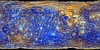
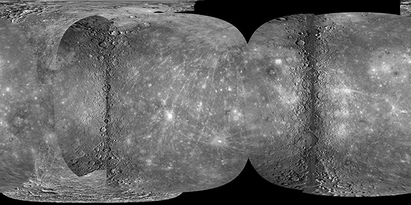
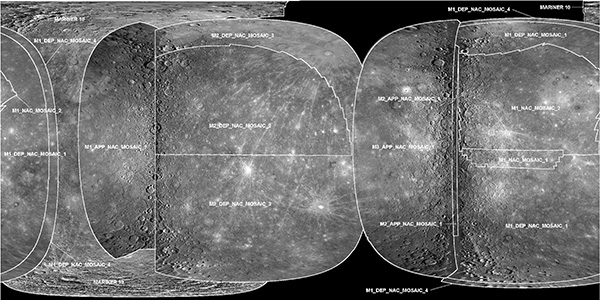
This mosaic represents the best geodetic map of Mercury's surface to date. MESSENGER's three flybys alone provide 90.90% of the data in the global mosaic (see Table above). Although MESSENGER went in to safe mode during the third flyby, the approach imaging was acquired and contributes ~6.82% additional coverage from earlier versions. Only the poles remain to be imaged, some of which are in permanent shadow.
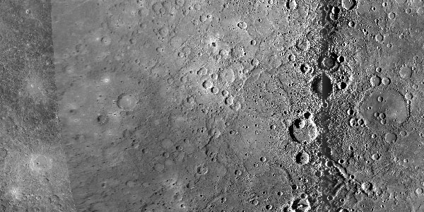
The mosaic is comprised entirely of flyby data (Mariner 10 also had three Mercury flybys). The images were collected with large variations in resolution (see table below) and with varying lighting conditions while the spacecraft was traveling at speeds greater than 2 km/sec. It has been photometrically corrected using a Hapke-Henyey-Greenstein photometric model. Pixel density values are in I/F reflectance units. The darker vertical regions to left and right of center are coverage provided by images near or at the terminator (low Sun). These areas required special processing to retain illuminated features that are otherwise eliminated at incidence angles greater than 90° when the photometric model is applied.
The "smeared" data at the outer overlapping edges of the observations are limb images. These images are at high emission angles resulting in distortion within a derived map projection. The limb data are trimmed at lower emission angles in order to visually limit this effect. The mosaic is provided at 500 meters/pixel (~85.17 pixels/degree) resolution, planetocentric latitudes with a center latitude of 0.0., and -180 to +180 positive east longitudes with a center longitude of 0.0.
Coverage Percentages for MESSENGER and Mariner 10
| Data Set | Surface Area (km2) | Coverage (%) |
|---|---|---|
| Mercury | 74,822,795 | 100.0 |
| M1+M2 | 64,323,084 | 85.97 |
| M1+M2+M3 | 68,014,600 | 90.90 |
| M3 New Coverage | 3,691,516 | 4.93 |
| Mariner 10 | 32,179,875 | 43.01 |
| M1+M2+M3+M10 | 73,118,095 | 97.72 |
| M10 contribution to mosaic | 5,103,495 | 6.82 |
Control Network
There are 13 total observation sequences from all three MESSENGER flybys included in the control network. The figure above outlines of the locations of selected MDIS image observations used in the mosaic. The MDIS/NAC image observations Table (above) shows the breakdown of these observations in terms of number, resolution and inclusion in the mosaic.
The existing Mariner 10 base map provided a ground "truth" for the MESSENGER control network. Select MESSENGER images were tied to the Mariner 10 base at seven different ground truth locations. Using ISIS3 software, 5,301 control points (18,834 measurements) were selected in 886 MDIS narrow-angle camera (NAC) images. Highly specialized bundle block adjustment software was used to minimize image boundary mismatches.
The maximum RMS error for the global control is 3.48 pixels. The average RMS error is 0.2 pixels. Pixel density values are in I/F reflectance units. Absolute errors of the MESSENGER bundle adjustment are relative to the base map as reported to be ~25 km [Robinson 1999]. Hun Kal, a small crater defining the longitude system of Mercury, is within ~2.257 km of its predicted position of 20°W longitude.
MDIS-NAC Image Observations
| Observation | Total Images | Images in Global Mosaic | Average Resolution (m/pxl) | Minimum Resolution (m/pxl) | Maximum Resolution (m/pxl) |
|---|---|---|---|---|---|
| M1_APP_NAC_MOSAIC_1 | 38 | 38 | 511 | 470 | 553 |
| M1_DEP_NAC_MOSAIC_1 | 87 | 87 | 532 | 473 | 590 |
| M1_DEP_NAC_MOSAIC_2 | 66 | 0 | 625 | 573 | 677 |
| M1_DEP_NAC_MOSAIC_2 | 66 | 0 | 625 | 573 | 677 |
| M1_DEP_NAC_MOSAIC_3 | 43 | 0 | 806 | 764 | 847 |
| M1_DEP_NAC_MOSAIC_4 | 36 | 36 | 862 | 822 | 903 |
| M1_NAC_MOSAIC_1 | 68 | 68 | 144 | 116 | 171 |
| M1_NAC_MOSAIC_2 | 96 | 96 | 281 | 236 | 325 |
| M2_APP_NAC_MOSAIC_1 | 27 | 27 | 461 | 426 | 496 |
| M2_DEP_NAC_MOSAIC_1 | 35 | 0 | 132 | 99 | 166 |
| M2_DEP_NAC_MOSAIC_2 | 175 | 175 | 254 | 162 | 347 |
| M2_DEP_NAC_MOSAIC_3 | 86 | 86 | 578 | 522 | 633 |
| M2_DEP_NAC_MOSAIC_4 | 67 | 0 | 671 | 621 | 720 |
| M3_APP_NAC_MOSAIC_1 | 62 | 58 | 1983 | 396 | 3570 |
| Total | 886 | 671 | |||
References
- K. J. Becker, M. S. Robinson, T. L. Becker, L. A. Weller, S. Turner, L. Nguyen, C. Selby, B. W. Denevi, S. L. Murchie, R. L. McNutt, S. C. Solomon, Near Global Mosaic of Mercury, Eos, Vol. 90, Number 52, 29 December 2009, Fall Meet. Suppl., Abstract P21A-1189.
- Robinson, Mark S., et al., (1999) Revised control network for Mercury, Journal of Geophysical Research, 104(E12) Pages 30,847-30,852.
- Becker, Kris J, et al., (2008) A New Global Mosaic of Mercury, Eos Trans. AGU, 89(53), Fall Meet. Suppl., Abstract U21A-0015.
- Anderson, Jeffery A, et al., (2004) Modernization of the Integrated Software for Imagers and Spectrometers, Lunar and Planetary Science XXXV, Abstract 2039.