Products

983 Results Collapse
Venus Geologic Map of the Artemis Chasma Quadrangle (V-48) thumbnail

Venus Geologic Map of the Artemis Chasma Quadrangle (V-48)

application/pdf 39 MBFeb 10 2010

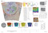
Artemis, named for the Greek goddess of the hunt, represents an approximately 2,600 km diameter circular feature on Venus, and it may represent the largest circular structure in our solar system.…

Venus Geologic Map of the Greenaway Quadrangle (V-24) thumbnail

Venus Geologic Map of the Greenaway Quadrangle (V-24)

application/pdf 27 MBFeb 10 2010

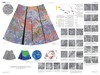
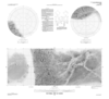
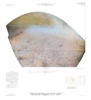
The Greenaway quadrangle (V-24; lat 0 degrees -25 degrees N., long 120 degrees -150 degrees E.), Venus, derives its name from the impact crater Greenaway, centered at lat 22.9 degrees N., long 145.1…

Venus Geologic Map of the Lakshmi Planum Quadrangle (V-7) thumbnail

Venus Geologic Map of the Lakshmi Planum Quadrangle (V-7)

application/pdf 30 MBFeb 10 2010

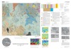
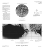
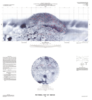
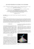
The Lakshmi Planum quadrangle is in the northern hemisphere of Venus and extends from lat 50 degrees to 75 degrees N., and from long 300 degrees to 360 degrees E. The elevated volcanic plateau of…

Moon Clementine UVVIS 5 Band Warped Image Mosaic 200m v1 thumbnail

Moon Clementine UVVIS 5 Band Warped Image Mosaic 200m v1

application/isis 14 GBMar 01 2008

Product Information: The Clementine Ultraviolet/Visible (UVVIS) mosaic of Earth's Moon is a radiometrically and geometrically controlled, photometrically modeled global Mosaicked Digital Image Model…

Dione Pictorial Map and Controlled Photomosaic thumbnail

Dione Pictorial Map and Controlled Photomosaic

application/pdf 4 MBDec 31 1992

Iapetus Pictorial Map and Controlled Photomosaic thumbnail
Mimas Pictorial Map thumbnail

Mimas Pictorial Map

application/pdf 4 MBDec 31 1992

Tethys Pictorial Map and Controlled Photomosaic thumbnail
Triton Pictorial Map thumbnail

Triton Pictorial Map

application/pdf 4 MBDec 31 1992

Project Pages

6 Results Collapse

Documents

32 Results Collapse
ISPRS 2003 Mapping Mars with Landmark Templates thumbnail

ISPRS 2003 Mapping Mars with Landmark Templates

application/pdf 557 kB

Viking Orbiter, MOC and MOLA data are being used to construct three dimensional landmark templates on Mars which can be aligned with a variety of data types for navigation on future missions and…

ISPRS 2003 Visual Calculus of Perceptual Fribble? World Maps with Constant Scale Edges: A Novel Projection Method, Well-Suited to our Era thumbnail

ISPRS 2003 Visual Calculus of Perceptual Fribble? World Maps with Constant Scale Edges: A Novel Projection Method, Well-Suited to our Era

application/pdf 3 MB

I introduce world maps with constant scale edges [cse], and show how cse encompasses both conventional projections and a new class of maps—world maps with constant scale natural boundaries [csnb].…

ISPRS 2004 Multi-Image Shape from Shading, Derivation of Planetary Digital Terrain Models Using Clementine Images thumbnail

ISPRS 2004 Multi-Image Shape from Shading, Derivation of Planetary Digital Terrain Models Using Clementine Images

application/pdf 627 kB

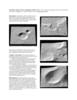
In many cases, the derivation of high-resolution digital terrain models (DTMs) from planetary surfaces using only conventional digital image matching is a problem. The matching methods need at least…

ISPRS 2004 Combining Mars Data in GRASS GIS for Geologic Mapping thumbnail

ISPRS 2004 Combining Mars Data in GRASS GIS for Geologic Mapping

application/pdf 662 kB

Geo Information Systems (GIS) are standard tools in the Earth sciences whenever different geographic data sets must be combined. GIS became increasingly popular in the field of planetary research as…

ISPRS 2004 Cartography of the Saturnian Satellites thumbnail

ISPRS 2004 Cartography of the Saturnian Satellites

application/pdf 1 MB

We have re-measured control points and re-computed a control point network for Saturn’s satellite Dione. Our network is based on 16 images (obtained by the narrow-angle cameras of Voyager I and…

ISPRS 2004 The Mapping Performance of the HRSC / SRC in Mars Orbit thumbnail

ISPRS 2004 The Mapping Performance of the HRSC / SRC in Mars Orbit

application/pdf 2 MB

The images obtained by the HRSC (High Resolution Stereo Camera) on Mars Express show excellent potential for topographic mapping of the planet. The derived stereo models agree with topographic data…

ISPRS 2004 Mars Digital Image Model (MDIM 2.1) Control Network thumbnail

ISPRS 2004 Mars Digital Image Model (MDIM 2.1) Control Network

application/pdf 382 kB

Positional control for MDIM 2.1 comes from a new geodetic/photogrammetric solution of the global Mars Mariner 9 and Viking image control network. The details of this network solution are described…

ISPRS 2004 Topographic Mapping of Mars from Hectometer to Micrometer Scales thumbnail

ISPRS 2004 Topographic Mapping of Mars from Hectometer to Micrometer Scales

application/pdf 2 MB

We describe USGS topomapping of Mars at resolutions from 100 m to 30 µm with data from the latest spacecraft missions. Analysis of NASA 2001 Mars Odyssey Thermal Emission Imaging System (THEMIS)…

ISPRS 2004 Combined Bundle Adjustment of MOC Stereo Images and MOLA Altimetry Data for Precise Mars Topographic Mapping thumbnail

ISPRS 2004 Combined Bundle Adjustment of MOC Stereo Images and MOLA Altimetry Data for Precise Mars Topographic Mapping

application/pdf 184 kB

Launched in 1996, Mars Global Surveyor (MGS) carries two types of mapping equipments: Mars Orbiter Laser Altimeter (MOLA) and Mar Orbiter Camera (MOC). MOLA collects accurate laser altimetry data…

ISPRS 2004 True-3D Visualization of the Martian Surface Based on Lenticular Foil Technology using HRSC Imagery thumbnail

ISPRS 2004 True-3D Visualization of the Martian Surface Based on Lenticular Foil Technology using HRSC Imagery

application/pdf 389 kB

Following the conceptual idea "from 3D camera to 3D view", the production of true-3D image maps for the glasses-free stereoviewing of parts of the Martian surface, is described. The image data have…