At the development of a mathematical basis of cartographic products the problems of selection of a reference-surface system, system of coordinates, and also selection and elaboration of cartographic…
Described the exciting results which have been obtained from the initial set of mainly Northern hemispheric laser altimetry tracks from the MOLA instrument known as the SPO-1 phase. More recently has…
The SPICE ancillary information system developed at NASA's Jet Propulsion Laboratory offers a flexible, multimission suite of data containers and related software--a subroutine library--for…
The map sheet "MARS 1:2,000,000 Mouth of Ares and Tiu Valles" presents the mapped area on the planet's northern hemisphere in two different cartographic categories. The Image Map, portraying the…
We describe a cartographic project to re-process and semi-automatically stereo match Mariner 10 vidicon stereo pair images. Three different patch-based digital stereo matching algorithms have been…
The RAND control network of Mars was begun during the Mariner 9 mission, and it has been expanded and improved since then. The network is based on measurements of points made on images taken by the…
The Mars Orbiter Laser Altimeter (MOLA) on the Mars Global Surveyor (MGS) mission will produce a precision global geodetic control network for Mars of 30,000 - 50,000 points which will be accurate to…
Viking Orbiter images were reprocessed using new techniques to produce a precision controlled, photomosaic map of the Mars Pathfinder landing site prior to landing. The difference between the…
Imagery is the major source for our current understanding of the geologic and climatologic evolution of Mars. It has the potential to drastically enhance our knowledge in the future and is an…
The Imager for Mars Pathfinder (IMP) obtained 5 full panoramic sets of images, varying in color and stereo coverage and degree of data compression, from the highly compressed First Look to the…
Our project aims to automate Mars mapping and localization using robotic stereo and descent imagery. Stereo vision is a wellstudied domain. However, most efforts aim only at a general scene; little…
In a previous research effort a terrain partition framework was defined allowing the partition of the landscape of Valles Marineris chasma (an elongated steep-sided depression located in Mars) to…
Following the conceptual idea "from 3D camera to 3D view", the production of true-3D image maps for the glasses-free stereoviewing of parts of the Martian surface, is described. The image data have…
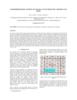
In general, maps should answer a very simple question of its reader: "what's there" and „where is something”? For planetary maps, the answer is more difficult, because (1) in some cases even map…
Crater Size-Frequency Distributions (SFD) on planetary surfaces are crucial to dating the geological age. On the Moon they have been employed together with radioactive K-Ar techniques to determine…
The High Resolution Stereo Camera (HRSC) on board of the European space mission Mars Express provides multispectral digital image data in high resolution as well as the systematic stereo coverage of…
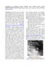
CHARACTERIZATION OF IMPACT EJECTA DEPOSITS FROM METEOR CRATER, ARIZONA. T. A. Gaither, J. J. Hagerty, J. F. McHone, and H. E. Newsom, U.S. Geological Survey, Astrogeology Science Center, 2255 N.…
MULTI-DIMENSIONAL CHARACTERIZATION OF IMPACT EJECTA DEPOSITS FROM METEOR CRATER, AZ. T. A. Gaither, J. J. Hagerty, S. E. Clark, T. M. Hare, R. K. Hayward, H. E. Newsom, S. P. Wright, and J. McHone,…