Lunar and Planetary Cartographic Catalog
Download
Browse
(jpg) 512 x 512
Original
(pdf) 5 MB
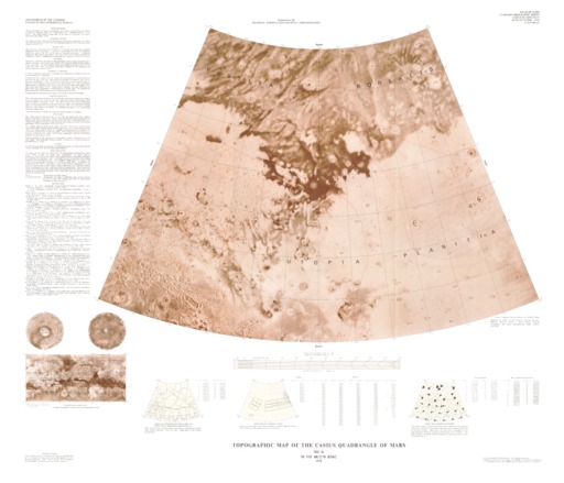
Mars Topographic Map of the Casius Quadrangle
Mimetype
application/pdf
Filename
Mars-Topographic-Map-of-the-Casius-Quadrangle.pdf
Publisher
USGS Astrogeology Science Center
Publication Date
17 October 1978
Originator
Group
RPIF
Added to Astropedia
3 May 2016
Modified
22 June 2021
General
Geospatial Data Presentation Form
Regional Mosaic
Series Id
1119
Keywords
Target
Mars
Theme
Cartography
,
Remote Sensing
,
Topography
Mission
Contact and Distribution
Access Instructions
1 map : col. ;49 x 70 cm.
Geospatial Information
Minimum Latitude
30
Maximum Latitude
65
Minimum Longitude
60
Maximum Longitude
120
Quad Name
MC-6
FGDC:
xml metadata
Ancillary Data
Metadata
(xml) 966 bytes
Related Products
Mars Shaded Relief Map of the Argyre Quadrangle
1
…
7
8
9
10
ISIS
Planetary Nomenclature
Map a Planet 2
PDS Cartography and Imaging Science Node
RPIF
Photogrammetry Guest Facility
PILOT
MRCTR GIS Lab