Mercury MESSENGER MDIS Volatile Loss DTM
- Primary Authors
- Colin Dundas
- Originators
- USGS Astrogeology Science Center
- Publisher
- USGS Astrogeology Science Center
- Abstract
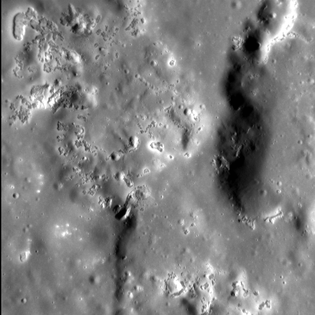
- Product Information: The discovery of hollows on Mercury remains one of the most surprising scientific findings by MESSENGER. Hollows are sharp-edged, irregular, rimless pits that are often surrounded by bright haloes (Blewett, D. T. et al., 2013) and form primarily in terrains exhibiting reflectance values lower than that of the global average [e.g., 2â5]. Hollows are interpreted to represent volatile-loss landforms on the basis of geomorphic and remotely sensed geochemical observations [e.g., 1,2,4,6â10]. Observations of topography, specifically the relationships of hollows to their surroundings, can be used to investigate hollow formation. Provided here is a set of digital terrain models (DTMs) that were constructed to examine the topographic settings of landforms around Mercury's hollows. Reference citation numbers correspond with the citation numbers listed below. Mission and Instrument Information: The MErcury Surface, Space Environment, Geochemistry, and Ranging (MESSENGER) spacecraft launched on August 3rd, 2004, it entered orbit around Mercury on March 11, 2011 and ended its mission on April 30th, 2015 when it deliberately plunged into the surface or Mercury. MESSENGER was the first spacecraft to orbit Mercury and had the primary goal of studying the geology, magnetic field, and chemical composition of the planet. The science payload onboard MESSENGER included: Mercury Dual Imaging System (MDIS), Gamma-Ray Spectrometer (GRS), Neutron Spectrometer (NS), X-ray Spectrometer (XRS), Mercury Laser Altimeter (MLA), Mercury Atmospheric and Surface Composition (MACS), Energetic Particle and Plasma Spectrometer (EPPS), and Radio Science experiment (RS). The MDIS instrument suite consists of wide-angle (WAC) and narrow-angle imagers (NAC) situated on a pivot platform that enables the instruments to be pointed in specified directions. Reference: [1] Blewett, D. T. et al. (2011). Hollows on Mercury: MESSENGER Evidence for Geologically Recent Volatile-Related Activity. Science, 333, 1856â1859. https://doi.org/10.1126/science.1211681 [2] Blewett, D. T. et al. (2013). Mercury's hollows: Constraints on formation and composition from analysis of geological setting and spectral reflectance. Journal of Geophysical Research: Planets, 118, 1013â1032. https://doi.org/10.1029/2012JE004174 [5] Denevi, B. W. et al. (2009). The Evolution of Mercuryâs Crust: A Global Perspective from MESSENGER. Science, 324(5927), 613-618. https://doi.org/10.1126/science.1172226 [12] Helbert, J. et al. (2013). Visible and near-infrared reflectance spectra of thermally processed synthetic sulfides as a potential analog for the hollow forming materials on Mercury. Earth and Planetary Science Letters, 369-370, 233-238. https://doi.org/10.1016/j.epsl.2013.03.045 [6] Nittler, L. R. et al. (2011). The Major-Element Composition of Mercuryâs Surface from MESSENGER X-ray Spectrometry. Science, 333(6051), 1847-1850. https://doi.org/10.1126/science.1211567 Ostrach, L. R. & Dundas, C. M. (2017). Topographic Assessment of Hollows on Mercury: Distinguishing Among Formation Hypotheses. Paper presented at the 48th Lunar and Planetary Science Conference, Lunar Planetary Institute, Houston, TX. https://www.hou.usra.edu/meetings/lpsc2017/pdf/1656.pdf [8] Peplowski P. N. et al. (2012). Journal of Geophysical Research: Planets, 117(112). https://www.doi.org/10.1029/2012JE004141 [9] Peplowski P.N. et al. (2014). Enhanced sodium abundance in Mercuryâs north polar region revealed by the MESSENGER Gamma-Ray Spectrometer. Icarus, 228, 86â95. https://doi.org/10.1016/j.icarus.2013.09.007 [10] Peplowski P. N. et al. (2016). Remote sensing evidence for an ancient carbon-bearing crust on Mercury. Nature Geoscience, 9, 273â276. https://doi.org/10.1038/ngeo2669 [14] Prockter, L. M. et al. (2010). Evidence for Young Volcanism on Mercury from the Third MESSENGER Flyby. Science, 329(5992), 668â671. https://doi.org/10.1126/science.1188186 [13] Strom, R. G. et al. (2008). Mercury Cratering Record Viewed from MESSENGER's First Flyby. Science, 321(5885), 79â81. https://doi.org/10.1126/science.1159317 [4] Thomas, R. J. et al. (2014). Hollows on Mercury: Materials and mechanisms involved in their formation. Icarus, 229, 221â235. https://doi.org/10.1016/j.icarus.2013.11.018 [11] Vaughan W.M. et al. (2012). Hollow-forming layers in impact craters on Mercury: Massive sulfide or chloride deposits formed by impact melt differentiation. Paper presented at the 43rd Lunar and Planetary Science Conference, Lunar and Planetary Institute, Houston, TX. https://www.lpi.usra.edu/meetings/lpsc2012/pdf/1187.pdf [7] Weider, S. Z. et al. (2015). Evidence for geochemical terranes on Mercury: Global mapping of major elements with MESSENGER's X-Ray Spectrometer. Earth and Planetary Science Letters, 416, 109-120. https://doi.org/10.1016/j.epsl.2015.01.023 [3] Xiao, Z. et al. (2013). Dark spots on Mercury: A distinctive lowâreflectance material and its relation to hollows. Journal of Geophysical Research: Planets, 118, 1752â1765. https://doi.org/10.1002/jgre.20115
- Purpose
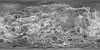
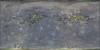
- These digital terrain mosaics (DTMs) and orthoimages were constructed to examine the topographic settings of landforms on Mercury called "hollows". They show the relationship between hollows and other topographic features. The locations were chosen based on the availability of high-resolution images and the occurrence of a variety of topographic settings.
Contact and Distribution
- Format
- Digital Elevation Model
- Access Scope
- Astrogeology, Astropedia, PDS
- Supplemental Information
- https://www.hou.usra.edu/meetings/lpsc2017/pdf/1656.pdf, https://messenger.jhuapl.edu/Explore/Science-Images-Database/gallery-image-655.html, http://messenger-act.actgate.com/msgr_public_released/react_quickmap.html
- Native Data Set Environment
- Astrogeology Theme
- Topography
- Mission Names
- MESSENGER
- Instrument Names
- MDIS
- Online Package Link
- https://astrogeology.usgs.gov/search/map/mercury_messenger_mdis_volatile_loss_dtm
- External File Size
- 25633784
- Online File Link
- http://astropedia.astrogeology.usgs.gov/download/Mercury/Messenger/MDIS/Mercury_Volatile_Loss/Mercury_Volatile_Loss.zip
- Access Instructions
- The ZIP file contains DEMs and associated orthorectified input images in the geotiff format, with detatched PDS4-style XML labels.
- Contact Address
- 2255 N. Gemini Drive
- Contact City
- Flagstaff
- Contact State
- AZ
- Contact Postal Code
- 86001
- Contact Email
- astroweb@usgs.gov
- Progress
- Complete
- Process Description
-
The DTMs were created using SOCET Set software to align the images, control them to Mercury Laser Altimeter (MLA) individual elevation points (when possible), and generate a topographic model via stereo matching. The resulting DTM was then hand-edited as needed to remove artifacts. The orthorectified images were projected onto the DTM, and the final DTM and orthorectified images were exported. Note that some artifacts may remain even after editing. Areas with dark shadows result in poor stereo correlation. The use of trade, product, or firm names is for identification purposes only and does not indicate an endorsement by the U.S. Government.
The DEMs and orthos provided here were derived from the following (informally named) locations on Mercury: Aksakov_Crater_Peak_Ring
Crater_Near_Dali_Crater
Crater_Near_Geddes_Crater (Not controlled with MLA)
Degas_crater
Kertesz_crater (includes mosaics)
Kertesz_crater_2
NW_of_Degas
Praxiteles_Peak_Ring (includes mosaics)
Raditladi_crater_peak_ring
Sander_crater
Sholem_Aleichem_crater_wall - Source Online Linkage
- {https://pds-imaging.jpl.nasa.gov/volumes/mess.html,https://pds-imaging.jpl.nasa.gov/portal/messenger_mission.html}
- Source PDS Archive
- MESSENGER
- PDS Status
- PDS 4 Compatible
Geospatial Information
- Target
- Mercury
- Object Type
- Grid Cell
- Quad Name
- Vertical Coordinate System Units
- Meters
- Map Projection Name
- Equirectangular
- Latitude Type
- Planetocentric
- Longitude Direction
- Positive East
- Longitude Domain
- 0 to 360