Mercury MESSENGER MDIS DTMs Fassett 2016
- Primary Authors
- Caleb I. Fassett
- Originators
- PDS
- Publisher
- USGS Astrogeology Science Center
- Publication Date
- 2016-12-01
- Abstract
- In this study, 96 digital terrain models (DTM/DEMs) and derived orthorecitifed images of Mercury were created using the NASA Ames Stereo Pipeline, using 1456 pairs of stereo images from the Mercury Dual Imaging System instrument on MErcury Surface, Space ENvironment, GEochemistry and Ranging (MESSENGER) mission. Although these DTMs cover only ~1% of the surface of Mercury, they enable three-dimensional characterization of landforms at horizontal resolutions of ~50â250 m/pixel and vertical accuracy of tens of meters. This is valuable in regions where the more precise measurements from the Mercury Laser Altimeter (MLA) are sparse. MLA measurements nonetheless provide an important geodetic framework for the derived stereo products. These DTMs, which are publicly released in conjunction with the Fassett 2016 journal article, reveal topography of features at relatively small scales, including craters, graben, hollows, pits, scarps, and wrinkle ridges. Measurements from these data indicate that: (1) hollows have a median depth of ~32 m, in basic agreement with earlier shadow measurement, (2) some of the deep pits (up to ~4 km deep) that are interpreted to form via volcanic processes on Mercury have surrounding rims or rises, but others do not, and (3) some pits have two or more distinct, low-lying interior minima that could represent multiple vents. References: Fassett, Caleb I., 2016, Ames stereo pipeline-derived digital terrain models of Mercury from MESSENGER stereo imaging, Planetary and Space Science Volume 134, 1 December 2016, Pages 19-28, doi: https://doi.org/10.1016/j.pss.2016.10.001 Beyer, Ross, Oleg, Alexandrov, McMichael, Scott, 2018, The Ames Stereo Pipeline: NASA's Open Source Software for Deriving and Processing Terrain Data. Earth and Space Science. 5. doi: http://dx.doi.org/10.1029/2018EA000409 Hawkins III, S.E., J.D. Boldt, E.H. Darlington, R. Espiritu, R. Gold, B. Gotwols, M.P. Grey, C.D. Hash, J.R. Hayes, S.E. Jaskulek, C.J. Kardian Jr., M.R. Keller, E.R. Malaret, S.L. Murchie, P.K. Murphy, K. Peacock, L.M. Prockter, A.R. Reiter, M.S. Robinson, E.D. Schaefer, R.G. Shelton, R.E. Sterner II, H.W. Taylor, T.R. Watters, B.D. Williams, 2007, The Mercury dual imaging system on the MESSENGER spacecraft, Space Sci. Rev., 131, pp. 247-338, doi: https://doi.org/10.1007/s11214-007-9266-3 Zuber, M.T. et al., 2012, Topography of the Northern Hemisphere of Mercury from MESSENGER laser altimetry Science, 336 (2012), pp. 217-220, doi: https://doi.org/10.1126/science.1218805
- Purpose
- Topographic information is useful for enhancing the interpretation of this image data and determining the relief of landforms. The focus of this study was on creating numerous local-to-regional-scale high resolution DTMs with resolution of ~250 m/pixel or better, covering as much of the Mercury surface as possible. These data provide local topography for parts of the Mercuryâs surface, including areas with hollows, craters, and pits.
Contact and Distribution
- Format
- Digital Elevation Model, Image, Raster Data, Remote-sensing Data, Topographic Map
- Access Constraints
- please cite authors
- Access Scope
- PDS, Photogrammetry
- Use Constraints
- public domain
- Edition
- 2
- Edition Name
- Version
- Supplemental Information
- https://doi.org/10.1016/j.pss.2016.10.001
- Native Data Set Environment
- ESRI Arcinfo, GDAL
- Astrogeology Theme
- Geographic Information System (GIS), Image Processing, Photogrammetry, Remote Sensing, Topography
- Mission Names
- MESSENGER
- Instrument Names
- MDIS
- Online Package Link
- https://astrogeology.usgs.gov/search/map/mercury_messenger_mdis_dtms_fassett_2016
- External File Size
- 273009758
- Online File Link
- http://astropedia.astrogeology.usgs.gov/download/Mercury/Topography/Fassett_MDIS_Stereo/Fassett_MESSENGER_MDIS_DEMs.zip
- Contact Address
- 2255 N. Gemini Drive
- Contact City
- Flagstaff
- Contact State
- AZ
- Contact Postal Code
- 86001
- Contact Email
- [email protected]
Data Status and Quality
- Time Period of Content (start)
- 2016-12-01
- Time Period of Content (stop)
- 2016-12-01
- Currentness Reference
- Publication date
- Progress
- Complete
- Update Frequency
- None planned
- Logical Consistency
- The post-processing procedures for the resulting point clouds varied depending on the availability of nearby stereo data and sufficient Mercury Laser Altimeter (MLA) point data to tie the point cloud to the MLA reference frame. Where stereo data overlapped sufficiently, as usually was the case, point clouds were mosaicked to each other by applying a rigid translation to match the point clouds using Iterative Closest Point registration with the Ames Stereo Pipeline's pc_align tool. For more see Fassett 2016.
- Completeness Report
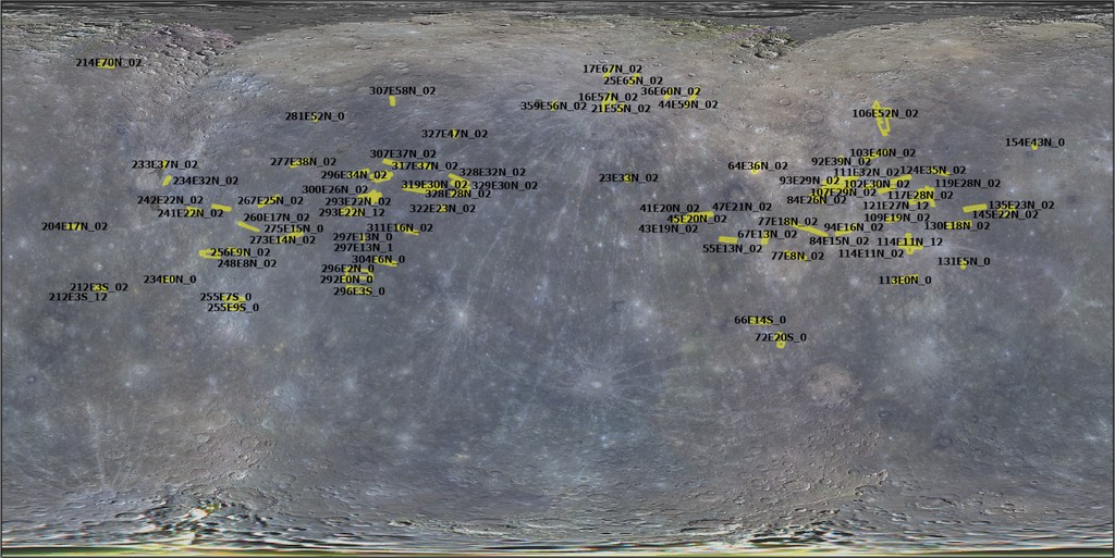
- DTMs are sporadically located and cover only ~1% of the surface of Mercury.
- Process Description
- The NASA Ames Stereo Pipeline (v.2.4.2) and the USGS Integrated Software for Imagers and Spectrometers (ISIS) (v.3.4.7, later upgraded through 3.4.10) packages were the primary tools used for photogrammetric processing. ISIS was used to ingest, calibrate MDIS data, and attach spacecraft attitude information, which were then fed to the Ames Stereo Pipeline on a stereo pairwise basis, as described in more detail in Section 2.5. After processing, the stereo DTMs and associated orthoimages are imported to ESRI's ArcMap for analysis.
- Source Title
- MESSENGER MDIS Archive
- Source Online Linkage
- https://pds-imaging.jpl.nasa.gov/portal/messenger_mission.html
- Source PDS Archive
- MESSENGER
- PDS Status
- Locally Archived
- Attribute Accuracy Report
- Best Effort
- Horizontal Positional Accuracy Report
- Best Effort
Geospatial Information
- Target
- Mercury
- Minimum Latitude
- -22.1
- Maximum Latitude
- 70.8
- Minimum Longitude
- -158.5
- Maximum Longitude
- 155
- Direct Spatial Reference Method
- Raster
- Object Type
- Grid Cell
- Bit Type (8, 16, 32)
- 32
- Quad Name
- Radius A
- 2440000
- Radius C
- 2440000
- Control Net
- MLA
- Bands
- 1
- Vertical Coordinate System Units
- Meters
- Map Projection Name
- Sinusoidal
- Latitude Type
- Planetocentric
- Longitude Direction
- Positive East
- Longitude Domain
- -180 to 180