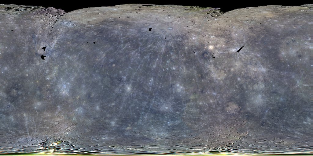
Mercury MESSENGER MDIS Global Color Mosaic 665m
- Primary Authors
- MESSENGER Team
- Originators
- Arizona State University
- Publisher
- USGS Astrogeology Science Center
- Abstract
- Product Information: This color mosaic is comprised of photometrically corrected I/F (radiance factor) for 3 narrow-band color filters of the Mercury Dual Imaging System (MDIS) Wide Angle Camera (WAC), placing the 1000-nm, 750-nm, and 430-nm filters in the red, green, and blue channels, respectively. The individual MDIS Wide Angle Camera (WAC) images were pointed to low emission angles on the surface, at times when the solar incidence angle was close to the lowest values possible at that latitude. The common areas of each set of 8 images (1 per filter) are mosaicked into 54 non-overlapping, 64 pixel/degree 8 band tiles or multi-spectral data records (MDRs). The resolution of this global mosaic is 250 meters per pixel (m). Mission and Instrument Information: The MErcury Surface, Space Environment, Geochemistry, and Ranging (MESSENGER) spacecraft launched on August 3rd, 2004, it entered orbit around Mercury on March 11, 2011 and ended its mission on April 30th, 2015 when it deliberately plunged into the surface or Mercury. MESSENGER was the first spacecraft to orbit Mercury and had the primary goal of studying the geology, magnetic field, and chemical composition of the planet. The science payload onboard MESSENGER included: Mercury Dual Imaging System (MDIS), Gamma-Ray Spectrometer (GRS), Neutron Spectrometer (NS), X-ray Spectrometer (XRS), Mercury Laser Altimeter (MLA), Mercury Atmospheric and Surface Composition (MACS), Energetic Particle and Plasma Spectrometer (EPPS), and Radio Science experiment (RS). The MDIS instrument suite consists of wide-angle (WAC) and narrow-angle imagers (NAC) situated on a pivot platform that enables the instruments to be pointed in specified directions. References: Becker, K. J., et al. (2009). Near Global Mosaic of Mercury: Eos, v. 90, 52, 29 December 2009, Fall Mtg. Suppl., abs. #P21A-1189. http://abstractsearch.agu.org/meetings/2009/FM/P21A-1189.html Hawkins, S. E., III, et al. (2009). In-flight performance of MESSENGER's Mercury Dual Imaging System. Proceedings of the SPIE, v. 7441, pp. 74410Z-74410Z-12. https://doi.org/10.1117/12.826370
- Purpose
- To create a multi-spectral mosaic for use during the primary mission.
Contact and Distribution
- Format
- Global Mosaic, Remote-sensing Data
- Access Constraints
- public domain
- Access Scope
- PDS
- Use Constraints
- Please cite authors
- Edition
- 3
- Supplemental Information
- http://messenger.jhuapl.edu/Explore/Images.html#global-mosaics
- Native Data Set Environment
- ISIS v3
- Astrogeology Theme
- Geomorphology, Regolith, Remote Sensing
- Mission Names
- MESSENGER
- Instrument Names
- MDIS
- Online Package Link
- https://astrogeology.usgs.gov/search/map/mercury_messenger_mdis_global_color_mosaic_665m
- External File Size
- 772 MB
- Online File Link
- https://planetarymaps.usgs.gov/mosaic/Mercury_MESSENGER_ClrMosaic_global_665m_v3.tif
- Contact Address
- 2255 N. Gemini Drive
- Contact City
- Flagstaff
- Contact State
- AZ
- Contact Postal Code
- 86001
- Contact Email
- astroweb@usgs.gov
- Process Description
- The bands are: (1000, 750, 430)nm. The reflectance contrast stretch values for the RGB are: *Red 0.0295111 to 0.190991 *Green 0.0193207 to 0.161358 *Blue 0.00517048 to 0.0979371
- Source Title
- Global Mosaics of Mercury
- Source Online Linkage
- {https://pds-imaging.jpl.nasa.gov/volumes/mess.html,https://pds-imaging.jpl.nasa.gov/portal/messenger_mission.html}
- PDS Status
- PDS 3 Archived
Geospatial Information
- Target
- Mercury
- Minimum Latitude
- -90
- Maximum Latitude
- 90
- Minimum Longitude
- -180
- Maximum Longitude
- 180
- Direct Spatial Reference Method
- Raster
- Object Type
- Grid Cell
- Raster Row Count (lines)
- 11527
- Raster Column Count (samples)
- 23054
- Bit Type (8, 16, 32)
- 8
- Quad Name
- Radius A
- 2440000
- Radius C
- 2440000
- Bands
- 3
- Pixel Resolution (meters/pixel)
- 665
- Scale (pixels/degree)
- 64.0389
- Map Projection Name
- Equirectangular
- Latitude Type
- Planetocentric
- Longitude Direction
- Positive East
- Longitude Domain
- -180 to 180


