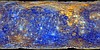

Mercury MESSENGER MDIS Basemap MD3 Color Global Mosaic 665m
- Primary Authors
- Applied Coherent Technology Corporation
- Originators
- NASA, Johns Hopkins Applied Physics Laboratory, Arizona State University, Carnegie Science
- Publisher
- USGS Astrogeology Science Center
- Publication Date
- 2016-05-13
- Abstract
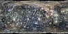
- This mosaic shows Mercury's colors as viewed by placing images from MESSENGER's 1000 nm, 750 nm, and 430 nm narrow-band filters in the red, green, and blue channel respectively. This is not what Mercury would look like to the human eye, but rather by using a wider range of wavelengths, color differences on Mercury's surface can be accentuated beyond those visible to a person. The projection defined is Simple Cylindrical centered on 0° latitude and 0° longitude. The 3-color Map Projected Multispectral RDR (MD3) data set consists of a mosaicked global color map of 3-color image sets, as reflectance corrected to i = 30º, e = 0º, and g = 30º sampled at a scale of 128 pixels per degree, compiled from images taken as a part of the regional 3-color map campaign. This is version 1 of the map, delivered at end of mission. Instead of the value from any single image being used at a particular pixel location in a given wavelength band, the value used is the average from all of the images at that location where criteria for image scale, photometric geometry, and detector temperature are met. This mosaic contains data acquired by the MErcury Surface, Space ENvironment, GEochemistry and Ranging (MESSENGER) Mercury Dual Imaging System (MDIS) instrument. References: MESSENGER Mercury Dual Imaging System (MDIS) Experiment Data Record (EDR) Software Interface Specification (SIS) document, The Johns Hopkins University, APL, V2T, Jun. 28, 2015. Hawkins, S.E., III, et al., The Mercury Dual Imaging System on the MESSENGER Spacecraft, Space Sci Rev 131: 247â338, DOI 10.1007/s11214-007-9266-3, 2007. Denevi, B.W. et al., Final calibration and multispectral map products from the Mercury Dual Imaging System Wide-Angle Camera on MESSENGER, Lunar Planet. Sci 47, abstract #1264.
Contact and Distribution
- Format
- Global Mosaic, Raster Data, Remote-sensing Data
- Access Constraints
- None
- Access Scope
- Use Constraints
- Please cite authors
- Edition
- 1
- Edition Name
- MESS-H-MDIS-5-RDR-MD3-V1.0
- Supplemental Information
- http://messenger.jhuapl.edu/Explore/Images.html#global-mosaics
- Native Data Set Environment
- ISIS v3
- Astrogeology Theme
- Geomorphology, Image Processing, Remote Sensing
- Mission Names
- MESSENGER
- Instrument Names
- MDIS, NAC, WAC
- Online Package Link
- https://astrogeology.usgs.gov/search/map/mercury_messenger_mdis_basemap_md3_color_global_mosaic_665m
- External File Size
- 760 MB
- Online File Link
- https://planetarymaps.usgs.gov/mosaic//Mercury_MESSENGER_MDIS_Basemap_MD3Color_Mosaic_Global_665m.tif
- Contact Address
- 2255 N. Gemini Drive
- Contact City
- Flagstaff
- Contact State
- AZ
- Contact Postal Code
- 86001
- Contact Email
- [email protected]
Data Status and Quality
- Time Period of Content (start)
- 2011-03-29
- Time Period of Content (stop)
- 2015-04-30
- Currentness Reference
- Ground condition
- Progress
- Complete
- Update Frequency
- As needed
- Process Description
- A stretch of approximately 0 to 0.2 is required to map Mercury reflectance values to an 8bit range of 1 to 255.
Lineage
- Process Date
- 2016-05-06
- Source Title
- COLOR MOSAIC
- Source Online Linkage
- http://messenger.jhuapl.edu/Explore/Images.html#global-mosaics
- Source PDS Archive
- MESSENGER
Geospatial Information
- Target
- Mercury
- Minimum Latitude
- -90
- Maximum Latitude
- 90
- Minimum Longitude
- -180
- Maximum Longitude
- 180
- Direct Spatial Reference Method
- Raster
- Object Type
- Grid Cell
- Raster Row Count (lines)
- 11520
- Raster Column Count (samples)
- 23040
- Bit Type (8, 16, 32)
- 8
- Quad Name
- Radius A
- 2439400
- Radius C
- 2439400
- Bands
- 3
- Pixel Resolution (meters/pixel)
- 665.24315271
- Scale (pixels/degree)
- 64
- Map Projection Name
- Simple Cylindrical
- Latitude Type
- Planetocentric
- Longitude Direction
- Positive East
- Longitude Domain
- -180 to 180