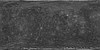
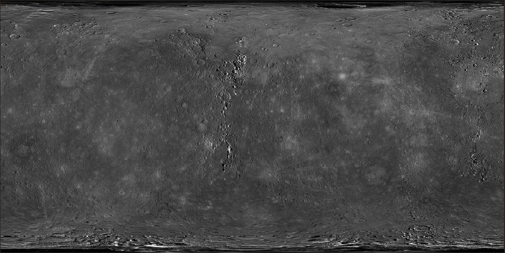
Mercury MESSENGER MDIS Global Mosaic 250m
- Primary Authors
- MESSENGER Team
- Originators
- Arizona State University, MESSENGER Team
- Publisher
- USGS Astrogeology Science Center
- Abstract
- Product Information: This May 2013 basemap is a combination of the following mosaics; (1) The 2013-05-10 version of the monochrome global mosaic, made from Applied Coherent Technology (ACT) Corporation tiles, (2) An average north polar mosaic from 90N to 82.5N, composed of images from many campaigns, made by C. Ernst, and (3) An average south polar mosaic from 90S to 85S, composed of images from the south polar monitoring campaign from the primary mission, made by N. Chabot. To fill minor areas of missing data, the 2013-05-10 version of the high-incidence global mosaic was underlain. This monochrome mosaic is composed of Mercury Dual Imaging System (MDIS) Narrow Angle Camera (NAC) images and Wide Angle Camers (WAC) images acquired in the filter centered at 750 nm. The resolution of this mosaic is 250 meters per pixel (m). Mission and Instrument Information: The MErcury Surface, Space Environment, Geochemistry, and Ranging (MESSENGER) spacecraft launched on August 3rd, 2004, it entered orbit around Mercury on March 11, 2011 and ended its mission on April 30th, 2015 when it deliberately plunged into the surface or Mercury. MESSENGER was the first spacecraft to orbit Mercury and had the primary goal of studying the geology, magnetic field, and chemical composition of the planet. The science payload onboard MESSENGER included: Mercury Dual Imaging System (MDIS), Gamma-Ray Spectrometer (GRS), Neutron Spectrometer (NS), X-ray Spectrometer (XRS), Mercury Laser Altimeter (MLA), Mercury Atmospheric and Surface Composition (MACS), Energetic Particle and Plasma Spectrometer (EPPS), and Radio Science experiment (RS). The MDIS instrument suite consists of wide-angle (WAC) and narrow-angle imagers (NAC) situated on a pivot platform that enables the instruments to be pointed in specified directions. References: Becker, K. J., et al. (2009). Near Global Mosaic of Mercury: Eos, v. 90, 52, 29 December 2009, Fall Mtg. Suppl., abs. #P21A-1189. http://abstractsearch.agu.org/meetings/2009/FM/P21A-1189.html Hawkins, S. E., III, et al. (2009). In-flight performance of MESSENGER's Mercury Dual Imaging System. Proceedings of the SPIE, v. 7441, pp. 74410Z-74410Z-12. https://doi.org/10.1117/12.826370
- Purpose
- To create the best grayscale image mosaic with 100% coverage at 250m/p.
Contact and Distribution
- Format
- Global Mosaic, Raster Data, Remote-sensing Data
- Access Constraints
- Public domain
- Access Scope
- PDS
- Use Constraints
- Please cite authors
- Edition
- May 2013
- Supplemental Information
- http://messenger-act.actgate.com/msgr_public_released/react_quickmap.html, http://messenger.jhuapl.edu/Explore/Images.html#global-mosaics
- Native Data Set Environment
- ISIS v3
- Astrogeology Theme
- Geomorphology, Image Processing, Remote Sensing
- Mission Names
- MESSENGER
- Instrument Names
- MDIS
- Online Package Link
- https://astrogeology.usgs.gov/search/map/mercury_messenger_mdis_global_mosaic_250m
- External File Size
- 2 GB
- Online File Link
- https://planetarymaps.usgs.gov/mosaic//Mercury_MESSENGER_mosaic_global_250m_2013.tif
- Contact Address
- 2255 N. Gemini Drive
- Contact City
- Flagstaff
- Contact State
- AZ
- Contact Postal Code
- 86001
- Contact Email
- [email protected]
- Currentness Reference
- Publication date
- Completeness Report
- MESSENGER obtained the final image needed to view 100% of Mercury's surface under daylight conditions.
- Process Description
- To fill the area near the north pole, the PDS product was trimmed northward of 83°N and an average mosaic that extended from 82.5°N to 90°N was used, averaging the 0.5° latitude overlap between the PDS mosaic and the average north polar mosaic. To fill the area near the south pole, the PDS product was trimmed southward of 85.5°S and an average mosaic that extended from 85°S to 90°S was used, again averaging the 0.5° latitude overlap. Any remaining gaps in the global mosaic were filled by using images obtained in support of the high-incidence imaging campaign. The global maps are centered at 0° longitude in Simple Cylindrical projection. The polar mosaics are in Polar Stereographic projections that extend to 65° north or south latitude, with 180° longitude at the top of the north polar mosaic and 0° longitude at the top of the south polar mosaic.
Lineage
- Process Date
- 2013-05-01
- Source Title
- Global Mosaics of Mercury
- Source Online Linkage
- {https://pds-imaging.jpl.nasa.gov/volumes/mess.html,https://pds-imaging.jpl.nasa.gov/portal/messenger_mission.html}
- PDS Status
- PDS 3 Archived
Geospatial Information
- Target
- Mercury
- Minimum Latitude
- -90
- Maximum Latitude
- 90
- Minimum Longitude
- -180
- Maximum Longitude
- 180
- Direct Spatial Reference Method
- Raster
- Object Type
- Grid Cell
- Raster Row Count (lines)
- 30662
- Raster Column Count (samples)
- 61324
- Bit Type (8, 16, 32)
- 8
- Quad Name
- Radius A
- 2440000
- Radius C
- 2440000
- Bands
- 1
- Pixel Resolution (meters/pixel)
- 250
- Scale (pixels/degree)
- 170.34444444444
- Map Projection Name
- Equirectangular
- Latitude Type
- Planetocentric
- Longitude Direction
- Positive East
- Longitude Domain
- -180 to 180