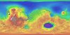

Mars MGS MOLA Global Color Shaded Relief 463m
- Primary Authors
- Astrogeology
- Originators
- USGS Astrogeology Science Center, Goddard Space Flight Center, NASA
- Publisher
- USGS Astrogeology Science Center
- Abstract
- Product Information: This map is based on data from the Mars Orbiter Laser Altimeter (MOLA) (Smith, et al., 2001), an instrument on NASA's Mars Global Surveyor (MGS) spacecraft (Albee, et al., 2001). The image used for the base of this map represents more than 600 million measurements gathered between 1999 and 2001, adjusted for consistency (Neumann, et al., 2001; Neumann, et al., 2003) and converted to planetary radii. These have been converted to elevations above the areoid as determined from a Martian gravity field solution GMM-2B (Lemoine, et al., 2001), truncated to degree and order 50, and oriented according to current standards (see below). The average accuracy of each point is originally ~100 meters in horizontal position and ~1 meter in radius (Neumann, et al., 2001; Neumann, et al., 2003). However, the total elevation uncertainty is at least ±3 m due to the global error in the areoid (±1.8 meters; Lemoine, et al., 2001) and regional uncertainties in its shape (Neumann, 2002). Pixel resolution of this map is 463 meters per pixel (m). Mission and Instrument Information: MGS was the first successful U.S. mission launched to Mars since the Viking mission in 1976 (Albee et al., 2001). MGS launched on November 7, 1996 atop a three-stage Delta II launch vehicle from launch pad 17A at Cape Canaveral Air Station, FL. The thirdstage Star 48B solid rocket later propelled the spacecraft out of Earth orbit and on its way to Mars. After a 20-year absence at the planet, MGS ushered in a new era of Mars exploration with its five science investigations (NASA JPL, 2010) MGS arrived at Mars in September 1997 and has contributed a multitude of findings, including signs of past, persistent water such as an ancient delta and currently active water features in the gullies of canyon walls. After nearly a decade of discovery, MGS went silent in November 2006 (NASA JPL, 2010). The MOLA created the most accurate global topographic map of any planet in the solar system, giving scientists elevation maps precise to within about 30 centimeters (1 foot) in the vertical dimension. Data from the laser altimeter identified pathways for the flow of past water and the locations, sizes, and volumes of watersheds. The instrument detected the heights of clouds and identified dynamic features in the atmosphere, such as gravity waves (NASA JPL, 2010). The MOLA showed seasonal changes in the height of the Martian surface (such as snow depth) that represented the first direct global measurement of the amount and distribution of condensed carbon dioxide. In June 2001, part of the laser reached the end of its life, but a sensor continued to detect changes in surface brightness in the near infrared part of the spectrum. These data provided evidence of cloud coverage and atmospheric variations (NASA JPL, 2010). References: Albee, A. L., Arvidson, R. E., Palluconi, F., & Thorpe, T. (2001). Overview of the Mars Global Surveyor mission. Journal of Geophysical Research, 106(E10), 23291-23316. https://doi.org/10.1029/2000JE001306 de Vaucouleurs, G., Davies, M. E., & Sturms Jr., F. M. (1973). Mariner 9 areographic coordinate system. Journal of Geophysical Research, 78, 4395-4404. https://doi.org/10.1029/JB078i020p04395 Duxbury, T. C., Kirk, R. L., Archinal, B. A., & Neumann, G. A. (2002). Mars Geodesy/Cartography Working Group recommendations on Mars cartographic constants and coordinate systems. Paper presented at Joint International Symposium on Geospatial Theory, Processing and Applications: ISPRS Commission IV Proceedings, Working Group 9âExtraterrestrial Mapping, Proceedings, International Society for Photogrammetry and Remote Sensing, Ottawa, Canada. http://www.isprs.org/commission4/proceedings/paper.html Greeley, R., & Batson, R. M. (1990). Planetary mapping (274-275), Cambridge, UK: Cambridge University Press. ISBN 0-521-30774-0 Lemoine, F. G., Smith, D. E., Rowlands, D. D., Zuber, M. T., Neumann, G. A., Chinn, D. S., & Pavlis, D. E. (2001). An Improved Solution of the Gravity Field of Mars (GMM-2B) from Mars Global Surveyor. Journal of Geophysical Research-Planets, 106(E10), 23359-23376. https://doi.org/10.1029/2000JE001426 National Aeronautics and Space Administration (NASA) Jet Propulsion Laboratory (JPL) (2010). Mars Global Surveyor. https://mars.nasa.gov/mgs/overview/ Neumann, G. A., Rowlands, D. D., Lemoine, F. G., Smith, D. E., & Zuber, M. T. (2001). Crossover analysis of Mars Orbiter Laser Altimeter data. Journal of Geophysical Research, 106(E10), 23753-23768. https://doi.org/10.1029/2000JE001381 Neumann, G. A. (2002). Written communication. Neumann, G. A., Smith, D. E., & Zuber, M. T. (2003). Two Mars years of clouds detected by the Mars Orbiter Laser Altimeter. Journal of Geophysical Research, 108(E4), 5023. https://doi.org/10.1029/2002JE001849 Seidelmann, P. K., Abalakin, V. K. Bursa, M., Davies, M. E., de Bergh, C., Lieske, J. H., Oberst, J., et al. (2002). Report of the IAU/IAG Working Group on Cartographic Coordinates and Rotational Elements of the Planets and Satellitesâ2000. Celestial Mechanics and Dynamical Astronomy, 82, 83-110. https://doi.org/10.1007/s10569-010-9320-4 Smith, D. E., Sjogren, W. L., Tyler, G. L., Balmino, G., Lemoine, F. G., & Konopliv, A. S. (1999). The gravity field of MarsâResults from Mars Global Surveyor. Science, 286, 94-96. https://doi.org/10.1126/science.286.5437.94 Smith, D. E., Zuber, M. T., Frey, H. V., Garvin, J. B., Head, J. W., Muhleman, D. O., Pettengill, G. H., et al. (2001). Mars Orbiter Laser Altimeter Experiment summary after the first year of global mapping of Mars. Journal of Geophysical Research, 106(E10), 23689â23722. https://doi.org/10.1029/2000JE001364 Wessel, P., & Smith, W. H. F. (1998). New, improved version of Generic Mapping Tools released. Eos, Transactions of the American Geophysical Union, 79(47), 579. https://doi.org/10.1029/98EO00426
- Purpose
- The Mars Orbiter Laser Altimeter (MOLA) produced a high-resolution global topographic model and geodetic framework that enables precise targeting, safe landing, and surface mobility to carry out exploratory activities.
Contact and Distribution
- Format
- Remote-sensing Data, Shaded-Relief Map, Topographic Map
- Access Constraints
- Public domain
- Access Scope
- PDS
- Use Constraints
- None
- Edition
- 1
- Supplemental Information
- http://pds-geosciences.wustl.edu/missions/mgs/mola.html, http://mola.gsfc.nasa.gov/
- Native Data Set Environment
- ISIS v3
- Astrogeology Theme
- Geographic Information System (GIS), Remote Sensing, Topography
- Mission Names
- Mars Global Surveyor
- Instrument Names
- MOLA
- Online Package Link
- https://astrogeology.usgs.gov/search/map/mars_mgs_mola_global_color_shaded_relief_463m
- External File Size
- 1 GB
- Online File Link
- https://planetarymaps.usgs.gov/mosaic/Mars_MGS_MOLA_ClrShade_merge_global_463m.tif
- Contact Address
- 2255 N. Gemini Drive
- Contact City
- Flagstaff
- Contact State
- AZ
- Contact Postal Code
- 86001
- Contact Email
- [email protected]
- Currentness Reference
- Publication date
- Progress
- Complete
- Update Frequency
- None planned
- Logical Consistency
- The average accuracy of each point is originally ~100 meters in horizontal position and ~1 meter in radius (Neumann and others, 2001). However, the total elevation uncertainty is at least ±3 m due to the global error in the areoid (±1.8 meters according to Lemoine and others [2001]) and regional uncertainties in its shape (G.A. Neumann, written commun., 2002). The MOLA data were initially referenced to an internally consistent inertial coordinate system, derived from tracking of the MGS spacecraft. These values include the orientation of the north pole of Mars (including the effects of precession), the rotation rate of Mars, and a value for W0 of 176.630°, where W0 is the angle along the equator to the east, between the 0° meridian and the equator's intersection with the celestial equator at the standard epoch J2000.0 (Seidelmann and others, 2002). This value of W0 was chosen (Duxbury and others, 2002) in order to place the 0° meridian through the center of the small (~500 m) crater Airy-0, within the crater Airy (Seidelmann and others, 2002; de Vaucouleurs and others, 1973). Longitude increases to the east and latitude is planetocentric as allowed by IAU/IAG standards (Seidelmann and others, 2002) and in accordance with current NASA and USGS standards (Duxbury and others, 2002).
- Completeness Report
- Data are very sparse near the two poles (above 87° north and below 87° south latitude) because these areas were sampled by only a few off-nadir altimetry tracks. Gaps between tracks of 1-2 km are common, and some gaps of up to 12 km occur near the equator. DEM points located in these gaps in MOLA data were filled by interpolation.
- Process Description
- The measurements were converted into a digital elevation model (DEM; G.A. Neumann, written commun., 2002; Neumann and others, 2001; Smith and others 2001) using Generic Mapping Tools software (Wessel and Smith, 1998), with a resolution of 128 pixels per degree. In projection, the pixels are 463 meters in size at the equator. To create the topographic base image, the original DEM was produced by the MOLA team in Simple Cylindrical projection with a resolution of 128 pixels per degree. A shaded relief was generated from the DEM with a sun angle of 45° from horizontal and a sun azimuth of 315°, as measured clockwise from north, and a vertical exaggeration of 100%. The DEM values were then mapped to a smooth global color look-up table. Note that the chosen color scheme simply represents elevation changes and is not intended to imply anything about surface characteristics (for example, past or current presence of water or ice).
Lineage
- Process Date
- 2003-03-31
- Source Title
- Mars Global Surveyor: MOLA MEGDRs
- Source Online Linkage
- {http://geo.pds.nasa.gov/missions/mgs/megdr.html,http://pds-geosciences.wustl.edu/missions/mgs/index.htm}
- PDS Status
- PDS 3 Like
- Attribute Accuracy Report
- Accurate to Control Net
- Horizontal Positional Accuracy Report
- Accurate to Control Net
- Vertical Positional Accuracy Report
- Accurate to Control Net
Geospatial Information
- Target
- Mars
- System
- Mars
- Minimum Latitude
- -90
- Maximum Latitude
- 90
- Minimum Longitude
- -180
- Maximum Longitude
- 180
- Direct Spatial Reference Method
- Raster
- Object Type
- Grid Cell
- Raster Row Count (lines)
- 23040
- Raster Column Count (samples)
- 46080
- Bit Type (8, 16, 32)
- 8
- Quad Name
- Radius A
- 3396190
- Radius C
- 3376200
- Bands
- 3
- Pixel Resolution (meters/pixel)
- 463.0836
- Scale (pixels/degree)
- 128
- Map Projection Name
- Simple Cylindrical
- Latitude Type
- Planetocentric
- Longitude Direction
- Positive East
- Longitude Domain
- -180 to 180