Dawn Space Probe
Prior to NASA’s Dawn mission, the dwarf planet Ceres was widely believed to contain a substantial ice-rich layer below its rocky surface. The existence of such a layer has significant implications for Ceres’ formation, evolution, and astrobiological potential. Ceres’ surface temperature virtually ensures that large impact craters should be erased by viscous flow (a process called "viscous relaxation") on short geologic timescales if Ceres is, in fact, ice-rich. Measurements using digital terrain models derived from Dawn framing camera images, show that most of Ceres’ largest craters are several kilometers deep, and are therefore inconsistent with the existence of an ice-rich subsurface. Preventing viscous relaxation requires that Ceres’ subsurface has a viscosity at least one thousand times greater than that of pure water ice. Ceres’ shallow subsurface is therefore no more than 30%-40% ice by volume, with a mixture of rock, salts, and/or clathrates accounting for the other 60%-70%. However, several anomalously shallow craters suggest limited viscous relaxation has occurred, possibly indicating spatial variations in the ice content of the subsurface.

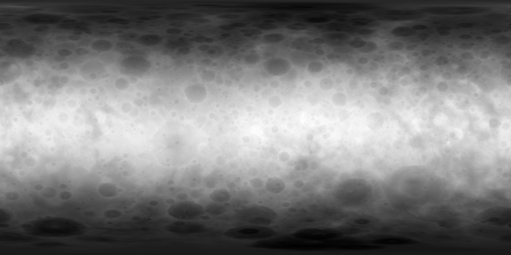
Ceres Dawn FC2 HAMO Global DTM 137m
Digital Elevation Model | Grey Scale | Raster Data | Topographic Map 2016-08-19Product Information: This digital terrain model (DTM) of Ceres based on the Dawn High Altitude Mapping Orbit (HAMO) Framing Camera 2 (FC2) images and derived by using the stereo photogrammetry (SPG) method.
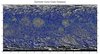
Ceres Dawn FC Global Mosaic 140m
Global Mosaic | Remote-sensing Data 2016-02-04Product Information: The Dawn Framing Camera (FC) captured images of Ceres with a resolution of about 140 meters per pixel (m) in 2015 (Preusker et al., 2016). German Aerospace Center (DLR) map-projected
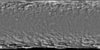
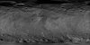
Ceres Dawn FC Global Mosaic 400m
Global Mosaic | Remote-sensing Data 2015-10-20Product Information: The Dawn framing camera (FC) acquired images of Ceres with a resolution of about 400 meters per pixel (m) during approach in 2015 (Preusker et al., 2016). German Aerospace Center
Ceres Dawn FC HAMO Hillshade 60ppd Oct. 2016
Digital Elevation Model | Grey Scale | Remote-sensing Data | Shaded-Relief Map 2016-10-17This is a grayscale hillshade of the original Ceres digital terrain model (DTM). This DTM was created from the Dawn High Altitude Mapping orbit (HAMO) Framing Camera 2 (FC2) images and derived
Ceres Dawn Zeilnhofer Crater Database 2020
Database | Tabular Data | Vector Data 2021-10-14Product Information: Update: Oct. 14, 2021 to version 2 which includes polygonal impact craters (Excel table) as described in Zeilnhofer, 2021. The Cerean crater database contains 44,594 craters ⥠1.0 km in
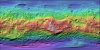
Vesta Dawn FC HAMO Global Color Shaded Relief 93m
Color | Global Mosaic | Raster Data | Shaded-Relief Map 2013-12-10Product Information: This is a colorized shaded-relief of the original stereo-derived High Altitude Mapping Orbit (HAMO) digital terrain model (DTM). DAWN orbited Vesta during HAMO in 21 cycles between December 2011 and

Vesta Dawn FC HAMO Global DTM 93m
Digital Elevation Model | Global Mosaic | Raster Data 2013-12-12Product Information: DAWN orbited Vesta during HAMO in 21 cycles between December 2011 and end of April 2012. Dawn orbited Vesta during HAMO in 6 cycles between end of September end early
Vesta Dawn FC HAMO Global Mosaic 60m
Global Mosaic | Raster Data | Remote-sensing Data 2013-12-10Product Information: DAWN orbited Vesta during HAMO in 21 cycles between December 2011 and end of April 2012 and in 6 cycles between end of September end early November 2011. The FC


