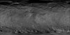
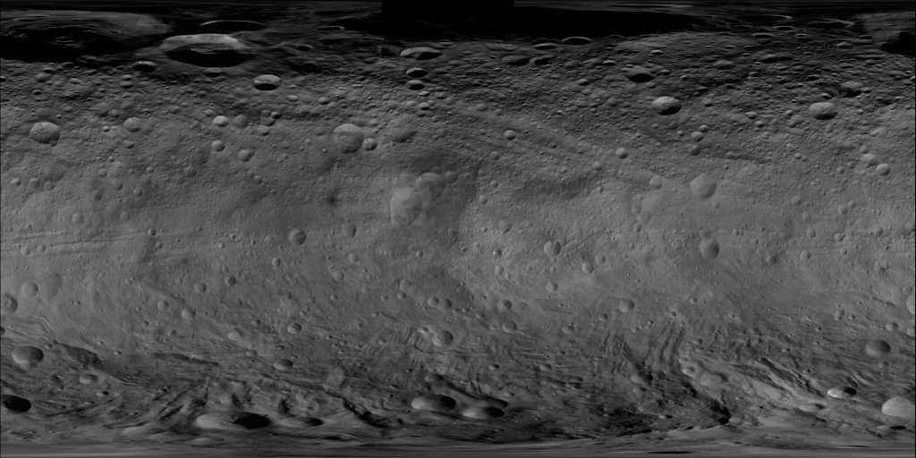
Vesta Dawn FC HAMO Global Mosaic 60m
- Primary Authors
- NASA/JPL-Caltech/UCLA/MPS/DLR/IDA
- Originators
- Dawn Team
- Publisher
- USGS Astrogeology Science Center
- Publication Date
- 2013-12-10
- Abstract
- Product Information: DAWN orbited Vesta during HAMO in 21 cycles between December 2011 and end of April 2012 and in 6 cycles between end of September end early November 2011. The FC took about 2,500 clear filter images with a resolution of about 60 meters per pixel (m) during these cycles. The images were taken with different viewing angles and different illumination conditions. Pixel resolution is 60 meters per pixel (m). We selected images from one cycle (cycle 3) for the mosaicking process to have similar viewing and illumination conditions. Cycle 3 with 518 images was selected since it was the first cycle with almost complete global coverage. Very minor gaps in the coverage were filled with a few images from cycle 2 (Roatsch et al., 2012). Note: This preliminary file has been shifted 150 degrees eastward (such that Claudia crater is located at 146E) to match the IAU-approved Claudia Double Prime system (from the Dawn-Claudia system as released by DLR in November 2013). Mission and Instrument Information: The Dawn spacecraft launched on September 25, 2007 onboard a Delta II-Heavy Rocket. The instrument payload consisted of two identical framing cameras (FC1 & FC2), a visible and infrared mapping spectrometer (VIR, and a gamma ray and neutron detector (GRaND). DAWN is a National Aeronautics and Space Administration (NASA) Discovery Program mission managed by the Jet Propulsion Laboratory (JPL) with the principal investigator and science operations center located at the University of California, Los Angeles. The framing cameras were built by the Max Planck Institute for Solar System Research with significant contributions by the German Aerospace Center, Institute of Planetary Research (DLR) and in coordination with the Institute of Computer and Communication Network Engineering (Polansky et al., 2016). Dawn spacecraft orbited Vesta in a series of science orbits designed to gradually increase the resolution and quality of science measurements as the mission at each target (Vesta & Ceres) progressed. The four science orbits are: rotation characterizations (RC1 and RC2) at 14,000 km, survey at 4,900 km (RC3), high altitude mapping orbit (HAMO) 1,950 km, and low altitude mapping orbit (LAMO) 850 km. HAMO provided the opportunity to collect data for the global topography model by collecting six complete clear-image maps: two at nadir and four at off-nadir attitudes (Polansky et al., 2016). References: Polanskey, C., Joy, S., & Raymond, C. (2016). Dawn Ceres Mission: Science Operations Performance. Paper presented at the SpaceOps Conference, Daejeon, Korea. https://arc.aiaa.org/doi/abs/10.2514/6.2016-2442 Preusker, F., Scholten, F., Matz, K.-D., Roatsch, T., Jaumann, R., Raymond, C. A., & Russell, C. T. (2014). Global Shape of Vesta from Dawn FC stereo images. Paper presented at the 45th Lunar Planetary Science Conference, Lunar and Planetary Institute, Houston, TX. http://www.hou.usra.edu/meetings/vesta2014/pdf/2027.pdf Roatsch, T., Kersten, E., Matz, K.-D., Preusker, F., Scholten, F., Jaumann, R., Raymond, C. A., & Russell, C. T. (2012). High resolution Vesta High Altitude Mapping Orbit (HAMO) Atlas derived from Dawn framing camera images. Planetary and Space Science, 73(1), 283-286. https://doi.org/10.1016/j.pss.2012.08.021 Russell, C. T., & Raymond, C. A. (2011). The Dawn Mission to Vesta and Ceres. Space Science Reviews, 163(1-4), 3-23. https://doi.org/10.1007/s11214-011-9836-2
- Purpose
- The NASA Dawn spacecraft entered orbit of the inner main belt asteroid 4 Vesta on July 16, 2011, and spent about one year in orbit to characterize the geology, elemental and mineralogical composition, topography, shape, and internal structure of Vesta. One of the major goals of the mission was a global mapping of Vesta. The DAWN mission was mapping Vesta from three different orbit heights during Survey orbit (3100 km altitude), HAMO (High Altitude Mapping Orbit, 700 km altitude), and LAMO (Low Altitude Mapping Orbit, 210 km altitude).
Contact and Distribution
- Format
- Global Mosaic, Raster Data, Remote-sensing Data
- Access Constraints
- None
- Access Scope
- PDS
- Use Constraints
- Please cite authors
- Edition
- 20131210
- Supplemental Information
- http://www.sciencedirect.com/science/article/pii/S0032063312002589, http://dawndata.igpp.ucla.edu/tw.jsp?section=data/FC/Maps/HAMO_mosaic_DLR, http://dawndata.igpp.ucla.edu/download.jsp?file=documents/VESTA_COORDINATES/VESTA_COORDINATES_121214.PDF, http://dawndata.igpp.ucla.edu/
- Native Data Set Environment
- ISIS v3
- Astrogeology Theme
- Asteroids, Image Processing, Remote Sensing
- Mission Names
- Dawn
- Online Package Link
- https://astrogeology.usgs.gov/search/map/vesta_dawn_fc_hamo_global_mosaic_60m
- External File Size
- 341 MB
- Online File Link
- https://planetarymaps.usgs.gov/mosaic/Vesta_Dawn_FC_HAMO_Mosaic_Global_74ppd.tif
- Contact Address
- 2255 N. Gemini Drive
- Contact City
- Flagstaff
- Contact State
- AZ
- Contact Postal Code
- 86001
- Contact Email
- [email protected]
Data Status and Quality
- Time Period of Content (start)
- 2011-12-01
- Time Period of Content (stop)
- 2012-04-30
- Currentness Reference
- Ground condition
- Progress
- In Work
- Update Frequency
- As needed
- Logical Consistency
- The Framing Camera is a multispectral imager that also serves as an optical navigation camera. The detector is a 1024x1024 pixel Atmel/Thomson TH7888A CCD with 14 micron pixels. It has eight filters numbered F1 through F8, including a broadband (clear) filter and narrow band filters ranging from 438 nm to 965 nm. The Framing camera instrument includes two redundant cameras of identical design, referred to as FC1 and FC2. For full information about the FC instrument, see Schroeder and Gutierrez-Marques (2011). Reference: Schroeder, S.E., and P. Gutierrez-Marques, Calibration Pipeline, MPS Report DA-FC-MPAE-RP-272, Issue 2, Rev. a, 20 July 2011.
- Completeness Report
- The framing camera took about 2, 500 clear filter images with a resolution of about 70 meter per pixel during the various cycles.
- Process Description
- The first step of the processing chain is to ortho rectify the images to the proper scale and map projection type. This process requires detailed high-resolution information of the local topography of Vesta. The global topgraphy was calculated during the stereo processing of the HAMO images and was used here. The shape model was used for the calculation of the ray intersection points while the map projection itself was done onto a sphere with a mean radius of 255 km. The next step was the mosaicing of all images to one global mosaic of Vesta, the so called basemap. Note: This preliminary file has been shifted 150 degrees eastward (such that Claudia crater is located at 146E) to match the IAU-approved Claudia Double Prime system (from the Dawn-Claudia system as released by DLR in November 2013). At the original edge when wrapped a nodata line was pushed into the mosaic. This was covered using a couple neighboring pixels for artistic purposes only.
- Source Title
- Dawn FC HAMO Global Mosaic
- Source Online Linkage
- {https://sbn.psi.edu/pds/resource/dawn/dwnvfcmosaics.html,https://sbn.psi.edu/pds/archive/maps.html}
- PDS Status
- PDS 3 Archived
- Attribute Accuracy Report
- Best Effort
- Horizontal Positional Accuracy Report
- Unknown
- Vertical Positional Accuracy Report
- Unknown
Geospatial Information
- Target
- Vesta
- System
- Small Bodies
- Minimum Latitude
- -90
- Maximum Latitude
- 90
- Minimum Longitude
- -180
- Maximum Longitude
- 180
- Direct Spatial Reference Method
- Raster
- Object Type
- Grid Cell
- Raster Row Count (lines)
- 13352
- Raster Column Count (samples)
- 26704
- Bit Type (8, 16, 32)
- 8
- Quad Name
- Radius A
- 255000
- Radius C
- 255000
- Bands
- 1
- Pixel Resolution (meters/pixel)
- 59.99896095
- Scale (pixels/degree)
- 74.1778
- Map Projection Name
- Simple Cylindrical
- Latitude Type
- Planetocentric
- Longitude Direction
- Positive East
- Longitude Domain
- -180 to 180