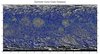
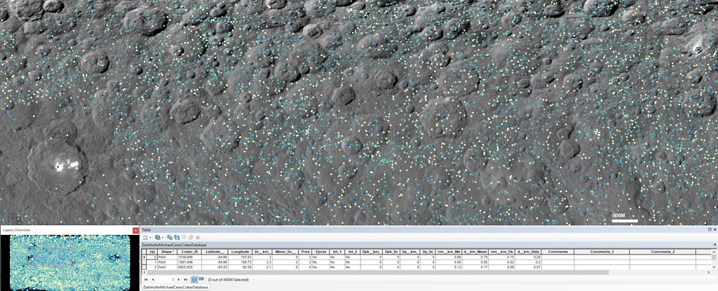
Ceres Dawn Zeilnhofer Crater Database 2020
- Primary Authors
- Michael F. Zeilnhofer
- Originators
- Michael F. Zeilnhofer, Nadine G. Barlow
- Publisher
- USGS Astrogeology Science Center
- Publication Date
- 2021-10-14
- Abstract
- Product Information: Update: Oct. 14, 2021 to version 2 which includes polygonal impact craters (Excel table) as described in Zeilnhofer, 2021. The Cerean crater database contains 44,594 craters ⥠1.0 km in diameter in the latitude range of 84.66ºS-89.62ºN over all longitudes [Zeilnhofer, 2020]. This crater database contains eighteen columns of information on each crater. For further detail on the column information please see the dissertation entitled: âA Global Analysis of Impact Craters on Ceresâ. It is also important to note that the database does not contain information on the south pole of Ceres due to this region being permanently shadowed in the Dawn images [Platz et al., 2016]. Craters were identified using the Low Altitude Mapping Orbit (LAMO) global mosaic of Ceres found within the Java Mission-planning and Analysis for Remote Sensing (JMARS) software [Gorelick et al., 2003]. The center latitude (°N) and longitude (°E) along with the measured crater diameter (km) were determined using the 3-point crater counting subroutine found within JMARS [Christensen et al., 2009; Wren et al., 2017]. The crater depth (km) and crater rim height (km) are also included in this database and were obtained from the topography data which were created from the digital elevation models (DEM) for the entire surface of Ceres. Mission and Instrument Information: The Dawn spacecraft is a National Aeronautics and Space Administration (NASA) Discovery Program mission managed by the Jet Propulsion Laboratory (JPL) team located at the University of California, Los Angeles and was launched from Cape Canaveral, Florida on September 25, 2007 [Polanskey et al., 2016]. The Dawn spacecraft is equipped with two identical Framing Cameras (FC2, the primary camera and FC1, the backup camera) [Sierks et al., 2011], a Visible and Infrared Mapping Spectrometer (VIR) [De Sanctis et al., 2011] and a Gamma Ray and Neutron Detector (GRaND) [Prettyman et al., 2011]. The Dawn spacecraft went into orbit around Ceres on March 6, 2015 and was retired on November 1, 2018. There were several mission phases including the third rotation characterization (RC3), survey, High Altitude Mapping Orbit (HAMO), Low Altitude Mapping Orbit (LAMO) and the extended mission orbits [Polanskey et al., 2016; Dongsuk et al., 2019]. The data for this database were acquired from the NASA Dawn spacecraftâs Framing Camera during the HAMO (resolution of 140 m/pixel) [Roatsch et al., 2016] and the LAMO phases (resolution of 35 m/pixel) [Roatsch et al., 2017]. The HAMO phase included six cycles at an altitude of â¼1475 km [Russell and Raymond, 2011]. The HAMO global mosaic was created using the 2490 clear filter images acquired during these cycles [Roatsch et al., 2016]. The LAMO phase included eleven cycles with images acquired at altitudes between 365 and 410 km [Russell and Raymond, 2011]. The LAMO global mosaic was created using the 31,300 clear filter images acquired during this phase [Roatsch et al., 2017]. The digital elevation models (DEM) were produced from the stereographic Framing Camera images resulting in two topography models (the mean spheroid model and the oblate spheroid model) which are included within JMARS. The mean spheroid model uses the DEM radii of a sphere with a radius of 469,430 m [Raymond et al., 2011; Roatsch et al., 2016] and the oblate spheroid model subtracts an oblate spheroid from the DEM radii of a sphere with a radius of 469,430 m to help conserve local topography differences across the body [Raymond et al., 2011; Roatsch et al., 2016]. References: Christensen, P. R., Engle, E., Anwar, S., Dickenshied, S., Noss, D., Gorelick, N., and Weiss-Malik, M. (2009). JMARS - A Planetary GIS. AGU Fall Meeting Abstracts, (pp. IN22Aâ06). De Sanctis, M.C., Coradini, A., Ammannito, E., Filacchione, G., Capria, M.T., Fonte, S., Magni, G., Barbis, A., Bini, A., Dami, M., Ficai-Veltroni, I., Preti, G., and VIR Team, (2011), The VIR Spectrometer, Space Science Review, 163, 329-369, doi: 10.1007/s11214-010-9668-5. Dongsuk, H., Brian, K., Brian, R., Daniel, G., Nickolaos, M., Gregory, W., Nicholas, B., and Reza, K. (2019). Dawnâs Final Mission at Ceres: Navigation and Mission Design Experience. 18th Australian Aerospace Congress, 24-28 February 2019, Melbourne. 1-15. Gorelick, N. S., Weiss-Malik, M., Steinberg, B., and Anwar, S. (2003). JMARS: A Multimission Data Fusion Application. 34th Annual Lunar and Planetary Science Conference, 34. Platz, T., Nathues, A., Schaefer, M., Schenk, P., Kneissl, T., Hoffmann, M., Schmedemann, N., Hiesinger, H., Sykes, M. V., Raymond, C. A., and Russell, C. T. (2016). Impact Cratering on Ceres: The Simple-to-Complex Transition. In Lunar and Planetary Science Conference (p. 2308). volume 47 of Lunar and Planetary Science Conference. Polanskey, C., Joy, S., and Raymond, C. (2016). Dawn Ceres Mission: Science Operations Performance. Paper presented at the SpaceOps Conference, Daejeon, Korea. https://arc.aiaa.org/doi/abs/10.2514/6.2016-2442 Prettyman, T. H., Feldman, W. C., McSwen, H. Y., Dingler, R. D., Enemark, D. C., Patrick, D. E., Storms, S. A., Hendricks, J. S., Morgenthaler, J. P., Pitman, K. M., and Reedy, R. C. (2011). Dawnâs Gamma Ray and Neutron Detector, Space Science Reviews, 163 371-459. doi: 10.1007/s11214-011-9862-0. Roatsch, T., Kersten, E., Matz, K.-D., Preusker, F., Scholten, F., Jaumann, R., Raymond, C. A., and Russell, C. T. (2016). High-resolution Ceres High Altitude Mapping Orbit atlas derived from Dawn Framing Camera images. Planetary Space Science, 129, 103â107. doi:10.1016/j.pss.2016.05.011. Roatsch, T., Kersten, E., Matz, K.-D., Preusker, F., Scholten, F., Jaumann, R., Raymond, C. A., and Russell, C. T. (2017). High-resolution Ceres Low Altitude Mapping Orbit Atlas derived from Dawn Framing Camera images. Planetary Space Science, 140, 74â79. doi:10.1016/j.pss.2017.04.008. Russell, C. T., and Raymond, C. A. (2011). The Dawn Mission to Vesta and Ceres. Space Science Review, 163, 3â23. doi:10.1007/s11214-011-9836-2. Sierks, H., Keller, H. U., Jaumann, R., Michalik, H., Behnke, T., Bubenhagen, F., Büttner, I., Carsenty, U., Christensen, U., Enge, R., Fiethe, B., GutÃerrez Marqúes, P., Hartwig, H., Krüger, H., Kühne, W., Maue, T., Mottola, S., Nathues, A., Reiche, K.-U., Richards, M. L., Roatsch, T., Schröder, S. E., Szemerey, I., and Tschentscher, M. (2011). The Dawn Framing Camera. Space Science Reviews, 163, 263â327. doi:10.1007/s11214-011-9745-4. Wren, P. F., Dickenshied, S., Answar, S., Noss, D., Hagee, W., Carter, S., Rios, K., and Burris, M. (2017). Impact crater analysis capabilities of the Java Mission Planning and Analysis for Remote Sensing (JMARS) application. In Planetary Crater Consortium (p. 1720). volume 8 of Planetary Crater Consortium. Zeilnhofer, M. (2020). A Global Analysis of Impact Craters on Ceres. ProQuest Dissertations & Theses Global, 1-251, proquest: 27963349, URL: https://search.proquest.com/openview/4e9a383f80b524bf68f755ff3649d02d Zeilnhofer, M.F., Barlow, N.G., (2021). The morphologic and morphometric characteristics of craters on Ceres and implications for the crust. Icarus. 368, 114428. https://doi.org/10.1016/j.icarus.2021.114428 Zeilnhofer, M.F., Barlow, N.G., (2021). The Characterization and Distribution of Polygonal Impact Craters on Ceres and their Implications for the Cerean Crust. Icarus, 368, 114586, https://doi.org/10.1016/j.icarus.2021.114586
- Purpose
- The purpose of this database is to have a through catalog of craters on Ceres for further research studies of the dwarf planet 1 Ceres.
Contact and Distribution
- Format
- Database, Tabular Data, Vector Data
- Access Constraints
- none
- Access Scope
- Astropedia, MRCTR
- Use Constraints
- please cite authors
- Edition
- 2
- Edition Name
- version
- Supplemental Information
- https://search.proquest.com/openview/4e9a383f80b524bf68f755ff3649d02d
- Native Data Set Environment
- ESRI Arcinfo
- Astrogeology Theme
- Craters, Dwarf planets, Geographic Information System (GIS), Impact Crater
- Mission Names
- Dawn
- Online Package Link
- https://astrogeology.usgs.gov/search/map/ceres_dawn_zeilnhofer_crater_database_2020
- External File Size
- 9072361
- Online File Link
- http://astropedia.astrogeology.usgs.gov/download/Ceres/Dawn/Craters/ceres_dawn_fc2_craterdatabase_zeilnhofer_2020_v2.zip
- Access Instructions
- CSV table file reader, GIS Application needed for viewing the shapefiles.
- Contact Address
- 2255 N. Gemini Drive
- Contact City
- Flagstaff
- Contact State
- AZ
- Contact Postal Code
- 86001
- Contact Email
- [email protected]
Data Status and Quality
- Time Period of Content (start)
- 2016-08-22
- Time Period of Content (stop)
- 2019-08-19
- Currentness Reference
- Ground condition
- Progress
- In Work
- Update Frequency
- As needed
- Completeness Report
- This crater database is not 100 percent complete for all craters ⥠1.0 km in diameter due to lack of crater data reported for craters between 84.67-90°S 0-360°E. There may also be highly degraded craters which are not reported within the database due to resolution. This is discussed further in the dissertation.
- Process Description
- Please see the dissertation for the extensive description of the process to create the crater database for Ceres. The LAMO global mosaic (~35 m/pixel) for Ceres found within JMARS was used to measure the crater diameter (km). The craterâs center latitude and longitude were determined using the 3-point crater counting routine while the mean spheroid and oblate spheroid topography models were used to determine the crater depth and rim height.
- Source Title
- Dawn Data Archive
- Source Online Linkage
- https://sbn.psi.edu/pds/resource/dawn/
- Source PDS Archive
- Dawn
- PDS Status
- PDS 4 Compatible
- Attribute Accuracy Report
- Best Effort
- Horizontal Positional Accuracy Report
- Best Effort
Geospatial Information
- Target
- Ceres
- System
- Small Bodies
- Minimum Latitude
- -90
- Maximum Latitude
- 90
- Minimum Longitude
- -180
- Maximum Longitude
- 180
- Direct Spatial Reference Method
- Vector
- Object Type
- Grid Cell
- Quad Name
- Radius A
- 470000
- Radius C
- 470000
- Map Projection Name
- Simple Cylindrical
- Latitude Type
- Planetocentric
- Longitude Direction
- Positive East
- Longitude Domain
- -180 to 180


