Lunar and Planetary Cartographic Catalog
Download
Browse
(jpg) 512 x 512
Original
(pdf) 6 MB
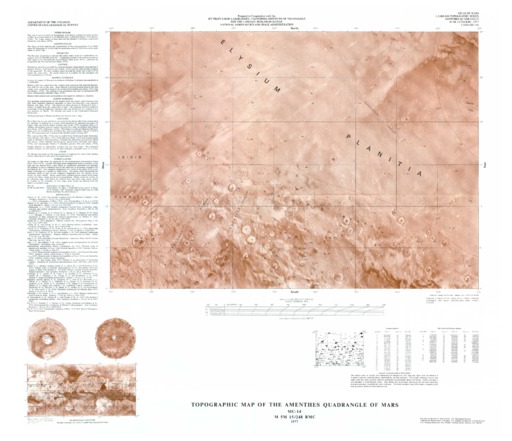
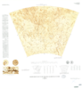
Mars Topographic Map of the Amenthes Quadrangle
Mimetype
application/pdf
Filename
Mars-Topographic-Map-of-the-Amenthes-Quadrangle.pdf
Publisher
USGS Astrogeology Science Center
Publication Date
16 October 1977
Originator
Group
RPIF
Added to Astropedia
3 May 2016
Modified
22 June 2021
General
Geospatial Data Presentation Form
Regional Mosaic
Series Id
1024
Keywords
Target
Mars
Theme
Cartography
,
Remote Sensing
,
Topography
Mission
Contact and Distribution
Access Instructions
1 map :col. ;53 x 37 cm. on sheet 86 x 71 cm. fold. in envelope 30 x 24 cm.
Geospatial Information
Minimum Latitude
0
Maximum Latitude
30
Minimum Longitude
90
Maximum Longitude
135
Quad Name
MC-14
FGDC:
xml metadata
Ancillary Data
Metadata
(xml) 1017 bytes
Related Products
Mars Shaded Relief Map
Mars Topographic Map of the Thaumasia Quadrangle
Mars Topographic Map of the Phaethontis Quadrangle
Mars Shaded Relief Map of the Thaumasia Quadrangle
Mars Shaded Relief Map of the Phaethontis Quadrangle
1
2
3
4
…
10
ISIS
Planetary Nomenclature
Map a Planet 2
PDS Cartography and Imaging Science Node
RPIF
Photogrammetry Guest Facility
PILOT
MRCTR GIS Lab