Mars Human Exploration Zone DEM Archive 2023
- Originators
- Day, M., Kim, E., Sullivan, M., Goudge, T., Paige, D.
- Publisher
- USGS Astrogeology Science Center
- Publication Date
- 2023-05-01
- Abstract
- This PDS4 archive includes 1,354 HiRISE DEMs, 1,354 CTX DEMs that overlap the HiRISE DEMs, orthoimages associated with each, and pixel masks to show the quality of each stereo correlation. DEMs locations were chosen from HiRISE targeted for collection in stereo, suggesting an existing scientific interest by the community specifically targeting potential human exploration zones. An additional method to see if a DEM is available in your area of interest, access the full DEM list and shapefile of HiRISE DEM and CTX DEM coverage at https://github.com/GALE-Lab/Mars_DEMs. PDS4 DOI: 10.17189/ervc-mr85 Access instructions: currently this archive is available from an Amazon S3 bucket. To access that please find the listing for each file above (or from this index.html listing). Example Amazon aws command-line options for listing or downloading this archive. Listing the archive: aws s3 ls --no-sign-request --recursive s3://asc-pds-individual-investigations/mars_mro_hirise_explorationzones_day_2023/ to copy the whole archive (to test, add --dryrun to command-line): aws s3 sync --no-sign-request s3://asc-pds-individual-investigations/mars_mro_hirise_explorationzones_day_2023/ /my/local/path/. Reference: Beyer, R.A., Alexandrov, O., and McMichael, S., 2018, The Ames Stereo Pipeline: NASA's open source software for deriving and processing terrain data: Earth and Space Science, v. 5, p. 537-548. Bemis, S.P., Micklethwaite, S., Turner, D., James, M.R., Akciz, S., Thiele, S.T., and Bangash, H.A., 2014, Ground-based and UAV-Based photogrammetry: A multi-scale, high-resolution mapping tool for structural geology and paleoseismology: Journal of structural geology, v. 69, p. 163-178. Shean, D.E., Alexandrov, O., Moratto, Z.M., Smith, B.E., Joughin, I.R., Porter, C., and Morin, P., 2016, An automated, open-source pipeline for mass production of digital elevation models (DEMs) from very-high-resolution commercial stereo satellite imagery: ISPRS Journal of Photogrammetry and Remote Sensing, v. 116, p. 101-117. Goudge, T.A., Mohrig, D., Cardenas, B.T., Hughes, C.M., and Fassett, C.I., 2018, Stratigraphy and paleohydrology of delta channel deposits, Jezero crater, Mars: Icarus, v. 301, p. 58-75. Ohman T., 2013, A beginner's guide to stereo-derived DEM production and analysis using ISIS, ASP, and ArcMap. Lunar and Planetary Institute, internal report, 30 pp., doi: 10.13140/RG.2.1.1743.7609. Available online at: http://www.lpi.usra.edu/lunar/tools/dems/Ohman_2013_ISIS-ASPArcMap_workflow.pdf Mayer, D.P., and Kite, E.S., 2016, An integrated workflow for producing digital terrain models of Mars from CTX and HiRISE stereo data using the NASA Ames Stereo Pipeline: LPI, p. 1241. Edmundson, K.L., Cook, D.A., Thomas, O.H., Archinal, B.A., and Kirk, R.L., 2012, Jigsaw: The SIS3 bundle adjustment for extraterrestrial photogrammetry: ISPRS Ann. Photogramm. Remote Sens. Spat. Inf. Sci, v. 1, p. 203-208. Smith, D.E., Zuber, M.T., Frey, H. V, Garvin, J.B., Head, J.W., Muhleman, D.O., Pettengill, G.H., Phillips, R.J., Solomon, S.C., and Zwally, H.J., 2001, Mars Orbiter Laser Altimeter: Experiment summary after the first year of global mapping of Mars: Journal of Geophysical Research: Planets, v. 106, p. 23689-23722.
- Purpose
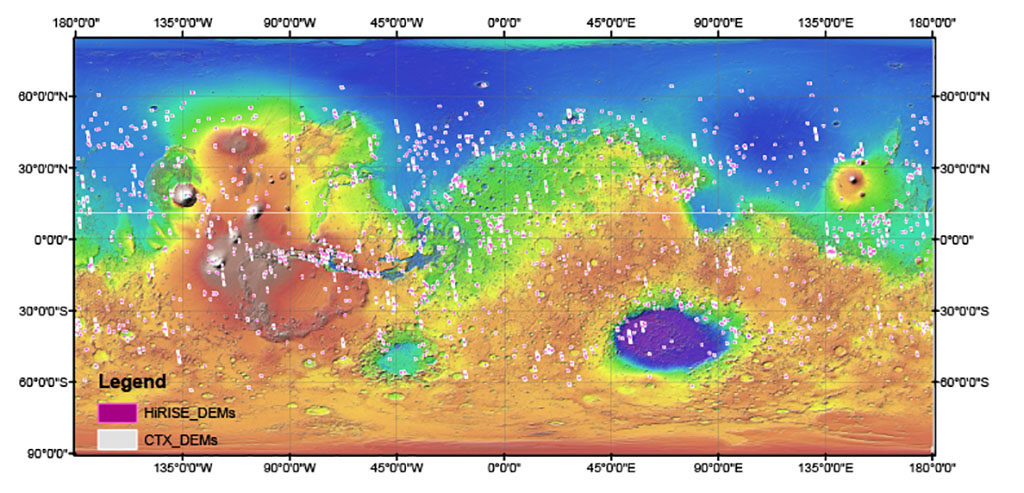
- Digital elevation models (DEMs) provide three-dimensional information about outcrops and landscapes that facilitate a range of scientific analyses not possible with imaging alone. For example, DEMs enable measurements of layer thickness and orientation that are critical to understanding local stratigraphy. On Mars, DEMs are currently available at a range of scales, and can be generated from stereo-pairs of images taken at different viewing angles. High resolution images produce high resolution DEMs, but not all stereo image pairs have been processed into three-dimensional products. This archive aims to bridge some of the gap between the available stereo imaging and the available DEMs. Roughly 2600 DEMs are included in this archive, half created using images from the High Resolution Imaging Science Experiment (HiRISE) and half using images from the Context Camera (CTX) aboard the Mars Reconnaissance Orbiter. CTX DEMs in this archive overlap one of the HiRISE DEMs, providing three-dimensional context, but at lower resolution, for the 1 m/px HiRISE DEMs. DEMs locations were chosen from HiRISE targeted for collection in stereo, suggesting an existing scientific interest by the community.
Contact and Distribution
- Format
- Digital Elevation Model, Raster Data, Remote-sensing Data
- Access Constraints
- Please cite authors
- Access Scope
- PDS
- Use Constraints
- None
- Supplemental Information
- https://github.com/GALE-Lab/Mars_DEMs
- Native Data Set Environment
- ESRI Arcinfo
- Astrogeology Theme
- Exploration, Image Processing, Remote Sensing, Topography
- Mission Names
- Mars Reconnaissance Orbiter
- Instrument Names
- CTX, HiRISE
- Online Package Link
- https://astrogeology.usgs.gov/search/map/mars_human_exploration_zone_dem_archive_2023
- External File Size
- 1.2 TB
- Online File Link
- https://asc-pds-individual-investigations.s3.us-west-2.amazonaws.com/mars_mro_hirise_explorationzones_day_2023/index.html
- Access Instructions
- This data is hosted in AWS cloud but typical downloads are allowed.
- Contact Address
- 2255 N. Gemini Drive
- Contact City
- Flagstaff
- Contact State
- AZ
- Contact Postal Code
- 86001
- Contact Email
- astroweb@usgs.gov
- Currentness Reference
- Publication date
- Progress
- Complete
- Update Frequency
- None planned
- Logical Consistency
- Data quality and limitations: Resolution: HiRISE DEMs have a post-spacing of 1 m and CTX DEMs a post-spacing of 18 m. The associated orthoimages have the same resolution (HiRISE and CTX at 1 m/px and 18 m/px, respectively). Quality evaluation and null values: Each DEM-orthoimage set is accompanied by a PNG file of the same naming convention, but appended with "Good Pixel Map". This standard product is used to evaluate the quality of the stereo correlation (see additional explanation in Beyer et al. (2018)). The Good Pixel Map is a pixel mask showing regions where the stereo correlation as successful (grey) and regions where it was not (red). Rather than interpolate across zones where the image correlation was unsuccessful, the data in this archive instead leave these regions blank and leave it to the user to interpolate via whatever method they wish. Regions of poor correlation are stored as null values and appear as "NoData" when viewed by GIS software. Projection information: The orthoimages and DEMs are projected to the Mars aeroid using the GCS_Mars_2000_Sphere georeferencing standard and the IAU D_MARS datum. Within a folder the files are arranged alphabetically, but a given set includes: 1 HiRISE DEM file (HiRISE1_HiRISE2_tied-DEM.tif), 1 HiRISE orthoimage file (HiRISE1_HiRISE2_tied-DRG.tif), 1 Good Pixel Map for the HiRISE DEM (HiRISE1_HiRISE2-GoodPixelMap.png), 1 CTX DEM file (CTX1_CTX2_tied-DEM.tif), 1 CTX orthoimage file (CTX1_CTX2_tied-DRG.tif), 1 Good Pixel Map for the CTX DEM (CTX1_CTX2- GoodPixelMap.png) XML files matching with each of the above. Example: "esp_049629_1375_esp_049563_1375_tied-dem.tif" For the example above, the product was generated from two HiRISE images: ESP_049629_1375 and ESP_049563_1375. The file name begins with the two image IDs, and ends with the type of product: in this case, a DEM already tied to the associated CTX. To find the associated CTX DEM, one could search for either HiRISE ID in the top level index (dem_index.csv) and find that this HiRISE DEM is associated with CTX images J12_049629_1376_XN_42S158W and J12_049563_1376_XN_42S158W. The index would also provide the center latitude and longitude of ESP_049629_1375 and the SetID# for this group of data products. In the folder indicated by that number, one could find the CTX DEM overlapping the HiRISE DEM and would expect it to have filename: j12_049629_1376_xn_42s158w_j12_049563_1376_xn_42s158w_tied-dem.tif
- Completeness Report
- Selection criteria: The DEMs created for this work met the following criteria: 1. HiRISE images were collected intentionally in stereo, meaning overlapping images were captured at geometries well-suited for generating DEMs using photogrammetry 2. CTX images overlapping the HiRISE stereo pair were collected during the same orbit and at similar geometries (i.e., âride alongâ observations with the original HiRISE), such that the HiRISE image pair and associated CTX image pair have similar relative geometries. 3. The center latitudes of the HiRISE image pair are equatorial of 65 degrees latitude A total of 1, 353 HiRISE stereo pairs meeting these criteria were successfully turned into DEMs archived in this bundle. Each HiRISE DEM is associated with an orthoimage (DRG), overlapping CTX DEM and DRG covering a larger area than the HiRISE DEM, and pixel masks that show the quality of the stereo correlation.
- Process Description
- The process of generating DEMs from overlapping images collected at dissimilar geometries (stereo images) is reviewed in the literature (Bemis et al., 2014; Shean et al., 2016), with several works providing guidance specifically for planetary data analysis (e.g., Ohman, 2013). We briefly review the steps taken in to generate the products in this archive. DEMs in this archive were generated using the open source Ames Stereo Pipeline (ASP; Shean et al., 2016; Beyer et al., 2018), which interfaces with the freely available Integrated Software for Imagers and Spectrometers (ISIS3) developed by the USGS (Edmundson et al., 2012). EDR files for each image in the stereo pair are downloaded and ingested through ISIS3. For HiRISE, EDRs are processed into a single mosaic using ASP. The images are then projected to the same reference frame (local sinusoidal projection), and then the ASP stereo correlation is run on the two projected images. This results in an orthoimage (digitally rectified graphic; DRG) and a point cloud of elevations. The point cloud is then tied to a lower-resolution elevation dataset. Elevation point clouds generated from CTX images are tied to elevations from the Mars Orbiter Laser Altimeter (MOLA; Smith et al., 2001), and point clouds generated from HiRISE are tied to the associated CTX point cloud (e.g., Mayer and Kite, 2016). Point clouds are then converted into DEMs and saved as GeoTIFF files. Associated XML files are added to the DEMs and DRGs per PDS4 standard guidelines.
- Source Title
- CTX and HiRISE Archives
- Source Online Linkage
- https://pds-geosciences.wustl.edu/missions/mro/
- Source PDS Archive
- Mars Reconnaissance Orbiter
- PDS Status
- PDS 4 Archived
- Type of Source Media
- Online
- Attribute Accuracy Report
- Accurate to Control Net
Geospatial Information
- Target
- Mars
- System
- Mars
- Direct Spatial Reference Method
- Raster
- Object Type
- Grid Cell
- Bit Type (8, 16, 32)
- 32
- Quad Name
- Radius A
- 3396190
- Radius C
- 3396190
- Control Net
- MOLA
- Bands
- 1
- Vertical Coordinate System Units
- Meters
- Map Projection Name
- Equirectangular
- Latitude Type
- Planetocentric
- Longitude Direction
- Positive East
- Longitude Domain
- -180 to 180