The Mars Global Digital Dune Database (MGD3)
The Mars Global Digital Dune Database (MGD3)was compiled and released in three parts, encompassing the area from latitude 65°N to 65°S, from 60°N to 90°N (the north polar region), and from 60° to 90°S (south polar region). All the remote sensing data for both GIS and non-GIS users is available online in three U.S. Geological Survey Open File Reports. To download the datasets and instructions for reading and using, see the links below. The MGD3 is also available as a layer on the Java Mission-planning and Analysis for Remote Sensing (JMARS) geospatial information system at the JMARS ASU website.
Current releases of THEMIS infrared (IR) images (100 m/px resolution) provide nearly complete coverage of the Martian surface. As such, these images can robustly serve as a basis for a planet-wide inventory of moderate to large-scale dune deposits. Within a global context, dune forms and regional distributions can easily be compared to global datasets (e.g., Mars Orbiter Laser Altimeter (MOLA) elevations and Thermal Emission Spectrometer (TES) derived thermal inertia values) and models (e.g. General Circulation Models (GCMs)) to provide a better understanding of the planet-wide processes that have shaped the Martian surface.
The digital dune database makes it possible to look at dunes in a global context, comparing their geographic location and attributes to other global coverages, such as geologic maps, GCMs, MOLA and TES. Such comparisons provide significant perspective on local, regional, and global-scale aeolian processes that have shaped and continue to influence the surface of Mars.
The Mars Global Digital Dune Database has been one of the primary driving factors for the Mars-Dunes Consortium.
The MGD3 includes seven major data layers: 1) The Dune Field feature class (polygon) includes ~550 dune fields on Mars between +65 and -65. 2) The Crater feature class (polygon) includes ~ 400 craters on Mars between +65 and -65 that are occupied by dune fields in the database. 3) and 4) The Crater centroid to Dune centroid Azimuth feature class (polyline and point versions) is based on polylines that extend from crater centroid to the centroid of a dune field within the crater on Mars between +65 and -65. 5) The Raw Slipface feature class (polyline) includes >10,000 polylines that were digitized on slipfaces, based on gross morphology of dunes, to represent wind direction responsible for that morphology. 6) The Average Slipface Azimuth feature class (point) was created by averaging raw slipface azimuths for the ~ 200 dune fields in which measurements were possible. Dune fields with multidirectional winds have more than one average, resulting in ~270 average slipface azimuths. 7) The GCM feature class (polyline) represents output from the Ames Mars General Circulation Model (GCM) for the area from +70 to -70. Only output records with a shear stress value > .0225 N/m2 are included.
Where are Dunes Found on Mars?
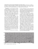
MGD3is complete for the +65 to -65 portion of Mars. The distribution of the dunes can be seen in the above map of that region (top). The database is in progress for the -65 to -90 portion of Mars. The distribution of possible dunes is shown in the table below. Based on possible dunes, the total dune field area in the -65 to -90 area is estimated to be about 50,000 km2. The map of +65 to +90, above right, shows the possible location of dunes. An areal estimate of dune fields is not yet available for that region.
| Latitudinal Region | Number of Dune Fields | % of Total Number of Dune Fields | Area of Dune Fields (km2) | % of Total Area |
|---|---|---|---|---|
| 30° to 65° N | 9 | 1.6 | 1507 | 2.2 |
| 0° to 30° N | 36 | 6.6 | 5165 | 7.4 |
| 0° to 30° S | 37 | 6.8 | 13,275 | 19.0 |
| 30° to 65° S | 465 | 85.0 | 49,803 | 71.4 |
| Total | 547 | 100 | 69,750 | 100 |
The following table summarizes the geographic distribution of the dunes in the database, (+65 to -65) by latitudinal band. Remember that only moderate to large dune fields are included in this database. The distribution of smaller dune fields may not follow this pattern.
The following table summarizes the quantity of dune fields in craters by number of dune fields and by area of dune fields for the Latitudinal bands and for the Argyre, Hellas and Valles Marineris regions.
| Latitudinal Region | Number of Dune Fields | Area of Dune Fields (km2) | Number of Dune Fields in Craters | Area of Dune Fields in Craters (km2) | % of Dune Fields in Craters (by area) |
|---|---|---|---|---|---|
| 0° to 30° S | 37 | 13,275 | 17 | 4326 | 32.6 |
| 30° to 65° S | 465 | 49,803 | 368 | 39,990 | 80.3 |
| Argyre and surrounding rough terrain | 47 | 5347 | 12 | 2453 | 45.9 |
| Hellas and surrounding rough terrain | 18 | 1310 | 2 | 87 | 6.6 |
| Valles Marineris | 20 | 8949 | 0 | 0 | 0 |
Instrumentation
Thermal Emission Imaging System - Infrared Band (THEMIS IR)
THEMIS IR images were chosen because they provided planet-wide coverage of Mars at a resolution (100 m/pixel) capable of revealing many dune features. Due to small particle size, dunes have a lower thermal inertia than surrounding rock, accompanied by a large diurnal temperature change. The dunes are relatively warm in the daytime images, appearing light in tone, making them easy to detect. In nighttime images the pattern reverses with the relatively cool dunes appearing dark.
Thermal Emission Imaging System - Visible Band (THEMIS Vis)
The higher resolution THEMIS VIS images are used, when available, to verify that the features are dunes and to classify the dune types.
Mars Orbital Camera (MOC)
Because of the higher spacial resolution, MOC images are used to identify and analyize slip faces and dune types.
High Resolution Imaging Science Experiment (HiRISE)
Though HiRISE images have not yet been used on the MGD3, these images shoudl offer even higher resolution that will better identify dune types, and should be able to show improved detail within the dunes.
Compact Reconnaissance Imaging Spectrometer for Mars (CRISM)
CRISM images, like HiRISE, have not yet been used for the MGD3. Also like HiRISE though, CRISM will offer greater detail and a better understanding of the dunes on Mars.