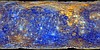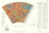
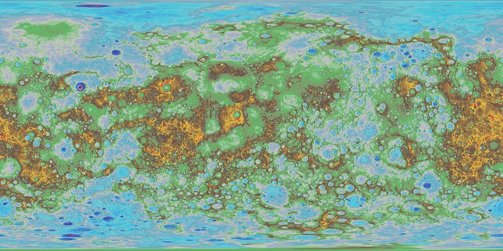
Mercury MESSENGER MDIS DEM Global Color Shaded Relief 2km
- Primary Authors
- USGS Astrogeology Science Center
- Originators
- NASA, Arizona State University, Johns Hopkins Applied Physics Laboratory, Carnegie Institution for Science
- Publisher
- USGS Astrogeology Science Center
- Publication Date
- 2016-05-06
- Abstract
- Product Information: This is a colorized shaded-relief of the original digital elevation model (DEM). Using the Integrated Software for Imagers and Spectrometers (ISIS3) and observations from Mercury Dual Imaging System (MDIS) narrow-angle camera (NAC) and multispectral wide-angle camera (WAC), we derived a global DEM of Mercury. We created the global DEM of Mercury from a least-squares bundle adjustment (jigsaw in ISIS3; Becker et al., 2016) of common features, measured as tie point coordinates in overlapping NAC and WAC-G filter images. The resolution of this DEM is 2 kilometers per pixel (km). The MDIS image inventory contains over 176,000 NAC and WAC-G observations with a very large variety of disparate geometric and illumination characteristics, and we encountered limitations to existing conventional control techniques in ISIS3 that required development of new software and techniques. Mission and Instrument Information: The MErcury Surface, Space Environment, Geochemistry, and Ranging (MESSENGER) spacecraft launched on August 3rd, 2004, it entered orbit around Mercury on March 11, 2011 and ended its mission on April 30th, 2015 when it deliberately plunged into the surface or Mercury. MESSENGER was the first spacecraft to orbit Mercury and had the primary goal of studying the geology, magnetic field, and chemical composition of the planet. The science payload onboard MESSENGER included: Mercury Dual Imaging System (MDIS), Gamma-Ray Spectrometer (GRS), Neutron Spectrometer (NS), X-ray Spectrometer (XRS), Mercury Laser Altimeter (MLA), Mercury Atmospheric and Surface Composition (MACS), Energetic Particle and Plasma Spectrometer (EPPS), and Radio Science experiment (RS). The MDIS instrument suite consists of wide-angle (WAC) and narrow-angle imagers (NAC) situated on a pivot platform that enables the instruments to be pointed in specified directions. References: Becker, K. J., Robinson, M. S., Becker, T. L., Weller, L. A., Edmundson, K. L., Neumann, G. A., Perry, M. E., et al. (2016). First global digital elevation model of Mercury. presented at the 47th Lunar and Planetary Science Conference, Lunar and Planetary Institute, Houston, TX. https://www.hou.usra.edu/meetings/lpsc2016/pdf/2959.pdf Hawkins, S. E., Boldt, J. D., Darlington, E. H., Espiritu, R., Gold, R. E., Gotwols, B., Grey, M. P., et al. (2007). The Mercury Dual Imaging System on the MESSENGER Spacecraft. Space Science Reviews, 131(1â4), 247â338. https://doi.org/10.1007/s11214-007-9266-3 Solomon, S. C., McNutt, R. L., Jr., Gold, R. E., Acuña, M. H., Baker, D. N., Boynton, W. V., Chapman, C. R., et al. (2001). The MESSENGER mission to Mercury: Scientific objectives and implementation. Planetary and Space Science, 49(14-15), 1445-1465. https://doi.org/10.1016/S0032-0633(01)00085-X
- Purpose
- A colorized and shaded representation of the original DEM to highlight elevation ranges for Mercury's topography.
Contact and Distribution
- Format
- Raster Data, Shaded-Relief Map, Topographic Map
- Access Constraints
- None
- Access Scope
- PDS
- Use Constraints
- Please cite authors
- Edition
- May 2016
- Edition Name
- MESSDEM_1001
- Supplemental Information
- http://messenger.jhuapl.edu/news_room/news-050616.html, http://www.usgs.gov/news/first-global-topographic-map-mercury-released, http://www.hou.usra.edu/meetings/lpsc2016/pdf/2959.pdf , http://messenger.jhuapl.edu/the_mission/mosaics.html
- Native Data Set Environment
- ISIS v3
- Astrogeology Theme
- Control Network, Image Processing, Remote Sensing, Topography
- Mission Names
- MESSENGER
- Instrument Names
- NAC, WAC
- Online Package Link
- https://astrogeology.usgs.gov/search/map/mercury_messenger_mdis_dem_global_color_shaded_relief_2km
- External File Size
- 84 MB
- Online File Link
- https://asc-astropedia.s3.us-west-2.amazonaws.com/Mercury/Topography/MESSENGER/ancillary/Mercury_Messenger_USGS_ClrShade_Global_2km.tif
- Access Instructions
- The main download, above, is defined using a Longitude range of 0 to 360 (center at 180). Here is an alternative download with the center set at 0 (longitude range = -180 to 180): https://asc-astropedia.s3.us-west-2.amazonaws.com/Mercury/Topography/MESSENGER/ancillary/Mercury_Messenger_USGS_ClrShade_Global_2km_clon0.tif
- Contact Address
- 2255 N. Gemini Drive
- Contact City
- Flagstaff
- Contact State
- AZ
- Contact Postal Code
- 86001
- Contact Email
- [email protected]
Data Status and Quality
- Time Period of Content (start)
- 2011-03-29
- Time Period of Content (stop)
- 2015-04-30
- Currentness Reference
- Ground condition
- Progress
- Complete
- Update Frequency
- As needed
- Process Description
- The original digital elevation model (DEM) is hillshaded and then colorized per elevation bin. Please see legend for mapping colors to elevation values (meters)
Lineage
- Process Date
- 2016-05-06
- Source Title
- MESSENGER Online Data Volumes
- Source Online Linkage
- http://pds-imaging.jpl.nasa.gov/volumes/mess.html,https://pds-imaging.jpl.nasa.gov/portal/messenger_mission.html
- Source PDS Archive
- MESSENGER
- PDS Status
- PDS 3 Archived
- Type of Source Media
- Online
- Attribute Accuracy Report
- Best Effort
- Horizontal Positional Accuracy Report
- Best Effort
- Vertical Positional Accuracy Report
- Best Effort
Geospatial Information
- Target
- Mercury
- Minimum Latitude
- -90
- Maximum Latitude
- 90
- Minimum Longitude
- 0
- Maximum Longitude
- 360
- Direct Spatial Reference Method
- Raster
- Object Type
- Grid Cell
- Raster Row Count (lines)
- 3832
- Raster Column Count (samples)
- 7664
- Bit Type (8, 16, 32)
- 8
- Quad Name
- Radius A
- 2439400
- Radius C
- 2439400
- Bands
- 3
- Pixel Resolution (meters/pixel)
- 2000
- Scale (pixels/degree)
- 21.287780886575
- Vertical Coordinate System Units
- Meters
- Map Projection Name
- Equirectangular
- Latitude Type
- Planetocentric
- Longitude Direction
- Positive East
- Longitude Domain
- 0 to 360