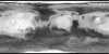
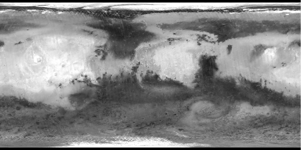
Mars MGS TES Global Bolometric Albedo Map 7410m
- Primary Authors
- Christensen, P., et al.
- Originators
- Arizona State University
- Publisher
- USGS Astrogeology Science Center
- Abstract
- Product Information: The Mars Global Surveyor (MGS) Thermal Emission Spectrometer (TES) has acquired a variety of observations, including broadband visible/near-IR (VISIR) data (0.3 to 2.9 micrometers) and broadband thermal IR data (5.1 to 150 micrometers) using bolometers, in addition to spectrometer observations covering 5.8 to 50 micrometers in wavelength (Christensen et al., 2001). The VISIR data have been reduced to Lambert albedo values and gridded at 8 pixels/degree (this data set). Also, night-time thermal measurements, daytime albedo data, and thermal modeling have been used to generate gridded estimates of surface thermal inertia. Pixel resolution is 7,410 meters per pixel (m). Mission and Instrument Information: Mars Global Surveyor (MGS) was the first successful U.S. mission launched to Mars since the Viking mission in 1976. MGS was launched on November 7, 1996, atop a three-stage Delta II launch vehicle from launch pad 17A at Cape Canaveral Air Station, FL. The thirdstage Star 48B solid rocket later propelled the spacecraft out of Earth orbit and on its way to Mars. After a 20-year absence at the planet, Mars Global Surveyor ushered in a new era of Mars exploration with its five science investigations (NASA JPL, 2010). MGS arrived at Mars in September, 1997 and has contributed a multitude of findings, including signs of past, persistent water such as an ancient delta and currently active water features in the gullies of canyon walls. After nearly a decade of discovery, MGS went silent in November, 2006 (NASA JPL, 2010). The MGS TES studied the atmosphere and mapped the mineral composition of the surface by analyzing infrared radiation, which scanned for heat emitted from the surface of Mars (NASA JPL, 2010). The TES has acquired a variety of observations, including broadband visible/near-IR (VISIR) data (0.3 to 2.9 micrometers) and broadband thermal IR data (5.1 to 150 micrometers) using bolometers, in addition to spectrometer observations covering 5.8 to 50 micrometers in wavelength (Christensen et al., 2001). The TES discovered new mineralogical and topographic evidence that suggested Mars had abundant water and thermal activity in its early history (NASA JPL, 2010). References: Christensen, P. R., Bandfield, J. L. Hamilton, V. E., Ruff, S. W., Kieffer, H. H., Titus, T. N., Malin, M. C., et al. (2001). Mars Global Surveyor Thermal Emission Spectrometer experiment: Investigation description and surface science results. Journal of Geophysical Research, 106(E10), 23823-23872. https://doi.org/10.1029/2000JE001370 National Aeronautics and Space Administration (NASA) Jet Propulsion Laboratory (JPL) (2010). Mars Global Surveyor. https://mars.nasa.gov/mgs/overview/
- Purpose
- Global map of thermal inertia of Mars.
Contact and Distribution
- Format
- Global Mosaic, Raster Data, Remote-sensing Data
- Access Constraints
- Public domain
- Access Scope
- PDS
- Use Constraints
- Please cite authors
- Edition
- 2001
- Supplemental Information
- http://pds-geosciences.wustl.edu/missions/mgs/index.htm, http://tes.asu.edu/
- Native Data Set Environment
- ISIS v3
- Astrogeology Theme
- Image Processing, Regolith, Remote Sensing
- Mission Names
- Mars Global Surveyor
- Instrument Names
- TES
- Online Package Link
- https://astrogeology.usgs.gov/search/map/mars_mgs_tes_global_bolometric_albedo_map_7410m
- External File Size
- 16 MB
- Online File Link
- https://planetarymaps.usgs.gov/mosaic/Mars_MGS_TES_Albedo_mosaic_global_7410m.tif
- Contact Address
- 2255 N. Gemini Drive
- Contact City
- Flagstaff
- Contact State
- AZ
- Contact Postal Code
- 86001
- Contact Email
- [email protected]
- Currentness Reference
- Publication date
- Progress
- Complete
- Update Frequency
- As needed
- Source Title
- TES Bolometric Albedo Global Map
- Source Online Linkage
- {http://geo.pds.nasa.gov/missions/mgs/tesspecial.html,http://pds-geosciences.wustl.edu/missions/mgs/index.htm,http://tes.asu.edu/data_archive.html}
- PDS Status
- PDS 3 Archived
Geospatial Information
- Target
- Mars
- System
- Mars
- Minimum Latitude
- -90
- Maximum Latitude
- 90
- Minimum Longitude
- -180
- Maximum Longitude
- 180
- Direct Spatial Reference Method
- Raster
- Object Type
- Grid Cell
- Raster Row Count (lines)
- 1440
- Raster Column Count (samples)
- 2880
- Bit Type (8, 16, 32)
- 32
- Quad Name
- Radius A
- 3396000
- Radius C
- 3396000
- Bands
- 1
- Pixel Resolution (meters/pixel)
- 7410
- Scale (pixels/degree)
- 8
- Map Projection Name
- Simple Cylindrical
- Latitude Type
- Planetocentric
- Longitude Direction
- Positive East
- Longitude Domain
- -180 to 180