Mars Sample Return Terrain Relative Navigation HiRISE DTM and Orthoimage Mosaics
- Originators
- USGS Astrogeology Science Center
- Publisher
- USGS Astrogeology Science Center
- Publication Date
- 2025-02-28
- Abstract
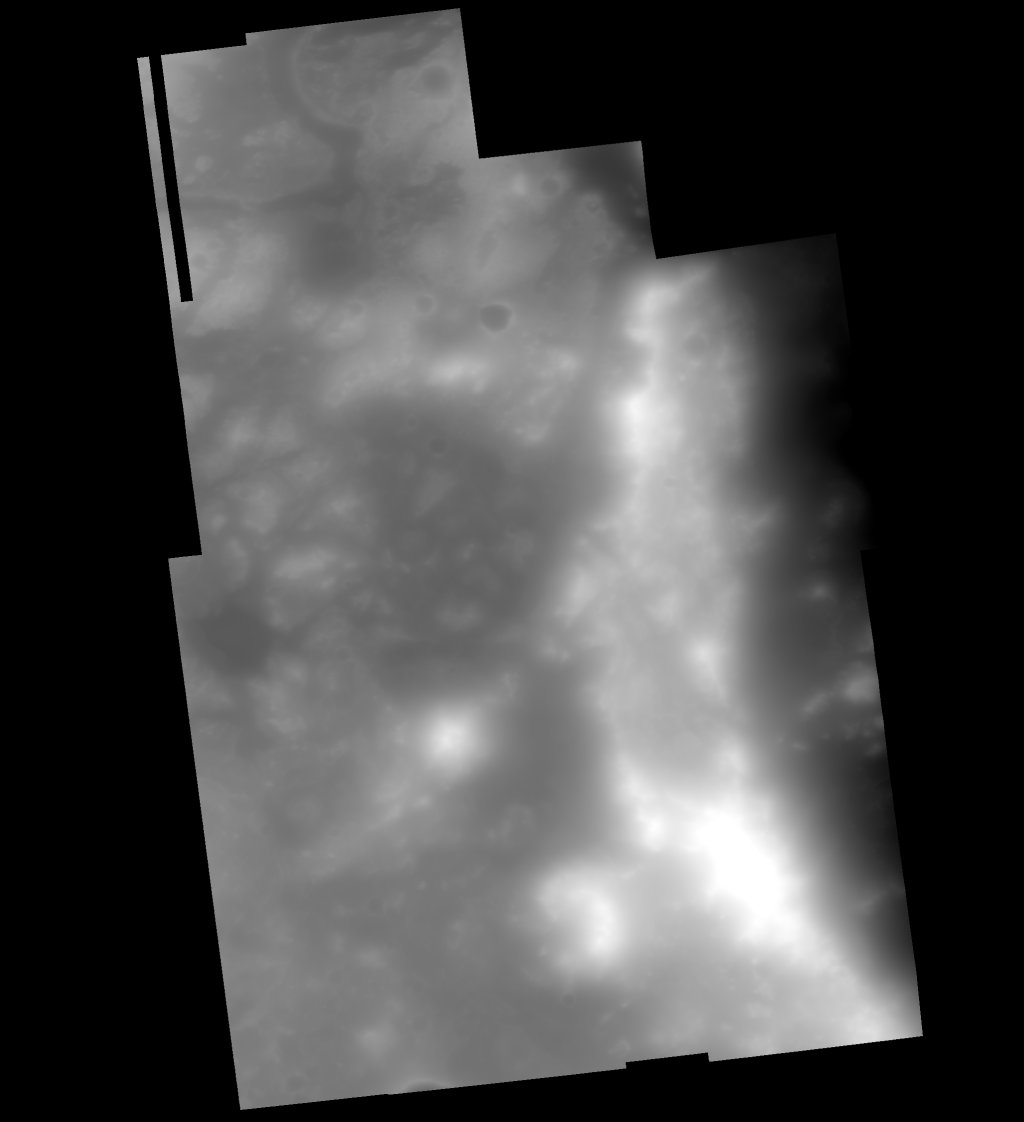
- The main download (above) contains the created DTM, Orthoimage, and Confidence mosaics as a zip file. Background: In order to support the landing and operations of NASA Mars 2020 Perseverance rover, the U.S. Geological Survey (USGS) previously generated Digital Elevation Model (DEM) and orthoimage mosaics of the floor of Jezero crater. Over four years of operations, Perseverance has collected numerous samples while climbing the western rim of Jezero and has travelled beyond the extent of the existing DEM products. Continued operations of Perseverance, and the eventual return of samples from on-board the rover (i.e., Mars Sample Return – MSR), require a new set of high-fidelity cartographic products that extend westward from the floor of Jezero crater and include regions within the rover’s potential traverse path. In 2023-2024, the Jet Propulsion Laboratory (JPL) worked in coordination with the USGS Astrogeology Science Center to generate new DEM and orthoimage mosaics from 8 High Resolution Imaging Science Experiment (HiRISE) stereo pairs covering this region. The DEM and orthoimage mosaics are rigorously aligned to the existing DEMs of Jezero crater and are fit for rover navigation and hazard mapping to within the accuracies described below, and the limitations (pixel scale and post spacing) of the data. The individual images used in the mosaics are available for download from here (13.2 GB) Citation: Bland, M. T., Galuszka, D. M., Hare, T. M., Mayer, D. P., Redding, B. L., Wheeler, B. H., 2024, Mars Sample Return Terrain Relative Navigation HiRISE DTM and Orthoimage Mosaics, USGS Data Release, https://doi.org/10.5066/P13CPYYU DOI: https://doi.org/10.5066/P13CPYYU References: USGS Science Base (alternative access): https://www.sciencebase.gov/catalog/item/67a2a012d34e05baae1c87e7 Bland, et. al., 2025, HiRISE Digital Elevation Model and Orthoimage Mosaics in Support of Perseverance Operations and Mars Sample Return, 56th Lunar and Planetary Science Conference, URL: https://www.hou.usra.edu/meetings/lpsc2025/pdf/1627.pdf. Fergason, R. L., Hare, T. M., Mayer, D. P., Galuszka, D. M., Redding, B. L., Smith, E. D., Shinaman, J. R., Cheng, Y., Otero, R. E., 2020, Mars 2020 Terrain Relative Navigation Flight Product Generation: Digital Terrain Model and Orthorectified Image Mosaics, 51st Lunar and Planetary Science Conference, URL: https://www.hou.usra.edu/meetings/lpsc2020/pdf/2020.pdf. McEwen, A.S. et al., 2007, Mars Reconnaissance Orbiter's High Resolution Imaging Science Experiment (HiRISE), J. Geophys. Res. 112, E05S04, URL: https://doi.org/10.1029/2005JE002605.
- Purpose
- The purpose of this work was to generate and a High-Resolution Imaging Science Experiment (HiRISE) DTM and orthoimage mosaics to support Mars Sample Return Entry, Decent, and Landing simulation testing and to generate individual HiRISE DTMs to serve as a foundation for ortho-projection and control of the HiRISE orthoimages used in the orthoimage mosaic.
Contact and Distribution
- Format
- Digital Elevation Model, Data, Grey Scale, Merge, Raster Data, Regional Mosaic, Remote-sensing Data, Topographic Map
- Access Constraints
- None
- Access Scope
- Photogrammetry
- Use Constraints
- Please cite authors
- Supplemental Information
- https://doi.org/10.1029/2005JE002605, https://www.hou.usra.edu/meetings/lpsc2025/pdf/1627.pdf
- Native Data Set Environment
- GDAL
- Astrogeology Theme
- Cartography, Control Network, Geographic Information System (GIS), Geomorphology, Geophysical, Image Processing, Impact Crater, Landing sites, Photogrammetry, Remote Sensing, Roving vehicles, Sampling and analysis, Terrestrial planets
- Mission Names
- Mars 2020
- Mission Specific
- Mars Sample Return (MSR)
- Instrument Names
- HiRISE
- Digital Product?
- yes
- Online Package Link
- https://astrogeology.usgs.gov/search/map/mars-sample-return-terrain-relative-navigation-hirise-dtm-mosaic
- External File Size
- 5.3GB
- Online File Link
- https://asc-pds-services.s3.us-west-2.amazonaws.com/mosaic/Mars/MSR_TRN_HiRISE_soc_003_USGS_release_aug2024/MSR_TRN_HiRISE_soc_003_USGS_release_aug2024_mosaics.zip
- Access Instructions
- Download and uncompress zip file to access GeoTIFFs
Data Status and Quality
- Time Period of Content (start)
- 2023-05-01
- Time Period of Content (stop)
- 2024-09-30
- Currentness Reference
- Publication date
- Progress
- Complete
- Update Frequency
- None planned
- Logical Consistency
- The horizontal alignment between individual HiRISE DEMs is better than 0.9 m at the 99th percentile in both X and Y directions (in some cases, significantly better). The vertical offset between HiRISE DEMs is < 2.3 m at the 99th percentile, with a notable exception on the crater rim of Jezero. The offset is not correlated with topography and its cause remains elusive. The HiRISE mosaic is aligned to the CTX reference to < 6 m, but only at the 93rd percentile. At the 99th percentile, the alignment is only < 10.2 m.
- Completeness Report
- 8 stereo-pairs of 10 were completed for the project.
- Process Description
- We generated this new DEM by first generating ten individual DEMs using BAE’s SOCET SET® software. The images in each pair were horizontally aligned to each other and vertically aligned to Mars Orbiter Laser Altimeter (MOLA) shot data. A preliminary DEM was then extracted and rigidly aligned to the existing Mars 2020 CTX DEM, which was used as our reference, using ASP’s pc_align application. This permitted an assessment of long-wavelength distortions, which were then minimized through a combination of tie point adjustment and modification of initial ground point heights based on the reference DEM. The image pair was then re-bundle adjusted, and a final DEM was extracted. Eight of those DEMs were combined into a single mosaic by adding tie points between overlapping segments and additional ground points between each DEM and the reference DEM. Joint bundle adjustment was performed to minimize offsets between adjacent HiRISE DEMs and between the HiRISE DEM and the reference DEM. Once alignment requirements were met (described next section), the individual DEMs were manually edited to correct blunders and textural artifacts. An affine transform was applied to the mosaics to bring them into final alignment with the CTX reference. Radiometric balancing and seam blending was then performed to create a visually uniform final product.
Lineage
- Process Date
- 2024-09-30
- Source Name or Organization
- Planetary Data System
- Source Publication Date
- 2025-02-04
- Source Title
- Mars Reconnaissance Orbiter's High Resolution Imaging Science Experiment (HiRISE)
- Source Online Linkage
- https://pds-imaging.jpl.nasa.gov/volumes/mro.html
- Source PDS Archive
- Mars Reconnaissance Orbiter
- PDS Status
- Locally Archived
- Type of Source Media
- Online
- Horizontal Positional Accuracy Report
- Accurate to Control Net
- Vertical Positional Accuracy Report
- Accurate to Control Net
Geospatial Information
- Target
- Mars
- System
- Mars
- Feature Name
- Jezero crater
- Location Description
- Jezero crater
- Minimum Latitude
- 18.135
- Maximum Latitude
- 18.588
- Minimum Longitude
- 77.057
- Maximum Longitude
- 77.380
- Direct Spatial Reference Method
- Raster
- Object Type
- Pixel
- Raster Row Count (lines)
- 19144
- Raster Column Count (samples)
- 26816
- Bit Type (8, 16, 32)
- 32
- Radius A
- 3396190.0
- Radius C
- 3396190.0
- Control Net
- MOLA
- Bands
- 1
- Pixel Resolution (meters/pixel)
- 1
- Scale (pixels/degree)
- 59274.69
- Horizontal Coordinate System Units
- Meters
- Vertical Coordinate System Units
- Meters
- Map Projection Name
- Equirectangular
- Latitude Type
- Planetocentric
- Longitude Direction
- Positive East
- Longitude Domain
- -180 to 180