Lorenz et al. 2013 Titan Topographic Map of Titan
- Primary Authors
- Ralph D. Lorenz
- Originators
- USGS Astrogeology Science Center
- Publisher
- USGS Astrogeology Science Center
- Abstract
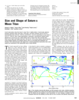
- Cassini RADAR SARtopo and altimetry data are used to construct a global gridded 1 x 1° elevation map, for use in Global Circulation Models, hydrological models and correlative studies. The data are sparse, and so most of the map domain (~90%) is populated with interpolated values using a spline algorithm. The highest (~+520 m) gridded point observed is at 48°S, 12°W. The lowest point observed (~1700 m below a 2575 km sphere) is at 59°S, 317°W: this may be a basin where liquids presently in the north could have resided in the past. If the deepest point were once a sea with the areal extent of present-day Ligeia Mare, it would be ~1000 m deep. We find four prominent topographic rises, each ~200 km wide, radar-bright and heavily dissected, distributed over a ~3000 km arc in the southeastern quadrant of Titan (~40â60°S, 15â150°W).
Contact and Distribution
- Format
- Document
- Access Scope
- Native Data Set Environment
- Astrogeology Theme
- Topography
- Mission Names
- Cassini-Huygens
- Online Package Link
- https://astrogeology.usgs.gov/search/map/lorenz_et_al_2013_titan_topographic_map_of_titan
- External File Size
- 7355273
- Online File Link
- http://astropedia.astrogeology.usgs.gov/download/Titan/Cassini/GTDR/Lorenz_etal_2013_Titan_topomap.pdf
- Contact Address
- 2255 N. Gemini Drive
- Contact City
- Flagstaff
- Contact State
- AZ
- Contact Postal Code
- 86001
- Contact Email
- astroweb@usgs.gov
Geospatial Information
- Target
- Titan
- System
- Saturn
- Object Type
- Grid Cell
- Quad Name
- Horizontal Coordinate System Units
- Degrees