Initial Global Control Network and Moasicking of ISS Images of Titan
- Originators
- USGS Astrogeology Science Center
- Publisher
- USGS Astrogeology Science Center
- Abstract
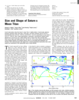
- The Cassini mission has returned an abundance of data about the surface of Titan. To maximize the science return from these data and to assist with planning for Cassini and future missions, we have begun the process of rigorously registering images and ancillary data from Cassini's ISS and RADAR instruments into a single, consistent, precise global Titan reference frame and have created the first controlled near global (all longitudes, +45° to -65° latitude) ISS mosaic of Titan. This has been done via a controlled, photogrammetric least squares bundle adjustment. B. A. Archinal, T. L. Becker, E. M. Lee, K. L. Edmundson (2013) Initial Global Control Network and Mosaicking of ISS Images of Titan, Proceedings of the 44th Lunar and Planetary Science Conference, 2013 March 18-22, The Woodlands, Texas, abstract no. 2957. Available from http://www.lpi.usra.edu/meetings/lpsc2013/pdf/2957.pdf.
Contact and Distribution
- Format
- Document
- Access Scope
- Astrogeology
- Native Data Set Environment
- Mission Names
- Cassini-Huygens
- Instrument Names
- ISS
- Online Package Link
- https://astrogeology.usgs.gov/search/map/initial_global_control_network_and_moasicking_of_iss_images_of_titan
- External File Size
- 460512
- Online File Link
- http://astropedia.astrogeology.usgs.gov/download/Titan/Cassini/Global-Mosaic/2957.pdf
- Contact Address
- 2255 N. Gemini Drive
- Contact City
- Flagstaff
- Contact State
- AZ
- Contact Postal Code
- 86001
- Contact Email
- astroweb@usgs.gov
Geospatial Information
- Target
- Titan
- System
- Saturn
- Object Type
- Grid Cell
- Quad Name
- Horizontal Coordinate System Units
- Degrees