Io Galileo SSI Tvashtar Paterae DEM and Orthoimages 900m
- Primary Authors
- Colin Dundas
- Originators
- Donna Galuszka, Emery Littlefield, Annie Howington-Kraus
- Publisher
- USGS Astrogeology Science Center
- Publication Date
- 2017-09-01
- Abstract
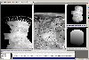
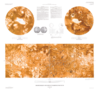
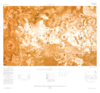
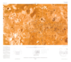
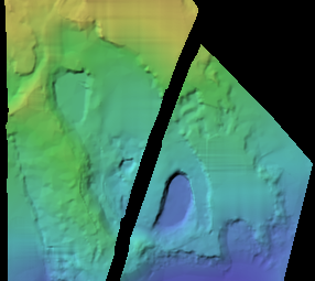
- Product Information: This uncontrolled Digital Elevation Model (DEM) was created to investigate the terrain of the Tvashtar Paterae volcanic region on Io, using stereo imagery from the Galileo spacecraft's Solid-State Imaging (SSI) camera. The DEM was created from Galileo images 5700r, 5713r, and 9426r and has a resolution of 900 meters per pixel (m). Mission and Instrument Information: Galileo launched on October 18, 1989 from the Kennedy Space Center in Florida aboard the space shuttle Atlantis with the aim to study Jupiter and its moons. It arrived at Jupiter on December 7th, 1995 and ended when the spacecraft entered Jupiterâs atmosphere on September 21, 2003. Galileo made seven flybys of Io during its fourteen-year mission in the Jovian system. The Solid-State Imaging (SSI) experiment was designed to study Jupiter and itâs satellites using multi-spectral, high-resolution, charge-coupled device (CCD) camera. The camera was operated in eight filtered band passes from 350-1100nm, the eight -position filter wheel consisted of three broad-band filters: violet(404nm), green(559nm), and red(671nm). The borad-band filters allowed for the reconstruction of visible color photographs. The use of a CCD permitted the SSI to have an image geometry which was independent of brightness gradients, greater sensitivity to incident photons, and a wider spectral range than any camera previously flown on a planetary mission. Reference and Preferred Citation: Dundas, C. M. (2017). Effects of lava heating on volatile-rich slopes on Io. Journal Geophysical Research: Planets, 122(3), 546-559. https://doi.org/10.1002/2016JE005177 File names and description: * TvashtarPaterae_5700r_Ortho_185m.tif, TvashtarPaterae_5713r_Ortho_185m.tif, TvashtarPaterae_9426r_Ortho_319m.tif : GeoTiff (and ISIS3/PDS3 labels) for orthorectified gray scale images. The first two have a pixel scale of 185 m and the third has a pixel scale of 319 m. * TvashtarPaterae_DEM_900m.tif: GeoTiff (and ISIS3/PDS3 labels) file with the DEM numerical values as an image. * TvashtarPaterae_ClrShade_900m.tif: GeoTiff (and ISIS3/PDS3 labels) file as a colorized hillshade of the original DEM. Legend is also available.
- Purpose
- This DEM is intended for scientific study of the Tvashtar Paterae volcanic system.
Contact and Distribution
- Format
- Digital Elevation Model, Image, Regional Mosaic, Shaded-Relief Map, Topographic Map
- Access Constraints
- Please cite authors
- Access Scope
- PDS
- Use Constraints
- None
- Supplemental Information
- http://dx.doi.org/10.1002/2016JE005177
- Native Data Set Environment
- GDAL, ISIS v3
- Astrogeology Theme
- Image Processing, Photogrammetry, Remote Sensing, Topography, Volcanism
- Mission Names
- Galileo
- Instrument Names
- SSI
- Online Package Link
- https://astrogeology.usgs.gov/search/map/io_galileo_ssi_tvashtar_paterae_dem_and_orthoimages_900m
- External File Size
- 1 MB
- Online File Link
- https://planetarymaps.usgs.gov/mosaic/Io/TvashtarPaterae_DEM/TvashtarPaterae_DEM_900m.tif
- Contact Address
- 2255 N. Gemini Drive
- Contact City
- Flagstaff
- Contact State
- AZ
- Contact Postal Code
- 86001
- Contact Email
- [email protected]
- Progress
- Complete
- Update Frequency
- None planned
- Process Description
- The DEM was created via analysis of stereo imagery. Rather than absolute control to a global topographic base, the DEM was adjusted such that the floor of the deepest patera was approximately level. This is likely to be approximately correct since the floor is thought to be flooded by lava. Small inaccuracies can result in a systematic long-baseline tilt which is likely the cause of the south-to-north slope. The DEM was hand-edited locally to improve the quality. However, residual errors may remain, particularly in the vicinity of active lava that was present in the eastern part of the region during data acquisition. The reference elevation (zero) is arbitrary. Because there is a narrow gap between images 5700r and 5713r, the separated portions of overlap coverage were aligned by hand. Users should be aware of these issues and ensure that they do not compromise the intended use.
- Source Title
- Planetary Data System, Cartography and Imaging Sciences Node, Galileo SSI Archive
- Source Online Linkage
- {https://pds-imaging.jpl.nasa.gov/portal/galileo_mission.html,https://pds-imaging.jpl.nasa.gov/volumes/galileo.html#gllSSIREDR}
- Source PDS Archive
- Galileo
- PDS Status
- PDS 4 In Progress
- Attribute Accuracy Report
- Unknown
- Horizontal Positional Accuracy Report
- Unknown
- Vertical Positional Accuracy Report
- Unknown
Geospatial Information
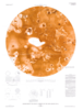
- Target
- Io
- System
- Jupiter
- Feature Name
- Tvashtar Paterae
- Minimum Latitude
- 55.61571649
- Maximum Latitude
- 73.7626619
- Minimum Longitude
- -128.5941
- Maximum Longitude
- -110.27389
- Direct Spatial Reference Method
- Raster
- Object Type
- Grid Cell
- Raster Row Count (lines)
- 641
- Raster Column Count (samples)
- 286
- Bit Type (8, 16, 32)
- 32
- Quad Name
- Radius A
- 1821460
- Radius C
- 1821460
- Control Net
- None
- Bands
- 1
- Pixel Resolution (meters/pixel)
- 900.00000009557
- Scale (pixels/degree)
- 35.32274910000013
- Vertical Coordinate System Units
- Meters
- Map Projection Name
- Equirectangular
- Latitude Type
- Planetocentric
- Longitude Direction
- Positive East
- Longitude Domain
- -180 to 180