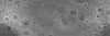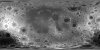

Moon LRO LOLA - SELENE Kaguya TC Shaded Relief Merge 60N60S 59m v1
Product Information:
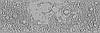
The Lunar Orbiter Laser Altimeter (LOLA) and SELenological and Engineering Explorer (SELENE) Kaguya Teams have created this shaded relief of the improved lunar digital elevation model (DEM) covering latitudes within ±60°, at a horizontal resolution of 512 pixels per degree (~59 meters per pixel [m] at the equator) and a typical vertical accuracy ~3 to 4 m.
This DEM is constructed from ~4.5×10⁹ geodetically-accurate topographic heights from the LOLA, to which we co-registered 43,200 stereo-derived DEMs (each 1°×1°) from the TC (~1010 pixels total). After co-registration, approximately 90% of the TC DEMs show root-mean-square vertical residuals with the LOLA data of <5 m compared to ~50% prior to co-registration. We use the co-registered TC data to estimate and correct orbital and pointing geolocation errors from the LOLA altimetric profiles (typically amounting to <10 m horizontally and <1 m vertically). By combining both co-registered datasets, we obtain a near-global DEM with high geodetic accuracy, and without the need for surface interpolation. We evaluate the resulting LOLA + TC merged DEM (designated as “SLDEM2015”) with particular attention to quantifying seams and crossover errors. Map values are referred to a radius of 1737400 m.
Mission and Instrument Information:
The U.S. National Aeronautics and Space Administration (NASA) launched the Lunar Reconnaissance Orbiter (LRO) spacecraft to the Moon in June 2009 (Tooley et al., 2010) carrying a variety of instruments that continue to return high-resolution images of the lunar surface from its eccentric polar mapping orbit (Petro et al., 2019).
The LOLA has collected over more than 6.5 billion measurements of global surface height with a vertical precision of ~10 cm and an accuracy of ~1m (Mazarico et al., 2013). With such highly accurate global coverage, the resulting topographic map has become the reference geodetic framework for the lunar community and has led to the highest resolution and most accurate polar DEMs to date (Barker et al., 2016).
The Japan Aerospace Exploration Agency (JAXA) launched the SELENE Kaguya spacecraft to the Moon in September 2007. The mission concluded June 10, 2009 when the spacecraft was intentionally crashed onto the lunar surface. Subsequent data collection and mapping efforts resulted in “the largest lunar exploration project since the Apollo program” (Haruyama et al., 2008).
The high-performance optical TC, a 10-meter spatial resolution stereo-camera, was part of the Lunar Imager/Spectrometer (LISM) instrument suite (Kato et al., 2006), along with the Multi-band Imager (MI, 20 m; (Ohtake et al., 2008) and Spectral Profiler (SP; Matsunaga et al., 2008).
SELENE is a Japanese mission developed and operated by JAXA. Please credit NASA's LOLA Team and JAXA's SELENE/Kaguya Team.
References:
Barker, M. K., Mazarico, E., Neumann, G. A., Zuber, M. T., Haruyama, J., & Smith, D. E. (2016). A new lunar digital elevation model from the Lunar Orbiter Laser Altimeter and SELENE Terrain Camera. Icarus, 273, 346–355. https://doi.org/10.1016/j.icarus.2015.07.039
Haruyama, J., Matsunaga, T., Ohtake, M., Morota, T., Honda, C., Yokota, Y., Torii, M., Ogawa, Y., & LISM Working Group (2008). Global lunar-surface mapping experiment using the Lunar Imager/Spectrometer on SELENE. Earth Planets Space, 60, 243-255. https://doi.org/10.1186/BF03352788
Kato, M., Takizawa, Y., Sasaki, S., & SELENE Project Team (2006). The SELENE Mission: Present status and science goals. Paper presented at the 38th Lunar and Planetary Science Conference, Lunar and Planetary Institute, Houston, TX. https://www.lpi.usra.edu/meetings/lpsc2007/pdf/1211.pdf
Matsunaga, T., Ohtake, M., Haruyama, J., Ogawa, Y., Nakamura, R., Yokota, Y., Morota, T., et al. (2008). Discoveries on the lithology of lunar crater central peaks by SELENE Spectral Profiler. Geophysical Research Letters, 35(L23201). https://doi.org/10.1029/2008GL035868
Ohtake, M., Haruyama, J., Matsunaga, T., Yokota, Y., Morota, T., Honda, C., & LISM Team (2008). Performance and scientific objectives of the SELENE (KAGUYA) Multiband Imager. Earth Planets Space, 60, 257-264. https://doi.org/10.1186/BF03352789
Petro, N. E., Keller, J. W., Cohen, B. A., & McClanahan, T. P. (2019). Ten years of the Lunar Reconnaissance Orbiter: Advancing lunar science and context for future lunar exploration. Paper presented at the 50th Lunar and Planetary Science Conference, Lunar and Planetary Institute, Houston, TX. https://www.hou.usra.edu/meetings/lpsc2019/pdf/2780.pdf
Tooley, C. R., Houghton, M. B., Saylor Jr., S. S., Peddie, C., Everett, D. F., Baker, C. L., & Safdie, K. N. (2010). Lunar Reconnaissance Orbiter mission and spacecraft design. Space Science Reviews, 150(1), 23–62. https://doi.org/10.1007/s11214-009-9624-4
- Publisher
- USGS Astrogeology Science Center
- Publication Date
- 8 September 2015
- Author
- LOLA Team and Kaguya Team
- Originator
- Group
- PDS
- Added to Astropedia
- 8 September 2015
- Modified
- 8 June 2021
General
- Purpose
This product was produced to generate a high-resolution global topographic model and geodetic framework that enables precise targeting, safe landing, and surface mobility to carry out exploratory activities. It can characterize the polar illumination environment, and images permanently shadowed polar regions of the Moon to identify possible locations of surface ice crystals in shadowed polar craters.
- Geospatial Data Presentation Form
- Topographic Map, Remote-sensing Data
- Edition
- Feburary 4, 2015
- Online Linkage
- https://planetarymaps.usgs.gov/mosaic/LolaKaguya_Topo/Lunar_LRO_LOLAKaguya_Shade_60N60S_512ppd.tif
- Native Data Set Environment
- ISIS v3, GDAL, ESRI Arcinfo
- Supplemental Information
- https://lola.gsfc.nasa.gov/, https://www.sciencedirect.com/science/article/pii/S0019103515003450?via%3Dihub, https://www.sciencedirect.com/science/article/pii/S0019103513002108, http://jda.jaxa.jp/en/service.php, https://pds-imaging.jpl.nasa.gov/documentation/PDS_KaguyaData_Jan.31.11.pdf, https://pds-imaging.jpl.nasa.gov/portal/lro_mission.html, https://pds-imaging.jpl.nasa.gov/portal/kaguya_mission.html, https://pds-imaging.jpl.nasa.gov/documentation/LISM-SPICE_Format_en_V01.3.pdf, https://pds-imaging.jpl.nasa.gov/documentation/LALT_Format_en_V01.pdf
Keywords
- System
- Earth
- Target
- Moon
- Theme
- Topography, Remote Sensing
- Mission
- Lunar Reconnaissance Orbiter, Kaguya
- Mission Specific
- Instrument
- LOLA, TC
Contact and Distribution
- Access Constraints
- public domain
- Use Constraints
- None
Data Status and Quality
- Currentness Reference
- Publication date
- Progress
- Complete
- Update Frequency
- As needed
- Logical Consistency Report
- To reduce the presence of the largest seams, the team replaced the most poorly fit ∼1% of tiles with the original LOLA-only DEMs with interpolation to fill gaps.
- Process Date
- 8 September 2015
- Process Description
The original DTM was shaded using the applicaiton GDALDEM with a azimuth of 270 and angle of 45 degrees from the horizon.
- Horizontal Positional Accuracy Value
- 10
- Horizontal Positional Accuracy Report
- Accurate to Control Net
- Vertical Positional Accuracy Value
- 4
- Vertical Positional Accuracy Report
- Accurate to Control Net
- Entity and Attribute Overview
- Shadedrelief, or hillshading, simulates shadows cast upon a raised topographic map, or more abstractly upon the planetary surface.
- Entity and Attribute Linkage
- http://www.gdal.org/gdaldem.html
Lineage
- PDS Status
- PDS 3 Like
- Source Originator
- Planetary Data System
- Source Publication Date
- 4 February 2015
- Source Online Linkage
- http://pds-geosciences.wustl.edu/lro/lro-l-lola-3-rdr-v1/lrolol_1xxx/data/sldem2015/, http://darts.isas.jaxa.jp/planet/pdap/selene/index.html.en, http://pds-geosciences.wustl.edu/missions/lro/lola.htm, http://www.kaguya.jaxa.jp/index_e.htm
- Type of Source Media
- Online
- Attribute Accuracy Report
- Accurate to Control Net
Geospatial Information
- Location Description
- Moon
- Minimum Latitude
- -60
- Maximum Latitude
- 60
- Minimum Longitude
- -180
- Maximum Longitude
- 180
- Direct Spatial Reference Method
- Raster
- Object Type
- Pixel
- Lines (pixels)
- 61440
- Samples (pixels)
- 184320
- Bit Type
- 8
- Quad Name
- Radius A
- 1737400
- Radius C
- 1737400
- Control Net
- LOLA
- Bands
- 1
- Pixel Resolution (meters/pixel)
- 59.2252938
- Scale (pixels/degree)
- 512
- Horizontal Coordinate System Units
- Meters
- Map Projection Name
- Equirectangular
- Latitude Type
- Planetocentric
- Longitude Direction
- Positive East
- Longitude Domain
- -180 to 180