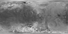

Iapetus Cassini - Voyager Global Mosaic 803m v1
Product Information:
This global map of Iapetus was created using images taken during Cassini spacecraft flybys, with Voyager images filling in the poles. The map is a Simple Cylindrical projection and has a resolution of 803 meters per pixel (m; 0.5 miles) and 16 pixels per degree. Some territory seen in this map was imaged by Cassini's cameras using reflected light from Saturn. The mean radius of Iapetus used for projection of this map is 736 kilometers (457 miles). This updated map has been shifted west by 4.5 degrees of longitude, compared to the previously released Cassini product (NASA JPL, 2008) in order to conform to the International Astronomical Union longitude system convention for Iapetus.
Mission and Instrument Information:
The Cassini-Huygens mission was a joint endeavor between the Italian Space Agency, the European Space Agency (ESA) and National Aeronautics and Space Administration (NASA). The Cassini-Huygens mission launched from Cape Canaveral Air Force Base in Florida on October 15, 1997 and ended on September 15, 2017 when Cassini began its Final Entry into Saturn’s atmosphere. The primary mission ran from July 2004 – June 2008. The first mission extension (Equinox) was from July 2008- October 2010 and was followed by a final extended mission (Solstice) from October 2010 – September 2017.
The Cassini Imaging Science Subsystem (ISS) consists of two framing cameras. The narrow angle camera is a reflecting telescope with a focal length of 2000 mm and a field of view of 0.35 degrees. The wide-angle camera is a refractor with a focal length of 200 mm and a field of view of 3.5 degrees. The stated objective of the ISS is to obtain global coverage for all medium-sized icy satellites with a resolution better than 1 km/pixel and high-resolution images of selected areas (Porco, 2004). This goal was achieved with image sequences obtained during close flybys supplemented by images from greater distances to complete the coverage (Roatsch, 2016)
The Voyager I spacecraft launched September 5, 1977 and passed through the Saturnian system on November 12, 1981. Voyager 2 launched August 20, 1977 and made a similar encounter with Jupiter on July 9th, 1979. The spacecraft carried both wide- and narrow- angle cameras, which were able to capture and return moderate- to high- resolution images of the satellites Rhea, Dione, Enceladus, Mimas, Tethys, and Iapetus. The rapid speed of the spacecraft as it approached the satellites resulted in significant mis-matches of image resolution and image blur (Greely & Batson, 2007; Batson, 1984).
References:
Batson, R. (1984). Voyager 1 and 2 Atlas of Six Saturnian Satellites (NASA-SP-474). Washington, DC: National Aeronautics and Space Administration (NASA). https://ntrs.nasa.gov/archive/nasa/casi.ntrs.nasa.gov/19840027171.pdf
Greely, R., & Batson, R. (2007). Planetary Mapping. (ISBN 0-521-30774-0). New York, NY: Cambridge University Press.
National Aeronautics and Space Agency (NASA) Jet Propulsion Laboratory (JPL) (2008). PIA08406: Map of Iapetus - January 2008. https://photojournal.jpl.nasa.gov/catalog/PIA08406
Porco C. C., West, R. A., Squyres, S., McEwan, A., Thomas, P., Murray, C. D., Delgenio, A., et al. (2004) Cassini Imaging Science: Instrument Characteristics and Anticipated Scientific Investigations at Saturn. In: Russell C.T. (eds) The Cassini-Huygens Mission. Springer, Dordrecht. https://doi.org/10.1007/1-4020-3874-7_6
Roatsch, T., Kersten, E., Matz, K.-D., Scholten, F., & Porco, C. C. (2016). Cartography of the medium-sized saturnian satellites based on Cassini-ISS images. Paper presented at the Enceladus and the Icy Moons of Saturn Conference, Lunar and Planetary Institute, Boulder, CO. https://www.hou.usra.edu/meetings/enceladus2016/pdf/3032.pdf
- Publisher
- Space Science Institute
- Originator
- Space Science Institute, Cassini Team, Jet Propulsion Laboratory
- Group
- PDS
- Added to Astropedia
- 13 January 2014
- Modified
- 25 May 2021
General
- Purpose
This pictorial map and controlled photomosaic of Iapetus was created as the first step of cartography planning in support of the Cassini-Huygens Mission to Saturn & Titan.
- Geospatial Data Presentation Form
- Global Mosaic, Remote-sensing Data, Raster Data
- Edition
- May 2008
- Online Linkage
- https://planetarymaps.usgs.gov/mosaic/Iapetus_Cassini_Voyager_mosaic_global_783m.tif
- Native Data Set Environment
- ISIS v3
- Supplemental Information
- http://www.ciclops.org/view/5221/Map_of_Iapetus_May_2008, https://solarsystem.nasa.gov/missions/cassini/overview/, http://ciclops.org
Keywords
Contact and Distribution
- Access Constraints
- Public domain
- Use Constraints
- Please cite authors
Data Status and Quality
- Update Frequency
- None planned
- Process Date
- 1 May 2008
Lineage
- PDS Status
- PDS 3 Like
- Source Originator
- Space Science Institute
- Source Title
- Map of Iapetus – May 2008
- Source Online Linkage
- https://pds-imaging.jpl.nasa.gov/volumes/iss.html, https://pds-imaging.jpl.nasa.gov/volumes/voyager.html#vgrISSEDR-J, https://pds-imaging.jpl.nasa.gov/portal/cassini_mission.html, https://pds-imaging.jpl.nasa.gov/portal/voyager_mission.html
- Type of Source Media
- Online
Geospatial Information
- Minimum Latitude
- -90
- Maximum Latitude
- 90
- Minimum Longitude
- -180
- Maximum Longitude
- 180
- Direct Spatial Reference Method
- Raster
- Object Type
- Pixel
- Lines (pixels)
- 2880
- Samples (pixels)
- 5760
- Bit Type
- 8
- Quad Name
- Radius A
- 736000
- Radius C
- 736000
- Bands
- 1
- Pixel Resolution (meters/pixel)
- 802.85145591739
- Scale (pixels/degree)
- 16
- Horizontal Coordinate System Units
- Meters
- Map Projection Name
- Simple Cylindrical
- Latitude Type
- Planetocentric
- Longitude Direction
- Positive West
- Longitude Domain
- -180 to 180