Products

86 Results Collapse
Mars 2020 Science Investigation CTX DEM Mosaic thumbnail

Mars 2020 Science Investigation CTX DEM Mosaic

image/tiff 204 kBOct 14 2021

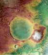
This product represents a CTX digital elevation model (DEM/DTM) mosaic at 20 m/pixel from stereo pairs covering Jezero crater. This mosaic includes the original Mars 2020 Jezero CTX TRN DEM but…

Io Galileo SSI Tvashtar Paterae DEM and Orthoimages 900m v1 thumbnail

Io Galileo SSI Tvashtar Paterae DEM and Orthoimages 900m v1

application/isis 1 kBSep 01 2017

Product Information: This uncontrolled Digital Elevation Model (DEM) was created to investigate the terrain of the Tvashtar Paterae volcanic region on Io, using stereo imagery from the Galileo…

Enceladus Cassini ISS Gridded Radius 2.2km v1 thumbnail

Enceladus Cassini ISS Gridded Radius 2.2km v1

application/isis 1 kBAug 28 2020

This 2.5D shape model of Enceladus was generated by interpolating the associated 3D point cloud of latitude, longitude, radius values, minus the mean radius of Enceldaus (251500 meters), to a regular…

ISPRS 2004 Landing Site Mapping and Rover Localization for the 2003 Mars Exploration rover Mission: Technology and Experimental Results thumbnail

ISPRS 2004 Landing Site Mapping and Rover Localization for the 2003 Mars Exploration rover Mission: Technology and Experimental Results

application/pdf 73 kB

This paper presents the technology and experimental results for high-precision landing-site mapping and rover localization developed for the ongoing 2003 Mars Exploration Rover (MER) mission. This…

ISPRS 2002 Photogrammetric Registration of MOC Imagery to MOLA Profile thumbnail

ISPRS 2002 Photogrammetric Registration of MOC Imagery to MOLA Profile

application/pdf 292 kB

The current Mars Global Survey (MGS) mission has been collecting high resolution digital images (MOC) and laser ranges (MOLA). The processing MOLA range data results in a global digital elevation…

ISPRS 2001 Utilizing Mars Digital Image Model (MDIM) and Mars Orbiter laser Altimeter (MOLA) data for photogrammetric control thumbnail

ISPRS 2001 Utilizing Mars Digital Image Model (MDIM) and Mars Orbiter laser Altimeter (MOLA) data for photogrammetric control

application/pdf 32 kB

The USGS is producing digital elevation models (DEM) and topographic maps of Mars at scales of 1:250,000 to 1:1,000,000. The initial source material will be Viking Orbiter images, with a later…

ISPRS 1999 Assessment of Published Viking Orbiter DEMs derived from Stereo Photogrammetry using MOLA Data thumbnail

ISPRS 1999 Assessment of Published Viking Orbiter DEMs derived from Stereo Photogrammetry using MOLA Data

application/pdf 2 MB

Described the exciting results which have been obtained from the initial set of mainly Northern hemispheric laser altimetry tracks from the MOLA instrument known as the SPO-1 phase. More recently has…

ISPRS 2002 USGS and DLR Topographic Mapping of Comet Borrelly thumbnail

ISPRS 2002 USGS and DLR Topographic Mapping of Comet Borrelly

application/pdf 500 kB

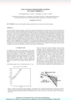
In the fall of 2001, NASA’s Deep Space 1 (DS1) probe imaged Comet Borrelly during a flyby encounter. Three of the Borrelly images have geometry suitable to photogrammetrically map the nucleus,…

ISPRS 2001 Combining Lunar Photogrammetric Topographic Data with Clementine LIDAR Data thumbnail

ISPRS 2001 Combining Lunar Photogrammetric Topographic Data with Clementine LIDAR Data

application/pdf 35 kB

During the Clementine Mission both oblique and vertical multispectral images were collected. The oblique and vertical images from a single spectral band collected during the same orbit form a stereo…

ISPRS 2004 Digital Cartography with HRSC on Mars Express thumbnail

ISPRS 2004 Digital Cartography with HRSC on Mars Express

application/pdf 8 MB

The High Resolution Stereo Camera (HRSC) on board of the European space mission Mars Express provides multispectral digital image data in high resolution as well as the systematic stereo coverage of…

Project Pages

4 Results Collapse

Documents

13 Results Collapse