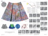
Venus Geologic Map of the Themis Regio Quadrangle
- Primary Authors
- Ellen R. Stofan and Antony W. Brian
- Originators
- E. Stofan, A. Brian
- Publisher
- USGS Astrogeology Science Center
- Publication Date
- 2012-02-12
- Abstract
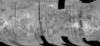
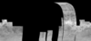
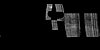
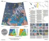
- The Themis Regio quadrangle (V-53), Venus, has been geologically mapped at 1:5,000,000 scale as part of the NASA Planetary Geologic Mapping Program. The quadrangle extends from lat 25° to 50° S. and from long 270° to 300° E. and encompasses the Themis Regio highland, the surrounding plains, and the southernmost extension of Parga Chasmata. Themis Regio is a broad regional topographic high with a diameter of about 2,000 km and a height of about 0.5 km that has been interpreted previously as a hotspot underlain by a mantle plume. The Themis rise is dominated by coronae and lies at the terminus of the Parga Chasmata corona chain. Themis Regio is the only one of the three corona-dominated rises that contains significant extensional deformation. Fractures and grabens are much less common than along the rest of Parga Chasmata and are embayed by corona-related flows in places. Rift and corona formation has overlapped in time at Themis Regio.
Contact and Distribution
- Format
- Geologic Map, Raster Data, Vector Data
- Access Scope
- RPIF
- Series Id
- 3165
- Native Data Set Environment
- Astrogeology Theme
- Cartography, Geology, Geomorphology, Photogeology, Planetary evolution, Stratigraphy
- Online Package Link
- https://astrogeology.usgs.gov/search/map/venus_geologic_map_of_the_themis_regio_quadrangle
- External File Size
- 13126280
- Online File Link
- http://astropedia.astrogeology.usgs.gov/download/Venus/Geology/year-2010/Venus-Geologic-Map-of-the-Themis-Regio-Quadrangle-V-53.pdf
- Access Instructions
- i, 13p.; 1 Sheet; Sheet 1: 49.39 inches x 33.01 inches
- Contact Address
- 2255 N. Gemini Drive
- Contact City
- Flagstaff
- Contact State
- AZ
- Contact Postal Code
- 86001
- Contact Email
- [email protected]
Geospatial Information
- Target
- Venus
- Well Known Text (WKT)
- POLYGON((270 -25, 300 -25, 300 -50, 270 -50, 270 -25))
- Minimum Latitude
- -50
- Maximum Latitude
- -25
- Minimum Longitude
- 270
- Maximum Longitude
- 300
- Object Type
- Grid Cell
- Quad Name
- V-53
- Map Scale (hard-copy)
- 1:5000000
- Horizontal Coordinate System Units
- Degrees