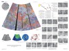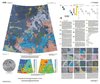
Venus Geologic Map of the Diana Chasma Quadrangle
- Primary Authors
- Vicki L. Hansen and Heather R. DeShon
- Publisher
- USGS Astrogeology Science Center
- Publication Date
- 2002-01-02
- Abstract
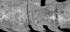
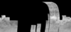
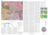
- Introduction The Diana Chasma quadrangle (V-37), an equatorial region between 0ð to 25ð S. and 150ð to 180ð E. that encompasses ~8,400,000 km2, is broadly divided into southern Rusalka Planitia in the north, eastern Aphrodite Terra in the central region, and unnamed regions to the south. Geologic mapping constrains the temporal and spatial relations of the major features, which include a tessera inlier, Markham crater, six large coronae (300-675 km diameter), four smaller coronae (150-225 km diameter), Diana and Dali chasmata, a large fracture zone, and southern Rusalka Planitia. Eastern Aphrodite Terra, marked here by large coronae, deep chasmata, and an extensive northeast-trending fracture zone, extends from Atla Regio to Thetis Regio. The large coronae are part of a chain of such features that includes Inari Corona to the west-southwest and Zemina Corona to the northeast. V-37 quadrangle is bounded on the north by Rusalka Planitia and on the south by Zhibek Planitia. International Astronomical Union (IAU) approved and provisional nomenclature and positions for geographic features within Diana Chasma quadrangle are shown on the geologic map. [Note: Atahensik Corona was referred to as Latona Corona in much previously published literature.] Diana Chasma quadrangle hosts some of the steepest topography on Venus. Altimetry measurements range from -2.5 to 4.7 km (0.0 = mean planetary radius), with a surface mean of 0.6 km. Fractures and faults within the central fracture/rift zone create large blocks of down-dropped material, especially along the east-central edge of the map area. The Dali and Diana chasmata display slopes of >30ð, the steepest and deepest trenches on Venus. Both chasmata host landslide deposits presumably sourced from the steep chasmata walls. The tessera inlier, coronae, and ridge belts sit topographically above Rusalka and Zhibek planitiae. Rusalka Planitia topography describes broad undulations having northwest-trending ridges spaced ~200 km apart. The most distinctive ridge, Vetsorgo Dorsum, centered at 6.5ð S., 163ð E., is a Class I ridge belt owing to its simple arch morphology. The central interior of Markham crater sits topographically lower than the surrounding region, which slopes downward to the east.
Contact and Distribution
- Format
- Geologic Map, Raster Data, Vector Data
- Access Scope
- Series Id
- 2752
- Native Data Set Environment
- Astrogeology Theme
- Cartography, Geology, Geomorphology, Photogeology, Planetary evolution, Stratigraphy
- Online Package Link
- https://astrogeology.usgs.gov/search/map/venus_geologic_map_of_the_diana_chasma_quadrangle
- External File Size
- 19406450
- Online File Link
- http://astropedia.astrogeology.usgs.gov/download/Venus/Geology/year-2000/Venus-Geologic-Map-of-the-Diana-Chasma-Quadrangle-V-37.pdf
- Access Instructions
- Sheet 54 by 40 inches (in color)
- Contact Address
- 2255 N. Gemini Drive
- Contact City
- Flagstaff
- Contact State
- AZ
- Contact Postal Code
- 86001
- Contact Email
- [email protected]
Geospatial Information
- Target
- Venus
- Well Known Text (WKT)
- POLYGON((150 0, 180 0, 180 -25, 150 -25, 150 0))
- Minimum Latitude
- -25
- Maximum Latitude
- 0
- Minimum Longitude
- 150
- Maximum Longitude
- 180
- Object Type
- Grid Cell
- Quad Name
- V-37
- Map Scale (hard-copy)
- 1:5000000
- Horizontal Coordinate System Units
- Degrees