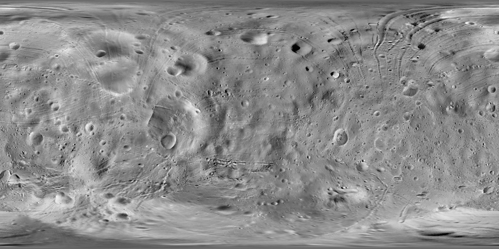
Phobos Viking Global Mosaic 5m
- Primary Authors
- Phil Stooke
- Originators
- Planetary Data System
- Publisher
- USGS Astrogeology Science Center
- Publication Date
- 2012-06-01
- Abstract
- Product Information: This mosaic of Phobos was created by compiling updated versions of Viking high-resolution mosaics and selecting the best high-resolution images from other spacecraft to construct an entirely new mosaic. The process of compiling this mosaic significantly improved areas of poor control. Where images with reverse lighting meet, artistic effects are necessary to create satisfactory appearance, but this affects the appearance only and not the map geometry. This global mosaic has a pixel resolution of five meters per pixel (m). Mission and Instrument Information: The Viking Project consisted of two identical spacecraft (Viking 1 & Viking 2) each consisting of a lander and an orbiter. The Viking spacecraft launched from Cape Canaveral, Florida onboard Titan IIIE-Centaur rockets. Viking 1 launched on August 20th, 1975; orbit insertion at Mars occurred on June 19, 1976 and the orbiter mission ended on August 17, 1980. Viking 1 lander touched ground on Mars on July 20th, 1976 in Chryse Planitia, the Viking 1 lander mission ended on November 13, 1982. Viking 2 launched on September 9; 1975; orbit insertion at Mars occurred on August 7, 1976 and the orbiter mission ended on July 25, 1978. Viking 2 lander touched ground on Mars on September 3rd, 1976 in Utopia Planatia, the Viking 2 lander mission ended on April 11, 1980. The Viking project is known as the first U.S. mission to land a spacecraft safely on the surface of Mars and return images of the surface. The primary objectives of the orbiters were to transport the landers to Mars, locate and certify landing sites, act as communication relay for the landers and perform scientific investigations. The science payload onboard Viking orbiters consisted of instruments for conducting imaging, atmospheric water vapor, and infrared thermal mapping. Phobos is the larger of Marsâ two moons, it orbits Mars three times a day and is nearing the planet at a rate of six feet every hundred years; at that rate, Phobos will crash into Mars in 50 million years. References: Stooke, P. (2012). Stooke Small Bodies Maps V2.0. MULTI-SA-MULTI-6-STOOKEMAPS-V2.0. NASA Planetary Data System. https://sbn.psi.edu/pds/resource/stookemaps.html Simonelli, D. P., Thomas, P. C., Carcich, B. T., & Veverka, J. (1993). The generation and use of numerical shape models for irregular solar system objects. Icarus, 103, 49-61. https://doi.org/10.1006/icar.1993.1057
- Purpose
- To produce a DLR-controlled image mosaic of Phobos using Viking Orbiter high-resolution images.
Contact and Distribution
- Format
- Global Mosaic, Remote-sensing Data
- Access Constraints
- public domain
- Access Scope
- PDS
- Use Constraints
- Please cite authors
- Edition
- 1
- Edition Name
- phobos_cyl_dlr_control
- Supplemental Information
- https://sbn.psi.edu/pds/archive/sc.html, https://sbn.psi.edu/pds/
- Native Data Set Environment
- ISIS v3
- Astrogeology Theme
- Geomorphology, Image Processing, Remote Sensing, Satellites
- Mission Names
- Viking Orbiter
- Instrument Names
- VIS
- Online Package Link
- https://astrogeology.usgs.gov/search/map/phobos_viking_global_mosaic_5m
- External File Size
- 99 MB
- Online File Link
- https://planetarymaps.usgs.gov/mosaic/Phobos_Viking_Mosaic_40ppd_DLRcontrol.tif
- Contact Address
- 2255 N. Gemini Drive
- Contact City
- Flagstaff
- Contact State
- AZ
- Contact Postal Code
- 86001
- Contact Email
- astroweb@usgs.gov
- Time Period of Content (stop)
- 2011-12-31
- Currentness Reference
- Ground condition
- Progress
- In Work
- Update Frequency
- As needed
- Logical Consistency
- please see abstract (above)
- Completeness Report
- It is anticipated to further improve and update this preliminary image mosaic.
- Process Description
- Images from the Viking mission were used and tied to the DLR-controlled mosaic of Phobos (Wahlisch, M., et al 2009). Wahlisch, M. et al., A new topographic image atlas of Phobos, Earth Planet. Sci. Lett., doi:10.1016/j.epsl.2009.11.003, 2009. (Available online at http://europlanet.dlr.de/node/index.php?id=214.)
Lineage
- Process Date
- 2012-06-01
- Source Title
- Stooke Small Bodies Maps V1.0. MULTI-SA-MULTI-6-STOOKEMAPS-V1.0
- Source Online Linkage
- {https://pds-imaging.jpl.nasa.gov/volumes/viking.html#vkoEDR,https://pds-imaging.jpl.nasa.gov/portal/vikingo_mission.html,https://sbn.psi.edu/pds/resource/stookemaps.html}
- PDS Status
- PDS 3 Archived
- Attribute Accuracy Report
- Best Effort
- Horizontal Positional Accuracy Report
- Best Effort
Geospatial Information
- Target
- Phobos
- System
- Mars
- Minimum Latitude
- -90
- Maximum Latitude
- 90
- Minimum Longitude
- -180
- Maximum Longitude
- 180
- Direct Spatial Reference Method
- Raster
- Object Type
- Grid Cell
- Raster Row Count (lines)
- 7200
- Raster Column Count (samples)
- 14400
- Bit Type (8, 16, 32)
- 8
- Quad Name
- Radius A
- 11100
- Radius C
- 11100
- Bands
- 1
- Pixel Resolution (meters/pixel)
- 4.8433
- Scale (pixels/degree)
- 40
- Map Projection Name
- Simple Cylindrical
- Latitude Type
- Planetocentric
- Longitude Direction
- Positive East
- Longitude Domain
- -180 to 180


