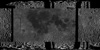
Moon Apollo Metric Albedo Mosaic
- Originators
- USGS Astrogeology Science Center
- Publisher
- USGS Astrogeology Science Center
- Publication Date
- 2010-01-15
- Abstract
-
The Apollo Metric Cameras were carried on the Apollo 15, 16, and 17 missions to map Earthâs Moon with a high degree of geometric fidelity.
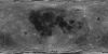
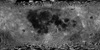
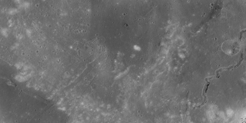
This PDS volume contains the "Apollo 15, 16, and 17 Metric Camera Albedo Mosaic" of Earth's Moon. The mosaic is a result of the albedo reconstruction detailed in Nefian et. al, 2012. The mosaic covers the mid-latitudes on the Earth-facing side of the Moon (sometimes referred to as the 'Apollo zone') and was compiled using more than 3,720 images from the Apollo Lunar Metric Camera on board the command modules of the Apollo 15, 16, and 17 missions.
The basemap mosaic is mapped in the equirectangular projection at a resolution of 10 meters per pixel requiring approximately 39 gigabytes of digital storage. The mosaic is partitioned into 887 tiles 3 degrees by 3 degrees in size. It spans a region extending from 56 degrees west to 180 degrees east and from 10 degrees north to 30 degrees south.
A detailed description of this Apollo Metric Camera Albedo Mosaic with information about the organization and compilation of the database is provided in the VOLINFO files located in the
directory. The Apollo 15, 16, and 17 Metric Camera Albedo Mosaic was compiled for the National Aeronautics and Space Administration (NASA) under the direction of Dr. Ara Nefian (Principal Investigator), Dr. Oleg Alexandrov, Zachary Moratto, Dr. Taemin Kim, Dr. Ross A. Beyer, and Dr. Terry Fong. The image files are organized according to NASA's PDS (v. 3) standards. An image file (tile) is organized as a PDS labeled file containing an "image object." Additionally, each image file is associated with an ISIS "qube object" and detached label. These data can be accessed and processed with the ISIS 3 software system, available through the USGS, Flagstaff, AZ (https://isis.astrogeology.usgs.gov). Metric Camera Description: The Apollo spacecraft system included a vacant area in the Service Module, called the Scientific Instrumentation Module (SIM) Bay, reserved for new instrumentation designed to meet Apollo mission lunar surface mapping goals. Beginning with Apollo 15, CSM SIM Bays contained a variety of instruments designed to characterize the Moon and its environment, including cameras as well as x-ray, alpha-particle, gamma-ray, and mass spectrometers to investigate the properties of the lunar surface. One of the cameras was the Apollo Lunar Metric Mapping Camera, frequently referred to as the Metric camera. During Apollo 15, 16, and 17 missions, over 7000 frames were acquired by the Apollo Lunar Mapping Cameras, resulting in coverage of ~20% of the Moon's surface at resolutions of about 10-20 meters per pixel. The Metric camera was produced by the Fairchild Corporation, and collected images of the Moon from lunar orbit through the Apollo 15, 16, and 17 missions. The Metric camera consisted of three systems: 1) The camera, which collected images of the lunar surface imprinted with reseau marks to compensate for film shrinking during processing 2) the stellar camera, which collected simultaneous exposures of the off-axis starfield in order to record the orientation of the spacecraft when each lunar image was obtained, and 3) the laser altimeter, which was used to determine and record the spacecraft's altitude over the lunar surface. Because the Service Module would be ejected prior to the Command Module's reentry into the Earth's atmosphere, the exposed film from the camera systems in the SIM Bay had to be retrieved during the return journey to Earth through an extravehicular activity (EVA). The Command Module Pilots of the last three Apollo missions--Al Worden (Apollo 15), Ken Mattingly (Apollo 16) and Ron Evans (Apollo 17)--performed EVAs in cislunar space to retrieve the exposed film canisters from the SIM Bay. References: Broxton, M., Nefian, A. V., Moratto, Z., Kim, T., Lundy, M., & Segal, A. (2009a). 3D lunar terrain reconstruction from Apollo images. Advances in Visual Computing, 710â719. https://link.springer.com/chapter/10.1007/978-3-642-10331-5_66 Broxton, M., Moratto, Z. M., Nefian, A., Bunte, M., & Robinson, M. (2009b). Preliminary stereo reconstruction from Apollo 15 Metric Camera imagery. Paper presented at the 40th Lunar and Planetary Science Conference, Lunar and Planetary Institute, Houston, TX. https://www.lpi.usra.edu/meetings/lpsc2009/pdf/2282.pdf Moratto, Z., Nefian, A., Kim, T., Broxton, R., & Fong, T. (2011). Stereo reconstruction from Apollo 15 and 16 Metric Camera. Paper presented at the 42nd Lunar and Planetary Science Conference, Lunar and Planetary Institute, Houston, TX. https://www.lpi.usra.edu/meetings/lpsc2011/pdf/2267.pdf Nefian, A. V., Moratto, Z., Beyer, R., Kim, T., Broxton, M., & Fong, T. (2012). Apollo Metric Zone Terrain Reconstruction. Paper presented at the 43rd Lunar and Planetary Science Conference, Lunar and Planetary Institute, Houston, TX. https://www.lpi.usra.edu/meetings/lpsc2012/pdf/2184.pdf Nefian, A. V., Kim, T., Moratto, Z., Beyer, R., Fong, T. (2010). Lunar Terrain and Albedo Reconstruction of the Apollo 15 Zone. In Bebis G. et al. (Eds.) Advances in Visual Computing. Lecture Notes in Computer Science (ISVC 2010, Vol. 6453). Springer, Berlin, Heidelberg. https://link.springer.com/chapter/10.1007/978-3-642-17289-2_66 - Purpose
- This project focused on generating accurate three dimensional planetary models using a novel approach for separation of topography and albedo maps from orbital lunar images. The method uses an optimal Bayesian correlator to refine the stereo disparity map and generate a set of accurate digital elevation models (DEM). The albedo maps are obtained using a multi-image formation model that relies on the derived DEMs and the Lunar- Lambert reflectance model. The method is demonstrated on a set of high resolution scanned images from the Apollo era missions.
Contact and Distribution
- Format
- Grey Scale, Image
- Access Scope
- PDS
- Series Id
- AMCAM_0001
- Edition
- March 2018
- Edition Name
- Archive Date
- Supplemental Information
- http://apollo.sese.asu.edu/, http://apollo.sese.asu.edu/METRIC_PREVIEW/index.html
- Native Data Set Environment
- Astrogeology Theme
- Astronaut Training, Exploration, Geomorphology, Image Processing, Remote Sensing, Selenology
- Mission Names
- Apollo
- Instrument Names
- MET
- Online Package Link
- https://astrogeology.usgs.gov/search/map/moon_apollo_metric_albedo_mosaic
- External File Size
- archive
- Online File Link
- https://pdsimage2.wr.usgs.gov/downloads/Apollo_Metric_Albedo_Mosaic/
- Contact Address
- 2255 N. Gemini Drive
- Contact City
- Flagstaff
- Contact State
- AZ
- Contact Postal Code
- 86001
- Contact Email
- [email protected]
- Currentness Reference
- Publication date
- Progress
- Complete
- Update Frequency
- None planned
- Logical Consistency
- The albedo mosaic relies on accurate terrain model for the computation of local normals. The terrain model is obtained using stereo pairs formed by consecutive images in each Apollo mission orbit. The resulting terrain models are further overlapping with terrain models derived from stereo pairs within the same orbit, adjacent orbits or other missions. The enhanced DTM of the Apollo Metric Camera Imagery combines all above terrain models using a statistical technique detailed in Section 3.2. Figure 1.2 illustrates the color- shaded relief of the enhanced DTM corresponding to the Apollo 15, 16 and 17 missions.
- Completeness Report
- The basemap mosaic is mapped in the equirectangular projection at a resolution of 10 meters per pixel requiring approximately 39 gigabytes of digital storage. The mosaic is partitioned into 887 tiles 3 degrees by three degrees in size. It spans from 56 degrees west to 180 degrees east and from 10 degrees north to 30 degrees south.
- Process Description
- These raw digital scans of the Apollo flight films were processed using a standard set of procedures. First, unexposed portions of the film along the edges of a scanned frame were cropped, and the frame was straightened. Second, the background was removed from all scans by assuming that the average DN values of the unexposed regions at the edge of each raw scanned image represent the background (i.e., film base and fog). Third, a flatfield correction (derived from the actual image data) removed vignetting to the first order. Fourth, the reseau patterns (the small white crosses visible on published Apollo images) were removed from the images. Fifth, a logarithmic histogram transformation was applied to the image to produce a virtual print that simulated the natural contrast of a conventional paper print. Sixth, since the uncompressed images produced by the initial scanning process result in extremely large images, the scale is reduced by a factor corresponding to the square root of 2 (which serves to reduce the image size by 50% to 1.3 Gbytes).
Lineage
- Process Date
- 2006-09-01
- Source Title
- Lunar Albedo Reconstruction From Apollo Metric Camera Imagery
- Source Online Linkage
- {http://apollo.sese.asu.edu/,http://pdsimage.wr.usgs.gov/archive/a15c-l-mc-2-scanned-images-v1.0/Â,http://pdsimage.wr.usgs.gov/archive/a16c-l-mc-2-scanned-images-v1.0/Â,http://pdsimage.wr.usgs.gov/archive/a17c-l-mc-2-scanned-images-v1.0/}
- Source PDS Archive
- Apollo
- PDS Status
- PDS 3 Archived
- Attribute Accuracy Report
- Best Effort
Geospatial Information
- Target
- Moon
- System
- Earth
- Minimum Latitude
- -30
- Maximum Latitude
- 10
- Minimum Longitude
- -56
- Maximum Longitude
- 180
- Direct Spatial Reference Method
- Raster
- Object Type
- Grid Cell
- Bit Type (8, 16, 32)
- 16
- Quad Name
- Radius A
- 1737400
- Radius C
- 1737400
- Bands
- 1
- Horizontal Coordinate System Units
- Degrees
- Longitude Direction
- Positive East
- Longitude Domain
- -180 to 180