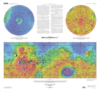
Mars Topographic and Color-Coded Contour Maps
- Publisher
- USGS Astrogeology Science Center
- Publication Date
- 2003-01-03
Contact and Distribution
- Format
- Topographic Map
- Access Scope
- RPIF
- Series Id
- 2782
- Native Data Set Environment
- Astrogeology Theme
- Cartography, Remote Sensing, Topography
- Online Package Link
- https://astrogeology.usgs.gov/search/map/mars_topographic_and_color_coded_contour_maps
- External File Size
- 2226633
- Online File Link
- http://astropedia.astrogeology.usgs.gov/download/Mars/Topography/year-2000/Mars-Topographic-and-Color-Coded-Contour-Maps.pdf
- Access Instructions
- 2 maps : col. ; 33 x 86 cm. with 2 spheres each 28 cm. in diam., on sheets 82 x 92 cm., folded in envelope 30 x 24 cm.
- Contact Address
- 2255 N. Gemini Drive
- Contact City
- Flagstaff
- Contact State
- AZ
- Contact Postal Code
- 86001
- Contact Email
- [email protected]
Geospatial Information
- Target
- Mars
- Object Type
- Grid Cell
- Quad Name
- Map Scale (hard-copy)
- 1:25000000
- Horizontal Coordinate System Units
- Degrees