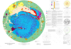
Mars Geologic Map of the North Polar Region
- Originators
- K. Tanaka, C. Fortezzo
- Publisher
- USGS Astrogeology Science Center
- Publication Date
- 2012-02-12
- Abstract
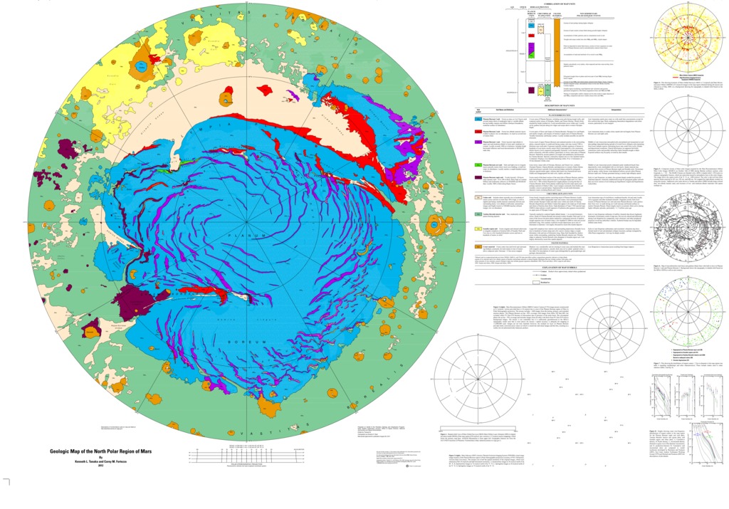
- The north polar region of Mars occurs within the central and lowest part of the vast northern plains of Mars and is dominated by the roughly circular north polar plateau, Planum Boreum. The northern plains formed very early in Martian time and have collected volcanic flows and sedimentary materials shed from highland sources. Planum Boreum has resulted from the accumulation of water ice and dust particles. Extensive, uncratered dune fields adjacent to Planum Boreum attest to the active and recent transport and accumulation of sand. Our geologic map of Planum Boreum is the first to record its entire observable stratigraphic record using the various post-Viking image and topography datasets released before 2009. We also provide much more detail in the map than previously published, including some substantial revisions based on new data and observations. The available data have increased and improved immensely in quantity, resolution, coverage, positional accuracy, and spectral range, enabling us to resolve previously unrecognized geomorphic features, stratigraphic relations, and compositional information. We also employ more carefully prescribed and effective mapping methodologies and digital techniques, as well as formatting guidelines. The foremost aspect to our mapping approach is how geologic units are discriminated based primarily on their temporal relations with other units as expressed in unit contacts by unconformities or by gradational relations. Whereas timing constraints of such activity in the north polar region are now better defined stratigraphically, they remain poorly constrained chronologically. The end result is a new reconstruction of the sedimentary, erosional, and structural histories of the north polar region and how they may have been driven by climate conditions, available geologic materials, and eolian, periglacial, impact, magmatic, hydrologic, and tectonic activity.
Contact and Distribution
- Format
- Geologic Map, Polar Map, Raster Data, Vector Data
- Access Scope
- RPIF
- Series Id
- 3177
- Native Data Set Environment
- Astrogeology Theme
- Cartography, Geology, Geomorphology, Photogeology, Planetary evolution, Stratigraphy
- Online Package Link
- https://astrogeology.usgs.gov/search/map/mars_geologic_map_of_the_north_polar_region
- External File Size
- 33587737
- Online File Link
- http://astropedia.astrogeology.usgs.gov/download/Mars/Geology/year-2010/Mars-Geologic-Map-of-the-North-Polar-Region.pdf
- Access Instructions
- Pamphlet: i, 11 p.; 1 Sheet: 60 x 44 inches; Readme File; Metadata Folder; GIS Database
- Contact Address
- 2255 N. Gemini Drive
- Contact City
- Flagstaff
- Contact State
- AZ
- Contact Postal Code
- 86001
- Contact Email
- [email protected]
Geospatial Information
- Target
- Mars
- Well Known Text (WKT)
- MULTIPOLYGON (((0 90, 360 90, 360 75, 0 75, 0 90)))
- Minimum Latitude
- 75
- Maximum Latitude
- 90
- Minimum Longitude
- 0
- Maximum Longitude
- 360
- Object Type
- Grid Cell
- Quad Name
- MC-1
- Map Scale (hard-copy)
- 1:2000000
- Map Projection Name
- Polar Stereographic