
Mars Geologic Map of the Elysium Region GIS Conversion
- Primary Authors
- Michelle Barton
- Originators
- Kenneth L. Tanaka, Mary G. Chapman, David H. Scott
- Publisher
- USGS Astrogeology Science Center
- Publication Date
- 2016-07-18
- Abstract
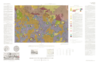
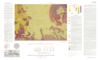
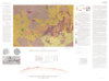
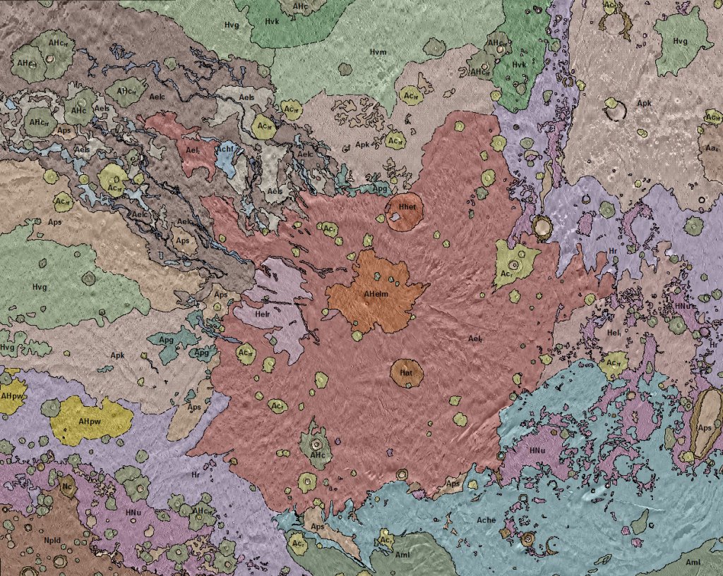
- The original map document was created in 1992 as a Mercator projection and is based on older Viking images. It was scanned and georeferenced into ArcGIS in two parts that are located in Elysium_5M_Viking/Raster/Elysium_clip3_RECTIFY and Elysium_clip4_RECTIFY. An uncontrolled THEMIS 100 mpp basemap and a MOLA hillshade were used for georeferencing. Control point links can be found in Elysium_5M_I2147_Viking/Raster/Elysium_I2147_clip3_links and Elysium_I2147_clip4_links. The geologic structures mapped on the original map document were not digitized or converted into GIS. References: Kenneth L. Tanaka, Mary G. Chapman, and David H. Scott, 1992, Geologic map of the Elysium region of Mars: U.S. Geological Survey Investigations Series Iâ2147, scale 1:5000000, http://pubs.er.usgs.gov/publication/i2147
- Purpose
- GIS conversion of the original 1992 published map.
Contact and Distribution
- Format
- Geologic Map
- Access Constraints
- None
- Access Scope
- MRCTR
- Use Constraints
- None
- Edition
- 1
- Native Data Set Environment
- ESRI Arcinfo, GDAL
- Astrogeology Theme
- Geographic Information System (GIS), Geology, Photogeology
- Temporal Keywords
- Amazonian, Hesperian, Noachian
- Mission Names
- Viking
- Instrument Names
- VIS
- Online Package Link
- https://astrogeology.usgs.gov/search/map/mars_geologic_map_of_the_elysium_region_gis_conversion
- External File Size
- 452285291
- Online File Link
- http://astropedia.astrogeology.usgs.gov/download/Mars/Geology/Mars_Elysium_5M_I2147_Viking_GIS.zip
- Contact Address
- 2255 N. Gemini Drive
- Contact City
- Flagstaff
- Contact State
- AZ
- Contact Postal Code
- 86001
- Contact Email
- [email protected]
Data Status and Quality
- Time Period of Content (start)
- 2016-05-01
- Time Period of Content (stop)
- 2016-07-18
- Currentness Reference
- Publication date
- Progress
- Complete
- Update Frequency
- None planned
- Completeness Report
- No structure was digitized.
- Process Description
- Original map contacts (approximate and certain) were digitized with a streaming tolerance of 1500 meters at a 1:750000 scale. The polylines were then converted into polygons which were attributed with the same geologic symbols and colors as shown on the original scanned map. There were no revisions made to the preexsiting geologic contacts in order to preserve the original documentation of the units.
Lineage
- Process Date
- 2016-07-18
- Source Title
- Geologic map of the Elysium region of Mars: U.S. Geological Survey Investigations Series Iâ2147
- Source Online Linkage
- http://pubs.er.usgs.gov/publication/i2147
- Attribute Accuracy Report
- Unknown
- Horizontal Positional Accuracy Report
- Unknown
- Vertical Positional Accuracy Report
- Unknown
Geospatial Information
- Target
- Mars
- System
- Mars
- Feature Name
- Elysium
- Minimum Latitude
- 47.5
- Maximum Latitude
- 0
- Minimum Longitude
- 112.5
- Maximum Longitude
- 180
- Direct Spatial Reference Method
- Vector
- Object Type
- Grid Cell
- Quad System
- Mars 1:5M
- Quad Name
- MC-2, MC-6, MC-7, MC-8, MC-14, MC-15, MC-16, MC-22, MC-23
- Radius A
- 3396190
- Radius C
- 3396190
- Control Net
- Viking
- Map Scale (hard-copy)
- 5000000
- Map Projection Name
- Mercator
- Latitude Type
- Planetocentric
- Longitude Direction
- Positive East
- Longitude Domain
- -180 to 180