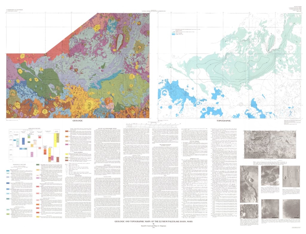
Mars Geologic and Topographic Maps of the Elysium Paleolake Basin
- Originators
- D. Scott, M. Chapman
- Publisher
- USGS Astrogeology Science Center
- Publication Date
- 1996-01-03
Contact and Distribution
- Format
- Geologic Map, Raster Data, Vector Data
- Access Scope
- RPIF
- Series Id
- 2397
- Native Data Set Environment
- Astrogeology Theme
- Cartography, Geology, Geomorphology, Photogeology, Planetary evolution, Remote Sensing, Stratigraphy, Topography
- Online Package Link
- https://astrogeology.usgs.gov/search/map/mars_geologic_and_topographic_maps_of_the_elysium_paleolake_basin
- External File Size
- 17325174
- Online File Link
- http://astropedia.astrogeology.usgs.gov/download/Mars/Topography/year-1990/Mars-Geologic-and-Topographic-Maps-of-the-Elysium-Paleolake-Basin.pdf
- Access Instructions
- 2 photomaps :col. ;each 49 x 66 cm., on sheet 105 x 140 cm., folded in envelope 30 x 24 cm.
- Contact Address
- 2255 N. Gemini Drive
- Contact City
- Flagstaff
- Contact State
- AZ
- Contact Postal Code
- 86001
- Contact Email
- [email protected]
Geospatial Information
- Target
- Mars
- Well Known Text (WKT)
- MULTIPOLYGON (((135 25, 190 25, 190 -15, 135 -15, 135 25)))
- Minimum Latitude
- -15
- Maximum Latitude
- 25
- Minimum Longitude
- 135
- Maximum Longitude
- 190
- Object Type
- Grid Cell
- Quad Name
- MC-8, MC-14, MC-15, MC-16, MC-22, MC-23
- Map Scale (hard-copy)
- 1:5000000
- Map Projection Name
- Mercator