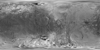

Iapetus Voyager Airbrush Global Mosaic 783m
- Originators
- USGS Astrogeology Science Center
- Publisher
- USGS Astrogeology Science Center
- Abstract
- This image mosaic is one of several products created as the first step of cartography planning in support of the Cassini-Huygens Mission to Saturn & Titan. The data included in these mosaics were collected by both Voyager I and Voyager II missions. The Cassini spacecraft is targeting these moons and others during the mission. Reference: U.S. GEOLOGICAL SURVEY 1992. Preliminary Pictorial map of Iapetus. U.S. Geol. Surv. Misc. Invest. Ser. Map I-2159, scale 1:10,000,000.
- Purpose
- Pictorial map and controlled photomosaic of Iapetus used for the Cassini mission.
Contact and Distribution
- Format
- Airbrush, Global Mosaic, Raster Data, Remote-sensing Data
- Access Constraints
- Public domain
- Access Scope
- Use Constraints
- None
- Supplemental Information
- http://pubs.er.usgs.gov/publication/i2159
- Native Data Set Environment
- ISIS v3
- Astrogeology Theme
- Geomorphology, Remote Sensing
- Mission Names
- Voyager
- Instrument Names
- VIS
- Online Package Link
- https://astrogeology.usgs.gov/search/map/iapetus_voyager_airbrush_global_mosaic_783m
- External File Size
- 16658111
- Online File Link
- http://astropedia.astrogeology.usgs.gov/download/Iapetus/Voyager/Iapetus_Voyager_airbrush_mosaic_global_783m.cub
- Contact Address
- 2255 N. Gemini Drive
- Contact City
- Flagstaff
- Contact State
- AZ
- Contact Postal Code
- 86001
- Contact Email
- [email protected]
- Source Online Linkage
- http://astrogeology.usgs.gov/site/planetaryIndex?mapNumber=18
Geospatial Information
- Target
- Iapetus
- System
- Saturn
- Minimum Latitude
- -90
- Maximum Latitude
- 90
- Minimum Longitude
- -180
- Maximum Longitude
- 180
- Direct Spatial Reference Method
- Raster
- Object Type
- Grid Cell
- Raster Row Count (lines)
- 2880
- Raster Column Count (samples)
- 5760
- Bit Type (8, 16, 32)
- 8
- Quad Name
- Radius A
- 718000
- Radius C
- 718000
- Bands
- 1
- Pixel Resolution (meters/pixel)
- 783.21650183245
- Scale (pixels/degree)
- 16
- Map Projection Name
- Simple Cylindrical
- Latitude Type
- Planetocentric
- Longitude Direction
- Positive West
- Longitude Domain
- -180 to 180