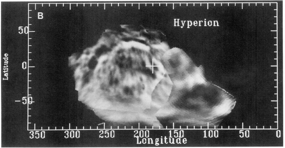
Hyperion Image Control Network
- Originators
- USGS Astrogeology Science Center
- Publisher
- USGS Astrogeology Science Center
- Abstract
-
This page has been created as part of a project to put planetary control networks on the web. These control network measurements for Saturnâs moon, Hyperion, originated from Merton Davies and Tim Colvin and Frank Katayama at the RAND Corporation, and Peter Thomas from Cornell University, and were provided to the USGS in 2000. Although control-network measurements exist for Hyperion, no control network was ever completed for it due to its chaotic rotation. The input files included here consist of measurements of common points (control points, sometimes called tie points) on images of a planetary body. The output files include the body coordinates of the control points in latitude, longitude, and radius, and revised orientation information (camera pointing) for the images. The primary use of such information is for the creation of image mosaics of the planetary body. However, controlled solutions can also provide fundamental data on the size and shape of the body, its rotation period, and the direction of its polar axis in space. The control point coordinates also usually serve as a coordinate reference frame that defines the fundamental coordinate reference system for the body in question. Formatting of these control network data for Saturnâs moon, Hyperion, has yet to be updated for compatibility with the USGS ISIS2 and ISIS3 cartography software.
Image Description:
This global mosaic of Hyperion utilizes only 4 images: 4394328, 4395906, 4396802 and 4397243. Simple cylindrical map projection. Images have been high-pass filtered. - Purpose
- Created as part of a project to put planetary geodesy control networks on the web. The Hyperion Voyager control network data here was originally provided by Merton Davies and Tim Colvin of the RAND Corporation. Funds were provided for a conversion and archiving effort by the NASA Planetary Geology and Geophysics Program and the NASA Cartography Program.
Contact and Distribution
- Format
- Control Network
- Access Scope
- Native Data Set Environment
- Astrogeology Theme
- Control Network
- Mission Names
- Voyager
- Online Package Link
- https://astrogeology.usgs.gov/search/map/hyperion_image_control_network
- External File Size
- 3513250
- Online File Link
- http://astropedia.astrogeology.usgs.gov/download/Hyperion/ControlNetworks/Hyperion_data.zip
- Access Instructions
-
Contained in the ZIP file are the Hyperion control points generated by RAND, and the original Voyager control images in PDS (.imq) format. No control network has been generated for Hyperion due to its chaotic rotation.
Hyperion_data.zip Contents:
Hyperion_control_images.zip â All Voyager images, used by RAND to generate the control points provided here, in PDS (.imq) format.
hyppix.dat â RAND âpoles, points, and positionsâ a priori input file.
hyppts.dat â RAND pixel measurements input file.
hypmea.dat â RAND measurement file containing both pixel and millimeter measuremetns.
Documentation and Information:
Hyperion_image_list.txt â Text file listing all Voyager images in the Hyperion control network. These images are archived at pds.nasa.gov in PDS (.imq) format.
ISIS-PG-FMT503_meaXX_dat â Description of format of file hypmea.dat (in PDF format).
- Contact Address
- 2255 N. Gemini Drive
- Contact City
- Flagstaff
- Contact State
- AZ
- Contact Postal Code
- 86001
- Contact Email
- astroweb@usgs.gov
Geospatial Information
- Target
- Hyperion
- System
- Saturn
- Object Type
- Grid Cell
- Quad Name
- Horizontal Coordinate System Units
- Degrees


