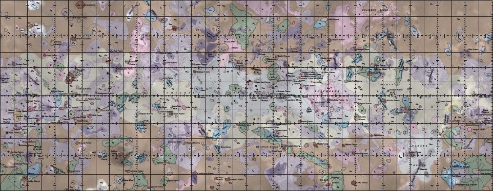
Geologic Map of Io, SIM 3168
- Primary Authors
- David A. Williams
- Originators
- Laszlo P. Keszthelyi, David A. Crown, Jessica A. Yff, Windy L. Jaeger, Paul M. Schenk, Paul E. Geissler, Tammy L. Becker
- Publisher
- USGS Astrogeology Science Center
- Publication Date
- 2012-03-13
- Abstract
- Io, discovered by Galileo Galilei on January 7-13, 1610, is the innermost of the four Galilean satellites of the planet Jupiter. It is the most volcanically active object in the Solar System, as recognized by observations from six U.S. National Aeronautics and Space Administration (NASA) spacecraft: Voyager 1 (March 1979), Voyager 2 (July 1979), Hubble Space Telescope (1990-Present), Galileo (1996-2001), Cassini (December 2000), and New Horizons (February 2007). The lack of impact craters on Io in any spacecraft images at any resolution attests to the high resurfacing rate (~1 cm/yr) and the dominant role of active volcanism in shaping its surface (Johnson and others, 1979). High-temperature hot spots detected by the Galileo Solid-State Imager (SSI), Near-Infrared Mapping Spectrometer (NIMS) and Photopolarimeter-Radiometer (PPR) usually correlate with darkest materials on the surface, suggestive of active volcanism. The Voyager flybys obtained complete coverage of Io's subjovian hemisphere at ~500 m/pixel to 2 km/pixel and most of the rest of the satellite at 5-20 km/pixel. Repeated Galileo flybys obtained complementary coverage of Io's antijovian hemisphere at 5 m/pixel to 1.4 km/pixel. Thus, the Voyager and Galileo data sets were merged to enable the characterization of the whole surface of the satellite at a consistent resolution.The U.S. Geological Survey (USGS) produced a set of four global mosaics of Io in visible wavelengths at a spatial resolution of 1 km/pixel, released in February 2006, which we have used as base maps for this new global geologic map. Suggested Citation: Williams, D.A., Keszthelyi, L.P., Crown, D.A., Yff, J.A., Jaeger, W.L., Schenk, P.M., Geissler, P.E., and Becker, T.L., 2011, Geologic map of Io: U.S. Geological Survey Scientific Investigations Map 3168, scale 1:15,000,000, 25 p., available at http://pubs.usgs.gov/sim/3168 References: Bagenal, F., W. McKinnon, and T. Dowling, 2004, Jupiter: planet, satellites and magnetosphere: New York, Cambridge University Press, 719 p. Davies, A.G., 2007, Volcanism on Io: London, Cambridge University Press, 355 p. Lopes, R.M.C., and Spencer, J.R., 2007, Io After Galileo: Chichester, UK, Springer/Praxis Publishers, 342 p. Becker, T., and Geissler, P., 2005, Galileo global color mosaics of Io:, Houston, Lunar and Planetary Institute, Lunar and Planetary Science XXXVI, Abstract #1862 (CD-ROM).
- Purpose
- Much has been learned about Io's volcanism, tectonics, degradation, and interior since the Voyager flybys, primarily during and following the Galileo Mission at Jupiter (December 1995-September 2003). Our mapping incorporates this new understanding to assist in map unit definition and provide a global synthesis of Io's geology.
Contact and Distribution
- Format
- Geologic Map, Nomenclature
- Access Constraints
- public domain
- Access Scope
- MRCTR, PGM, RPIF
- Use Constraints
- Please cite authors
- Series Id
- 3168
- Edition
- 1
- Supplemental Information
- http://pubs.usgs.gov/sim/3168/
- Native Data Set Environment
- ESRI Arcinfo
- Astrogeology Theme
- Geographic Information System (GIS), Geology, Volcanism
- Mission Names
- Galileo, Voyager
- Instrument Names
- Voyager 1, Voyager 2
- Online Package Link
- https://astrogeology.usgs.gov/search/map/geologic_map_of_io_sim_3168
- External File Size
- 281070604
- Online File Link
- http://astropedia.astrogeology.usgs.gov/download/Io/Geology/Io_SIM3168_Database.zip
- Contact Address
- 2255 N. Gemini Drive
- Contact City
- Flagstaff
- Contact State
- AZ
- Contact Postal Code
- 86001
- Contact Email
- astroweb@usgs.gov
Data Status and Quality
- Time Period of Content (start)
- 2006-05-01
- Time Period of Content (stop)
- 2011-05-01
- Currentness Reference
- Ground condition
- Progress
- Complete
- Update Frequency
- None planned
- Logical Consistency
- These data are believed to be logically consistent. Line geometry is topologically clean.
- Completeness Report
- Completed at the given scale for publication by USGS.
- Process Description
- Geologic mapping of Io has focused on specific types of geologic material units and structural features, as first recognized by Schaber (1980, 1982). The reasons for this are (1) the quantity of concurrent volcanic activity on Io and (2) the variable quality of the global spacecraft data. These constraints mean that it is not practical to separate map units based on both age and lithology. The mapping strategy developed for the global map was initially tested through mapping of the polar regions with ArcGIS software (by Esri) and then applied to the equatorial region.
Lineage
- Process Date
- 2011-05-01
- Source Title
- Galileo global color mosaics of Io
- Source Online Linkage
- http://astrogeology.usgs.gov/maps/io-voyager-galileo-global-mosaics
- Attribute Accuracy Report
- Accurate to Control Net
- Horizontal Positional Accuracy Report
- Accurate to Control Net
Geospatial Information
- Target
- Io
- System
- Jupiter
- Minimum Latitude
- -90
- Maximum Latitude
- 90
- Minimum Longitude
- 0
- Maximum Longitude
- 360
- Direct Spatial Reference Method
- Vector
- Object Type
- Grid Cell
- Quad Name
- Radius A
- 1821460
- Radius C
- 1821460
- Map Projection Name
- Simple Cylindrical
- Latitude Type
- Planetocentric
- Longitude Direction
- Positive West
- Longitude Domain
- 0 to 360


